Place Names (S) Sailor's Rest - Swan Island
Sailor's Rest, Renton
This was one of the houses which were built into the eastern slope from Main Street to the towpath, more or less opposite the School Green. Many of the houses on this part of eastern side of Main street had one or two storeys below the level of Main Street with doors and windows opening out onto the towpath, but most of the rest of the lower house built into the embankment.
Until the coming of the railways in the 1850's there was a brisk river-based trade with scows carrying coal, wood, fertilisers etc up and down the Leven to and from the Clyde and Lochside. Sailors seeking a place for the night could find it in this house beside the Long Stairs. It lost any sailor trade by the 1860's, but the houses still stood, with almost all of the lower level houses no longer in use, until the demolitions of the 1950's.
Sallochy
This area lies on the loch’s east shore about halfway between Rowardennan and Balmaha. These days its main feature is the Glasgow University Research Centre, but it has had quite an active history. Sallochy is derived from the Gaelic “salach”, meaning dirty, which is totally at odds with its present-day aspect. Over the years there have been many spellings of the name including Sallachy, Sallachie and Salachi, so it’s another of these place names where the rule is “if it looks like Sallochy, then it probably is Sallochy”. There is a Sallochy Forestry car-park sitting astride the West Highland Way from which a variety of walks spread out beside the Loch and into the woods on the east side of the road.
Sandbank, Jamestown
This is the area on the Jamestown - Bonhill road at which the boundary between the two villages lies, in the form of Sandbank Burn. Originally Sandbank consisted of just a red sandstone terrace, probably built for the workers of nearby Dalmonach Works, and a few detached houses, but it has become slightly more built up, with the houses of the Lade on the other side of the road, while the new private houses of Ferry Field have been built in the last 2-3 years (i.e. 2005 - 6).
Sauchieha', also known as Lockhart Street and Jock's Loan, Alexandria
This is the nickname for the narrow lane at the north end of the Gilmour Street car park (running down the south wall of Leven Cottage) which joins the car park to the Main Street, just about the bus stop. Presumably the Sauchieha' is an ironic allusion to Sauchiehall Street. Lockhart was a blacksmith who had his smiddy in the area in the early-mid 1800's
Schoolhouse Park
Schoolhouse Park, in Alexandria, which was owned by the Smolletts, was much used in the last few decades of the 19th century, and there are many references to it in a number of contexts, but no map nor written description shows its exact location. So we’re left to examine the clues, the first of which, “Schoolhouse”, is of no use at all. We know that the grand parade at the laying of the memorial stone for the new Co-op Hall in Bank Street in 1895 gathered there before marching along Middleton Street, down Hill Street onto Main Street and on its way to eventually arrive at Bank Street. It was thus beyond the south end of Middleton Street, which had been completely built upon by then.
We also know that the Tennis Club had its first courts on Schoolhouse Park even before that. Finally, we know that Mr. Wedgwood, the owner of Dennistoun Forge, who built and lived in Alexandria House, in what became Upper Smollett Street, rented part of Schoolhouse Park in 1895. It is still being mentioned in 1908 as where the Tennis Courts are. From all that evidence, it is most likely that the location for the Park is the east side of Upper Smollett Street; and that the Tennis Club started there and stayed there until its demise in the 1960’s. “Why Schoolhouse?” is another question. We can now confirm from later Valuation Rolls that Schoolhouse Park was indeed located on the east side of Upper Smollett Street where Alexandria Tennis Cub built its tennis court; the site is now a private detached house. There was only one schoolhouse in Alexandria which went by that name at that time and that was at 23-27 Bridge Street, so it’s possible that the children from there and then Main Street School used it as a recreation park.
Scott Street, Bonhill
This short street, which is a cul-de-sac running northwards from Dalmonach Road just before it joins Northfield Road, dates from about 1880. It is probably named after a James Scott who was one of the partners of James Black & Co, owners of Dalmonach Works from about 1830 until it joined the Calico Printers Association.
Shanacles
This is a former farm, about halfway between Ballagan and Gartocharn, whose name derives from the Gaelic “sean eaglais” meaning old church. It lies on land granted in 1450 to the Friars Preachers of Glasgow by Isabella Duchess of Lennox, so it's a fair bet that both it and the adjoining farm of Old Kirk had medieval church buildings on them. These would have been small, perhaps a chapel or a very small monastic retreat.
No remains of a church building have been found, although it is fair to say that no serious attempt has been made to find one. Other archaeological remains have been found on Old Kirk, which mainly seem to relate to burials from pre-Christian times.
Shandon Brae & Crescent, Balloch
Shandon means an “old fort” in Gaelic. However this does not means that there was ever a fort on the crest of the brae on what was the old Dumbarton - Stirling road - there most certainly was not. What there was and still is, however, was a red sandstone semi-detached villa, dating from about 1890-1900, which was called Shandon, and the Brae and Crescent are named after it.
Both streets were the first to be started and occupied in the new Haldane scheme, with entry beginning in 1954. Many of the original residents came over from Greenock and Gourock to work in the Torpedo Factory after the closure of the Greenock Torpedo Factory - that was true of many of the first residents of the first phase of Haldane. The 3-storey flats in Shandon Crescent attracted a lot of attention at the time because they were using a new type of soundproofing, which most occupiers agreed was pretty effective.
Shearer Quadrant, Haldane
In the heart of the Haldane, this cul-de-sac on the north side of Cook Road was built about 1954. There are plenty of prominent Vale Shearers after whom it could have been named, including a teacher at Jamestown School, Miss “Daddy” Shearer, and James Shearer an Alexandria joiner and builder as well as being member of the old Parochial Council. However, it was called after Adam Shearer who represented Tullichewan on Bonhill Parish Council on a Labour ticket (he was a member of the Independent Labour party or ILP as they were better known) from 1919 – 1923.
In February 1922 he replaced Peter Talbot as Chairman of the Council. For all of his chairmanship he was between a rock and a hard place under constant pressure from his colleagues on the Left to increase poor relief and from the Right and the government not to do so. He had to sign his personal bond not to allow the government scales of poor relief to be exceeded before the government provided any money to allow the relief payments to be made. The impossibility of his position was recognised by most of his councillor colleagues but that didn’t stop the occasional personal abuse being aimed at him.
It's hard to avoid the conclusion that the stress of his chairmanship played a big part in his decision to get as far away from the Vale as possible, although he never actually said that in public. In November 1922 after about 22 months in the Chair of the Parish Council he announced that he was emigrating to New Zealand and promptly resigned from both the Chairmanship and the Council. Leaving the Council must have been a great personal relief and when he said that he had presided over the most strenuous period in the Council’s history, he was understating the challenges he had faced and the contribution which he had made. No Vale councillor since has faced the problems he had to contend with in such difficult economic and political times.
Shincut, Renton
This was a short cut (shincut is in fact the Scots for “short cut”) between Main Street and Back Street about halfway between King Street and Red Row. It ran alongside the original Kind Man pub. It disappeared when the houses in the area were demolished in the late 1950's - early 1960's.
Simpson Quadrant, Haldane
Rev William Simpson is the person after whom this is named and there were plenty of reasons for that. Not only was he a long serving minister of Bonhill Parish Church from 1878 until his death in 1913, he was also a County Councillor, Bonhill Parish Councillor and Chairman of Bonhill School Board. Just about any one of these elected positions would have earned him a street name in the Haldane in the mid 1950’s when the houses were built.
Sledge Runs, The Vale
Being a valley, the Vale was well endowed with sledge runs. In the post war period, all of them were well used in what seemed to be a much snowier climate. Most sledge runs were known by their length. None were officially sanctioned, and the reaction of the landowners to this use of their land varied, with the Vale Golf Club in Bonhill being understandably the most upset, and the only one to take practical measures against the sledgers.
On the east side of the valley, the Golf Club's half-mile and quarter mile were the best known and used. Sledging certainly did damage to the course, which the Club spent a considerable amount of money maintaining and developing, and the Club put iron stakes across the runs at appropriate points.
On the west side, the Ritchie Hill was the favourite of people living in the centre of the Vale. However, the Half and Quarter mile runs at Tullichewan, coming down through what is now Stoneymollan Roundabout and the link road from the bypass to the Balloch roundabout, were easily the best and attracted people from all over the northern end of the Vale, as well as the locals in Tullichewan and Levenvale.
The hill in front of Balloch Castle was definitely off limits - this was still the era of “Keep Off the Grass” in public parks, and apart from anything else, the gates were locked at dusk. Hard to believe, but there was a well used short run adjacent to Carrochan Road Bridge, from what is now Craig Lynn Gardens and the Library down to the Burn.
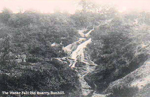
Slunger, The, Bonhill
This is / was one of the most famous tracks and walks in the Vale for well over a century, and is still celebrated in many poems. It ran from about Hillbank Street, just south of the Golf Course, to Auchencarroch Road. In other words, it followed a very similar line to the present Northfield Road and indeed it could be said to have disappeared under Northfield Road in the late 1940’s when the new Dalmonach housing scheme was built – much regretted but certainly not forgotten.
Many people have asked what is the origin of the name Slunger? We have to say that we don’t have a definite answer but Bonhill man and website contributor Graham Lappin has suggested two possibilities.
The first can be found at http://www.geograph.org.uk/photo/974462 which includes a stone relief artwork which is attached to the outside wall of the Veterans Bowling Club in George Street Bonhill. This website says of The Slunger, "The road was once called Slunger Hill Road, a name that is connected to the textile industry that was once prominent in that area. To "slunge" or "slounge" meant, in Old Scots, to "souse with water", and it was an activity that was carried out in the local bleachfields."
That sounds a possibility, especially given its proximity to Dalmonach (“the field of monks”) which long before it was a textile finishing factory was a place where the monks cleaned and dried their salmon fishing nets which they used in the Leven.
So cleaning nets or bleached cotton with water is one possible origin. However, closer consideration raises a few doubts. Firstly, the original bleachfields came to the Valley of the Leven to use the water from the Leven, drawn from the river into lades and the bleachfield operations were all conducted immediately adjacent to the river. The Slunger is well above the Leven and no water was ever pumped up there from the Leven, so that raises one doubt about slunging out with water in the area of the Slunger. A further doubt would be that in the bleachfield days the bleaching of cloth in open fields happened only in the summer when the bleached cloth was dried by the sun – a method which is bound to raise a few eyebrows with to-day’s rain-sodden Vale folk. Even if the cloth was laid out up on these fields the water to slunge it out could only come from hillside burns and if there was sun to bleach the cloth then there would be very little water in these burns. So if slunging bleached cloth sounds plausible on one level, on closer examination it seems a bit doubtful.
We have to say, by the way, that we haven’t found any other reference to Slunger Hill Road, but we’ll keep looking. In any event Slunger Hill Road would be as applicable to the second possible origin as it is to the first. The second possibility is this.
The Scots on-line dictionary lists the verb sloonge and / or slunge and says that it means to idle or loaf about, to move or walk in a slouching, lethargic manner; to behave furtively and stealthily, to skulk in a sneaky way, to hang about in the hope of getting food. It then goes on to list the noun sloonger or slunger as “A lazy, lounging creature, a person with a dull, hungry, skulking appearance or disposition, a lounger. A person or animal which is always on the look-out for food. A skulking, sneaking person, a sly, mean, trouble-making, untrustworthy fellow.”
Bonhill had at least 16 places which sold alcohol in the 19th century. It even had a distillery which burned down in 1827 and has so far not been replaced. The distillery was located just about the southern end of the Slunger. So it seems perfectly possible that some Bonhill men having partaken of a wee dram or two wandered off into the countryside to either walk or sleep off their drunkenness and that since they could reasonably be described as “slungers”, the track they took became known as the Slungers Hill Road or something similar.
This “slunging” tradition of course carried on in Bonhill until the latter stages of the 20th century, although by then it had relocated to Bonhill Bridge. The groups of men who hung about Bonhill Bridge went unrecognised as part of the rich cultural heritage of the village and were unfairly regarded as an anti-social element who would neither work nor want instead of as the inheritors of the mantle of men who were so well thought of that they had had a road named after them
Finally, the burn at Bonhill arrives via the waterfall on the east side of Hillbank Street. This was once an open burn all the way from Hillbank Street to the river Leven before being piped and covered over in 1929. This of course gave Burn Street its name. The waterfall itself may have been referred to as "the slunger" and the name may have also evolved as a reference to the track or road which started at the foot of the waterfall.
In the absence of any other evidence one way of the other, but bearing in mind which of these possibilities would seem a better fit for the Vale, we will leave you to make up your own mind which is the more likely origin of the name.
Note1: we would be delighted to hear from anyone who has anything to add to this (as with all content on this website).
Smollett Monument, Renton
This Tuscan column was erected in memory of Dr Tobias Smollett (1721 - 71), who was born at Dalquhurn and died in Livorno (Leghorn), Italy. Although he trained as a medical doctor, and served for many years as a ship's surgeon in the Royal Navy, Tobias Smollett earned his place in history as a writer. He was one of the earliest novelists in the English language and his novels Roderick Random and Humphrey Clinker are still read, although not in Scottish schools.
He also wrote a poem “Ode to Leven Water” which is rarely given an outing, even in Renton. At the moment he is making something of a comeback. If Tobias Smollett had lived another four years, until November 1775, when his cousin James died without heirs, he would have inherited the Smollett of Bonhill estates. He would have returned to Cameron House to live a life of considerable comfort, perhaps even luxury, instead of the penury in which he died in Italy. As it was, the estate passed to his sister, Jane Telfer Smollett, who had named Renton in 1762 after her daughter–in-law.
Before all this, in 1774 his cousin, James Smollett of Bonhill, arranged for the Monument to be erected. The memorial inscription is in both Latin and English, and his friend Professor Stuart, Professor of Humanity at Edinburgh University, wrote most of the text. Dr Samuel Johnson, an English literary figure and misanthropist, also contributed a few lines when he made an overnight stop at Cameron House in 1773. He was strongly of the opinion that it should be written only in Latin and not wasted on passing Scots.
The monument has never been moved, and serves as an excellent reference point over the centuries. Another benefit it brought was that an unknown artist made a painting of it shortly after it was erected, probably in 1775. This is the first picture of the Vale and tells us a lot about the immediate area at the time. The engraving of the painting is found in many history books. The village of Renton grew up around the Monument, and for the last 170 years or so Renton school has stood beside it. In 1988 Renton's War Memorial was moved to occupy a spot immediately beside the Monument, and both are attractively illuminated at night.
Smollett Street & Upper Smollett Street, Alexandria
These streets in the middle of Alexandria are simply called after the local landowner and date from the 1880's (Smollett Street) and 1890's (Upper Smollett Street)
Spam Valley, Balloch
This mildly offensive nickname was given to what was originally the Castle Avenue, and then the Lawrence, but now seems to be the Mollanbowie Estate in Balloch. This was the first large-scale private housing development in the Vale, starting in the late 1950's and hitting its stride in the 1960's. It did not immediately attract this nickname, but it seems to have appeared in the early 1970's and has to a decreasing degree, stuck.
Sparrow Castle, Bonhill
This is the nickname for a tenement, which stood on the north corner of Campbell Street and Main Street in Bonhill. It dated from the early 1800's and was demolished many years ago. The spot it occupied remains another of the gap sites in the older part of Bonhill, only the sparrows remain.
Spit, The, Inchmurrin
The Spit at the north end of Inchmurrin is the only north and south facing beach on Loch Lomond. As its name suggests, it is a “spit” of land, or a peninsula, with sandy beach on both sides of the small peninsula, and has been a popular spot for picnics with boaters for over a century.
St Ronan's Lane, Riverside
St Ronan was a Christian missionary who is believed to have come to this area in the Dark Ages, and founded a small church at Kilmaronock (which is Gaelic for “Church of St Ronan”). There is also a St Ronan's Well at Kilmaronock. The Lane dates from the redevelopment of the Riverside in the 1960's and 70's. St Ronan's school in Bonhill is named after the same figure.
Station Road, Balloch
There can't be many cases of a station moving into a Station Road almost 50 years after the Road was built, but that was what happened with Station Road Balloch. Balloch Station was opened in 1850 and at the time, with the exception of a row of railway cottages which were built on the western side of the station, there were no houses anywhere near it, while the only road was Balloch Road, which crossed it at a level crossing.
It wasn't until about 1935 when the new Lomond Road had been built, that what became Station Road was upgraded from a path between the “Huts” and Balloch Central into a fully blown road and a few cottages and semi-detached houses were built on it.
After the war a few other houses were added, including the first parochial house for the new St Kessog's Church in Balloch in 1952. At that stage, the Station was in Balloch Road and remained there until April 1988 when the railway was reduced to single track, the level crossing closed, and the station moved south by a few yards for its entrance to eventually come to rest in Station Road. At last, a station in the eponymous Road. What many believe to be the best fish and chip shop in the Vale is also in Station Road.
Steele Crescent, Balloch
This road in the Haldane, built in the 1950's, is named after Tom Steele who was the Labour MP for Dunbartonshire West from 1950 - 70.
Steven Street, Alexandria
This town centre street, tucked in between Bank Street and the railway line, probably dates from about the building of railway in the 1850's. Nothing at all remains of its pre-1960's buildings and format - it is now best known for housing the Co-op Funeral Parlour, the entrance to the car-parks of Aldi and the Registry Office, and a few 1960 / 70 houses.
However, it was well known for the first half of the 20th century, because it was the home of the Vale Empire - the Vale's very own music hall type theatre. Local amateur musical and drama clubs also made much use of it. The Empire building had been a chemical works but was converted in 1911 into a theatre. It was demolished about 1940, but provided many tales that live on in Vale folklore.
Stoneymollan Hill, Road and Roundabout, Balloch
It is ironic that Stoneymollan is probably now best known for the Stoneymollan Roundabout, where the dual carriageway section of the A82 ends, because of its frequent appearances on radio traffic reports announcing some delay or other relating to it. It is also notorious, of course, for the hideous structure built on the Roundabout, at great expense, by the National Park Authority.
Locally, where the Hospital, schools, libraries and even toilets were being threatened with closure, the cost and disruption resulting from the building of this structure caused deep anger. Nationally, the travellers who pass it just wonder “what on earth?” and “why?” All a great pity, because Stoneymollan, which to the locals combines the Hill and the Road, is one of the Vale's favourite walks providing some of the greatest views of the Loch and surrounding hills, and the Vale.
The road gives out just below the crest of the hill, at what used to be the gamekeeper's cottage, and long before that has deteriorated into 4x4 territory. But that's OK, because the hill is about walking anyway. Carrying on over the hill brings you out either into Cardross village, if you take the correct left turn, or onto the Cardross - Helensburgh road just north of Ardmore Point. Options are either to head for Ardmore, or turn left for Cardross and come back over Carman Hill.
Another option at the crest of the hill is to cut off southwards and walk the ridge of the Vale's western hills. There is a path through the heather for most of the way, which becomes a track just about where the pylons come in from the north. The track takes you all the way to Carman Hill and the Standing Stones. It is only about three miles, but because it is, for most of the way, rough hill walking, it feels much further.
That ridge walk was, for much of the 19th century, a drove road for drovers taking their stock to Dumbarton or more properly Renton Cattle Fair, held each year for a couple of days, starting on the first Wednesday in June, on a patch of land, still clearly discernible, near Renton Dam. Stoneymollan itself was busy in the late summer as the southern end of a drove road through the hills on the western side of the Loch, which avoided a whole series of tollbooths on the Loch shore road.
Drovers en route for the Falkirk tryst brought their herds down Stoneymollan to cross the Leven at Balloch - initially by the ford and then by the Bridge. Many even went on to Bonhill for quicker access to the Bonhill - Fintry drove road via Hillbank and Pappert. Like Mollanbowie, the derivation of Stoneymollan is probably from the Gaelic “Muileann” for mill. The hillside and its burn would have been an ideal location for a mill, and “stoney” perhaps refers to location, access or even the millstone. Without being certain, this is at least a plausible explanation.
Strathleven House & Estate
Strathleven House is the oldest intact building in the Vale and Lochside. Strathleven Estate and House were previously known as Levenside Estate, and before that Kirkmichael-Fleming, which is the name with which the estate enters recorded history in the middle ages. In 1670, by which time it was called Levenside, William Cochrane, the first Earl of Dundonald, bought it. He had the mansion house, which still stands on its original site, built between 1700 and 1708.
It is believed that the architect was James Smith, amongst whose other buildings was the huge Hamilton Palace at Hamilton (demolished in the 1920's when the Duke of Hamilton, having bespoiled the adjoining Lanarkshire countryside with coalfields, legged it to East Lothian).
In any event, it is one of only 3 Palladian buildings still surviving in Scotland. Sometime in the first half of the 18th century, Levenside as it still was, was acquired by Archibald Campbell (Lord Stonefield from 1862). It was the Stonefields who did most of the tree planting and laying out of the estate policies. Until they did this, the road from Dumbarton to Bonhill and beyond passed between the house and the river, to a point where the Red Burn entered the Leven, where it turned east up a track known as Cordale Loan and then divided close to where Main Street Bonhill and Stirling Road meet nowadays. The Stonefields didn't want a public road through their fine new estate and it was duly re-directed on the line it presently takes past the Lions Gates and up the hill.
John Agnew in his book, The Story of the Vale of Leven, mentions there being a right of way kept open through the estate for 150 years until the early 20th century - after 1945 that was, of course, academic. In terms of keeping people out, one of the ironies was that since the house faces south and was screened by trees, the Crum Ewings saw little of the growing Works and village of Renton. Rantonians, on the other hand, had an excellent view of Strathleven, which considerably enhanced their outlook.
Levenside was sold in 1836 to a Glasgow merchant James Ewing (no relation to the Ewings of the UTR), who changed its name to Strathleven. On his death in 1853, the inheritor changed his name to Crum-Ewing, and it was this family who owned it until selling it in 1945 to become Vale of Leven Industrial Estate. In fact, the estate was very large indeed, because about 1833 Dumbarton Town Council sold Dumbarton Muir - 9,000 acres, which stretches right up the hillside to about the Pappert Well - to James Ewing.
The old core Strathleven Estate has been an Industrial Estate since 1946 (see the web page for Vale Industry). Strathleven House had a more precarious time. Although now A-listed, it lay empty and deteriorating for a number of years, but in the mid1990's a solution was found. It was acquired by the Scottish Historic Buildings Trust, and completely refurbished in 2000.
Since 2004, Scottish Enterprise Dunbartonshire and West Dunbartonshire Council assigned the lease to Strathleven Regeneration Company, and East Dunbartonshire Enterprise Trust currently manages it. While all this is suitably opaque, two facts stand out. Firstly, a number of small, successful service companies are based in the restored House, and secondly the House is a real jewel in the crown, something that the Vale community has failed to recognise sufficiently.
It is one of the properties open to the public during the national Open Doors program, and is well worth a visit to see it back in its (almost) original 300-year-old condition.
Strathleven Park, Bonhill
This private housing estate, built on a greenfield site in the old Strathleven Estate, lies to the west of the Stirling Road. It was started in the mid 1970's, and development continued for a number of years. Apart from the original entrance road, which is called Strathleven Drive, all of the other roads have a feminine connection - Lady's Gate, Helen Way, Sheena Drive, Lorraine Way, Ashley Rise, Kirstie Place, Iona Wynd, and Mharie Place. Well done the developers, but a drop in the ocean in comparison to the male domination of the other street names in the Vale.
Stuckgowan House, Tarbet
This mansion, which lies about 2 miles south of Tarbet, was built about 1820 by James McMurrich, who at one time owned a lot of property on the Loch side, including Tarbet Hotel. He also built the nearby Lochside house of Edendarroch as a hunting lodge, on a spot to which Queen Victoria's chaplain suggested in 1838 he should move Tarbet Hotel. Stuckgowan is without doubt one of the most attractive houses on the Lochside.
Sunnyside, Alexandria
This was the name given to an area between Steven Street and Susannah Street in the middle of Alexandria. It seems to have dropped out of usage before the Second World War.
Susannah Street, Alexandria
This street, of which only a stub remains in the town centre, is one of the oldest streets in Alexandria and played a prominent part in the history of the Vale. It was originally called Smiddy Street, for the fairly obvious reason that there was a blacksmith's shop in it, and existed before 1800.
As Alexandria grew, so did the importance of Smiddy Street, and its name was changed to Susannah Street. Many of the Vale's historic buildings stood in Susannah Street. Susannah Street School was the second school in the centre of Alexandria and was only demolished in the 1970's redevelopment, the Devil's Elbow building (see its entry), the Dyers Hall built as a Trade Union Hall which became the RNTF Club in the1950's - 70's, Weirs and Stevenson's Buildings, the Ebenezer Hall, still is use, and a number of others.
Swan Island, Loch Lomond
This lovely little island in Aldochlay Bay, just south of Luss, gets its name rather obviously from the swans that collected there, and perhaps nested, though not now. It is in fact a crannog - a man-made island built for defence against man and wild animals. It is one of the earliest dating, from around 3000 BC.
![]()