Place Names (A) Aber - Auchencarroch Road
Aber, Townhead of etc.
Aber is the Gaelic for where a river enters the sea or a Loch (or where two 2 rivers join). Thus the Aber shore, Isle etc, refer to where the Endrick enters the Loch. There are a number of references to an Aber hamlet or village near the mouth of the Endrick, which was a small port for the shipment of wood and of stones from quarries around Gartocharn.
There are no obvious remains of this village, but Townhead of Aber is an area with a scattering of houses about half a mile inland from the Aber shore (its centre is more or less defined by the red post box close to the gates of Ross Priory).
Aitken Lane, Alexandria
This short Lane in the Rosshead estate is named after Donald Aitken, last blacksmith at the Mill of Haldane smiddy. Donald Aitken was for many years the Independent County Councillor for Balloch and Jamestown, until the building of the Haldane estate turned his ward solidly Labour. At one time he had also been the chairman of the Vale of Leven District Council. He lost his seat in the 1950's.
Albert Street
This short street in the middle of Alexandria is named after Prince Albert, Queen Victoria's consort. It links Victoria Street with Main Street, and dates from the 1850's when Victoria Street was built. For many years after the 1970's redevelopment the only two buildings left standing on Albert Street were the Methodist Church and Church Hall, and a garage originally built by the Gallone family to house their ice-cream vans.
Then in the 1990's a new development was built on the north east side of Albert Street - O'Neill Terrace - while in 2006/07 the new houses in Victoria Street (which has been called Victoria Grove) were built and their main access is via Albert Street.
Aldochlay, Luss
This picturesque hamlet and bay is the middle and smallest of the three bays just south of Luss. The hamlet lies on the old A82, and is much photographed. The Bay has acted for the last 100 years as a safe anchorage for cabin cruisers and houseboats, and Aldochlay was second only to Balloch as the base for houseboats in the 1920's and 30's. Just offshore in the Bay lies Swan Island, one of the Loch's crannogs.
Alexander Street, Alexandria
This street was one of the earliest streets built after Alexandria had been named, dating from the late 1700's / early 1800's. It was originally called Croft or Craft Street, which is still how most Vale people refer to it, and ran from Main Street just north of the Fountain down to the Craft Gate. When, at the residents' request, the first parish school in Alexandria was moved from Cameron Estate into the centre of Alexandria in 1816, it was located in Croft Street, which at that time was largely surrounded by green fields.
It was renamed Alexander Street about 1860 after Alexander Smollett, MP for the county of Dunbartonshire from 1841 - 59, in whose memory the Fountain was erected in 1870. The Vale people never really took to the name Alexander St and it was always referred to as Craft St, for the fairly obvious reason that it led to what had become the main gate of the Craft or Croft factory (although the original name may have referred to a croft in that area).
A number of well-known institutions were located in Alexander Street, especially Melly Biagi's fish and chip shop, Alexandria's premier chippie, which closed because of the town centre redevelopment in the 1960's. The Social Security offices were also there, in a Maycrete building, which is still standing, now used by a dog-training club. Sadly, the 1960's redevelopment cut Alexander Street into two unconnected sections, the small western section of which is part of the Fountain gap site.
Alexander Street, Renton
This short street, which runs parallel to Lennox Street in Renton, was part of the southwards expansion of Renton of the early 1880's, which also saw the building of Leven, John and Lennox Streets. It is probably named after the same Alexander Smollett MP, as Alexander Street in Alexandria. It was built a little too early to have been named after Alexander Wylie, Renton resident, benefactor and later MP.
For such a short street it managed to pack a lot in. As well as red sandstone terraced houses, there were and are a number of substantial red sandstone public buildings: Renton Trinity Church (now Renton's sole Presbyterian Church), built in 1891-2, a Masonic Lodge, built in 1893, and a Volunteers Drill Hall, built in 1896, but demolished about 30 years ago to be replaced by private housing.
Alexandria
Alexandria is the biggest centre of population in the Vale, but it is also the second last of the Vale towns and villages to be named (maybe even the last, because the date of the naming of Jamestown is a bit fluid).
The Smollett family owned most of the land on the west side of the Vale, and they named Alexandria after Lt-Colonel Alexander Smollett in 1788. The area was farming land at the time, and the only focal point worth mentioning was a single storey building, which housed a grocer's shop, outside of which stood a large old oak tree - The Old Oak Tree. The few inhabitants of the time shopped at the grocery and gave the area the name “The Grocery”. As it happens, the first documentary evidence for the name “The Grocery” is actually 1797, which is nine years after the Smolletts called the area Alexandria. However, that only confirms that in people's everyday usage “The Grocery” was the popular name for what was by then officially Alexandria.
The grocer's shop stood at the junction of the only two roads in the area at that time: the Dumbarton - Inverary military road (later Main Street) and the hedge-lined Ferry Loan (later Bank Street), which ran down the hill to Bonhill Ferry. It was that road junction, and also the fact that the Vale had broadened out by this point giving more land on which to build, that determined that Alexandria would become the largest town in the Vale.
Textile finishing works were well established before 1800. In 1768 the Vale's first printworks were opened at Levenfield, in the northern part of what became the Craft. Croftingea Works started in 1790 as a bleachfield, and the third component of the Craft, Charleston Engraving Works, started in 1830. A few hundred yards south of the Craft, Ferryfield Works were also started in 1790. These works were very small scale in comparison with the buildings of the 1850's onwards, some of which can still be seen in the Craft to-day.
Alexandria prospered and steadily expanded from a core of Susannah Street, Croft Street and Red Row or Charleston (round about where India Street now is). The streets between Ferry Loan (now Bank Street) and Main Street were built from 1800 - 1820. Bonhill Bridge was built in 1836. While the Bridge helped communications, because it was built as a toll bridge, and was promptly named the “Bawbee Brig”, it caused great friction until tolls were removed in 1895. The Old Oak Tree became unsafe and was cut down in October 1865. The Vale of Leven Bowling Club has two wooden vases that were carved from the wood from the tree.
In 1870 the Fountain was erected on a site no more than a few feet from where the Old Oak Tree had stood. In 1872 the Vale of Leven Football Club was formed by some shinty payers, and soon moved into its second ground, the North Street Ground, on which the famous “Old Vale Team” played. They were Scottish Cup Winners three years in succession 1877, 1878, and 1879.
These years also saw the expansion of Alexandria southwards along the Main Street to Albert and Victoria Streets. Fine new red sandstone buildings appeared, such as the Gilmour Institute (1884), the North Public School (1884), this was later the Vale of Leven Academy and is now Christie Park school, the Institute for Ladies (1891), now the Masonic Temple, and the Co-operative Halls (1895). To begin with, the 20th century saw this growth continue.
 A fine new Post Office
building (now a dental practice) opened in 1904, trams from Dalmuir to Balloch
started in 1908, and the line to Jamestown from the Fountain also opened in
1908. While they provided a much used service and were remembered very fondly,
they only lasted 20 years until 1928, when buses won that particular transport
battle.
A fine new Post Office
building (now a dental practice) opened in 1904, trams from Dalmuir to Balloch
started in 1908, and the line to Jamestown from the Fountain also opened in
1908. While they provided a much used service and were remembered very fondly,
they only lasted 20 years until 1928, when buses won that particular transport
battle.
The arrival of the Argyll Motor Works in 1905-6 (car manufacture started in June 1906) promised great things. The Works was the most advanced car plant in the world in 1906, and but for the death of their founder, Govan in 1907, who knows what Argyll would have gone on to do. As it was, the works closed in June 1914, just 6 weeks or so before the outbreak of the First World War, which would have undoubtedly meant that vehicle production in Alexandria would have continued, at least for the duration. Armstrong Whitworth took over the Works for munitions production and the adjoining fields for the manufacture of an explosive substance, Lyddite. Many Belgian refugees worked on both sites.
In 1915 Ferryfield Works closed, a bad sign for the post war era. The 1920's and 30's saw slump and depression, which hit the Vale hard. Alexandria Labour Exchange, in Bank Street until 1936, when it moved to Leven Street, was for a time, the busiest Labour Exchange in the country, registering unemployed and paying out dole money.
In the mid 1920's a new council housing estate started in Burnbrae. In 1935 the Admiralty took over the Argyll Motor Works for the manufacture of torpedoes, and it became known as the Royal Naval Torpedo Factory (“RNTF”) or just the Torpedo Factory to the locals. At that time too, the building of Levenvale housing estate began.
In 1939 its young men started going off to war again, and the Vale like everywhere else, battened down the hatches. The inevitable toll of Valemen in all arms of the services, including the merchant marine, mounted. The Torpedo Factory made the Vale a probable target for bombing, but when the German bombers came in 1941 it was Clydeside that got hit. Over 8,000 evacuees from Clydebank came to stay in schools, halls and people's homes in the Vale.
After the war, there was great focus on housing improvement. Tullichewan was built as well as new schemes at the Haldane in Balloch and Dalmonach in Bonhill. Some old houses in the centre of Alexandria were pulled down, but mostly houses became available for young married couples. For about 20 years after the war, the Vale barely changed physically while it enjoyed some economic prosperity. The Vale of Leven General Hospital was officially opened in 1957, the very first completely new hospital to be opened anywhere in the UK after the Second World War.
Even the closure of the UTR's Craft Works in 1960, was taken in Alexandria's stride, although many people left to work elsewhere, never to return. The closure of the Torpedo Factory in 1969 caused more of a jolt, partly because a number of the companies at Strathleven Industrial Estate were also cutting back on staff. The loss of these 2,000 jobs in Alexandria in the 1960's has never been made good. Retail operations of varying degrees of success, and housing, have taken the sites, without replacing the jobs.
Physically the centre of Alexandria has greatly changed. The opening of the bypass road in the mid 1970's took away the A82 traffic, which clogged the Vale every summer. However, the disastrous town centre redevelopment of the 1960's and 1970's has left the town centre empty and soulless. The only impressive aspect of it (entirely negative) was the almost limitless measure of stupidity shown. Now the need to try to rectify these mistakes is at least recognised and the first modest steps have been taken with the very attractive refurbishment of town centre shop facades, which has considerably brightened up the area around the Fountain.
As one bureaucracy - the Council- becomes a bit more responsive to Alexandria's and the Vale's needs, so another continues to run amok, apparently answerable to no one. This bureaucracy is whichever Health Board happens to have responsibility - if that's not too strong a term in this case - for the Vale of Leven General Hospital. With their policy of closure of the Vale being steadily stripped of any validity by the forensic examination of the facts by both protestors and independent adjudicators, the current Health Board's present position seems to be “we don't care, we'll do what we like”. Hopefully they have misjudged the mettle of the Scottish government, but in any event the fight goes on.
Allan Crescent, Alexandria
This Crescent runs off the west side of Main Street, Alexandria, just within its southern boundary with Renton. The County Council built it in the late 1920's. It is thought that it takes its name from a senior council employee of the time.
Aluminiums, The, also known as the Prefabs
The aluminiums were prefabricated houses, which were designed to ease the immediate post Second World War housing crisis. As their name suggests, they were made mainly from aluminium, much of it formerly aircraft bodies which had been re-smelted. They were built at the Blackburn (formerly the Blackburn Aircraft Works) at Dumbarton in a “swords into ploughshares” industrial transition and quickly assembled on site.
The “prefabs” or “aluminiums” as they were known, were innovative at the time. They had all mod cons and a front and back garden. They had a couple of drawbacks. Firstly they were a “one size fits all” approach, and secondly they were prone to dampness. However, they were very popular with the vast majority of their residents, and they helped to start to solve the post war housing shortage. Prefabs were never meant to be permanent - although it is fair to say that the councils that gave into popular demand and converted them to permanent houses, did not find it particularly hard to do.
Dunbartonshire always meant to replace them and by the 1960's a replacement program was under way so that by the early 1970's, all the aluminiums in the Vale had been torn down to be replaced by brick-built housing. The main prefab estates were at Tullichewan, the southern part of Dalmonach, and there were some in Cordale.
Angus Street, Alexandria
This short street is in the Riverside development which replaced the Crescent in the late 1960's / early 1970's. It was a new Street then and is named after what used to be a great vale institution, John Angus & Son, better known as Angus the Bakers. They started in Burn Street Bonhill in 1783, and moved their headquarters and bakehouse to Leven Street, only a few yards from where Angus Street now is, about 1860. While the business closed in the 1950's, one of the members of the Angus family lived on in the family house until the 1980's.
Ann Street, Alexandria
This was the original name for Church Street, Alexandria from when it was built in the early 1800's to when it was renamed about 1906. There was a breakaway church school in Ann Street, called the Ann Street school. It was demolished in 1906 to make way for the Parish Church Hall, now also gone. At the same time as building the new Church Hall, the Parish Church was extended and this frenzy of ecclesiastical building prompted the change in name.
Arden
This rural community, about 2 miles north of Balloch on the A82, is now centred on the roundabout on the A82 that bears its name. Arden is about 4 square miles in area and lies partly in Bonhill and partly in Luss parishes. Considering that it contains so many estates and farms, it is perhaps surprising to learn that the name Arden has no intrinsic meaning, and until about the turn of the 19th / 20th centuries, the area was known as the “Red Hoose”. There is an entry for Arden in the Lochside Villages pages.
Arden House
This mansion, on the Loch shore at the Arden roundabout, gave its name of Arden to the whole surrounding area. A house and estate on this land go back many centuries, although not this mansion and not under the name of Arden. Until shortly after 1770, when a Glasgow merchant, George Buchanan, acquired it and the nearby Bannachra, it was called Auchendennan Dennistoun.
Perhaps because there were two other houses close by, which also had Auchendennan in their names, Buchanan changed the name of the house to Arden House. It is now thought that Scotland's Bard, Robert Burns visited Buchanan at Arden House on his way back from Inverary in 1787, and it was with him that Burns “pushed the bottle”. See account on the Alexandria Burns Club Website.
The Buchanan family sold Arden and Bannachra to the Lumsdens in 1864. In 1866, the Lumsdens pulled the old Arden House down and replaced it with the present mansion. They continued in residence there until the early 1980's, when it was sold and converted to flats.
Ardenwood Estate, Alexandria
This attractive small estate lies on former hospital land on the west side of North Main Street, shortly before it becomes Luss Road. It was built in the mid 1990's and it's setting among Scots pines make the “wood” element very appropriate, although it's a couple of miles short of Arden. Its two roads are Glenmore and Achray Avenues, both named after Scottish beauty spots.
Ardlui
This hamlet lies at the north end of Loch Lomond, about 8 miles north of Tarbet, although it always seems much further, because of the medieval state of the A82 on that stretch. Ardlui means in Gaelic “the height of the calves”. This could have something to do with the practice of moving cattle to graze on higher ground in the summer months, when the farmers moved into hillside sheilings. There are a number of ruined sheilings around Ardlui and nearby in Glen Falloch. There is an entry for Ardlui in the Lochside Villages pages.
Ardmore Point, the Clyde
Although not in the Vale or on the Loch, no list of Vale place names would be complete without reference to Ardmore Point. Put simply, for much of the twentieth century it was the beach resort of choice for most of Renton and many in the Vale. In the summer, when the sun shone, and frequently when it didn't, people would head over Carman Hill or Stoneymollan for swimming, sunbathing and picnicking at Costa del Ardmore.
In the school holidays, families would set up camp and stay for the duration. If not whole streets, then certainly whole buildings would go in groups and form a sort of communal living for the summer. Each adult had clearly defined duties, such as boiling the potatoes, keeping the fire going, or washing the dishes. Swimming was of course, de rigeur, regardless of temperature and many a youngster learned to swim there.
Chasing flounders which were warming themselves on the, hopefully, warm sand, was a sport which was unique to Ardmore. In those days the fishing was good, and fish featured high on the menu. In between holidays, many went for Saturday, Sunday or both. During the Depression of the 1930's, many spent most of the summer there, returning only to collect dole money.
It was a ray of sunshine in dark times, the best part of many people's lives at that time. Increasing affluence saw the crowds diminish, but Ardmore retains its place in the folk culture of the Vale, and in the Vale's collective affection. It remains a popular walk, although most now take their cars and park to do a shore walk, often with their dogs. Its name in Gaelic is “the big headland”, and it has a lot to be big headed about, as far as Vale folk are concerned.
Argyll Park, Alexandria
The Argyll Park, which lies between the Heather Avenue and Argyll Street in Alexandria, is Alexandria’s premier sports location, with outstanding football parks and the Argyll Bowling Club located in it. Its name and sporting connections go back well over a century, because the part of it nearest the railway line was one of the many locations used by the Vale of Leven Cricket Club as their cricket field – in this case just before WW1. Over the years, the Cricket Club members have been perennial victims of land grabs, and this was certainly true at the Argyll Park in 1914.
The Cricket Club had occupied part of the Argyll Park for many years, but on the outbreak of war it was acquired in the national interest and the Lyddite munitions works were built there. Most of the Lyddite works were either below ground or just at ground level, which gives some indication of how potentially dangerous the processes were. When they were abandoned in early 1919, they left the ground looking a bit like the surface of the moon. And that’s the way most of the land stayed for the next 15 years or so – in fact a part of the land nearest to the Main Street, where the Swimming Pool now is, stayed that way until the 1950’s.
However, at about the same time as Levenvale was being built, the District Council addressed the issue of the lack of public playing parks in most of the Vale (Renton had already sorted itself out with the Wylie Park). The old Lyddite site had the twin advantages of being flat and available, but the huge disadvantage of the state it was in, to say nothing of any toxic or explosive substances, which might still be there.
The job of making a silk purse from a sow’s ear was given to Alistair McPherson and his squad of men, which included the legendary Gordie Stirling (although only about 5’5’’, even in the late 1960’s when he was well into his 70’s, he single-handedly laid out the ring at the Balloch Highland Games in the Moss of Balloch Park, and it took 2 or 3 men a third of his age to get the paling stabs which he had driven in, out of the ground). Given the quality of the team, it is no surprise at the quality and endurance of the outcome, which was achieved in a year or two.
The park was officially opened on the 21st September 1940. It was handed over to the Chairman of the District Council, Hugh Craig by Hugh McIntyre the Chairman of the Recreation Committee. To celebrate the opening a Vale St Andrews team played an Army select, and highlights of the occasion were captured in Film and appear in Part One of Colin Liddell’s Lovely Valley videos.
The two large football parks are still in superb condition, prized as the preferred parks for most local teams, and their status is still respected so that casual use is almost non-existent. The small park near the railway remains the site of bounce games. The former hockey pitch which backed onto the Garden City houses is no more, but there has been a Bowling Green in the middle of the Park since the 1960’s, and a private Bowling club now operates there.
A cricket wicket was laid out between the two big football pitches whenever the Cricket Club suffered from another land grab, although that is now hopefully behind them with their residency at Lesser Millburn these last many years. The Argyll Park is one of the Vale’s major assets, and has been so from the day it opened nearly 70 years ago.
Argyll Street, Alexandria
Argyll Street was laid out and tenements were built there in 1907. The tenements housed workers at the new Argyll Motor Works, and the Street is named after the Argyll motor car. Govan Drive and King Edward Street were built at the same time, also to house Argyll Motor workers.
The first addition to Argyll Street came in 1913 when a start was made to “The Garden City” at the south east end of the Street (see the Place Name Entry for The Garden City). Next came the “Huts”, or Admiralty Cottages to give them their proper name. They were built in about 1915, to accommodate people coming to work in the munitions industry in the Argyll Motor Works (see the entry for “The Huts”), and were accessed via Argyll Street.
A little later the Tin Kirk was opened at the corner of Argyll Street and Main Street, just behind where Dempsey’s now is. This was built from corrugated iron and it was called St Andrew’s Church. Believe it or not, it was a mission church from the Alexandria Parish Church to darkest northern Alexandria.
Even harder to believe these days, is that in the 1920’s and 30’s, people were queuing round the block to get into it for a Pleasant Sunday Afternoon (“PSA”) service. It eventually lay derelict form many years, but was only demolished when the Argyll Street tenements were also demolished in 1976.
In the mid 1930’s when the Levenvale Estate was built, the Huts were replaced by the houses, which still stand on the north side of Argyll Street. Levenvale School was opened about 1936. The semi-detached and terraced houses which back onto Argyll Park just west of the distinctive Garden City houses are all post-war and were built in the late 1940’s, and early 1950’s when additional houses were also built in other parts of Levenvale.
Argyll Estate dates from later still – the 1960’s and early 1970’s. These houses are built on the last fields of Black’s Farm, Tullichewan Home Farm, the farmhouse of which could be accessed from Argyll Street, which was demolished to accommodate them. The Argyll Street tenement building and Govan Drive, which had been such a distinctive part of the Vale for most of the 20th century, were demolished in 1976, being immediately replaced by the present two storey private houses.
Some of you may know it as Argyll rather than Argyll Street and it does change spellings. But it started as Argyll and it is very likely that Argyll is a council mistake from long ago which has gone unchanged.”
Arrochar
There are two choices for the derivation of Arrochar, the village that stands at the head of Loch Long, but neither of them is very elegant. The first is “aratrum” which had an ancient Scots meaning of Ploughgate or the amount of land eight oxen could plough in a year, which was regarded as 104 acres. It is quite plausible that the original hamlet might have been based on such land.
The second possibility is that it is called after a local hill, which an early map calls Ben Arrochar, “mount sheiling-dark” in Gaelic. The hill and the darkness seem even more plausible. Arrochar is also the name of the Parish, which includes the north end of Loch Lomond - Tarbet, Ardlui etc. There is also an entry for Arrochar in the Lochside Villages pages.
Arthur Street, Alexandria
This short street, which connects Main Street and Victoria Street, and also Main Street and Queen Street in Alexandria, was named after Queen Victoria's third son, Arthur Duke of Connaught. He was born in 1850, which was about the time the three streets of Albert, Victoria and Arthur were laid down.
The eastern part of the street was a major victim of the 1970's redevelopment of the town centre and lay redundant and derelict for 40 years, because it no longer went anywhere. Now (2007) with the new buildings of Victoria Grove on Victoria Street, traffic is returning to it, although there are still no buildings whose address is Arthur Street.
Arthurston Hall, Jamestown
This was a two-storey, red sandstone building, which stood between Jamestown Parish Church and Arthurston Road. It eventually was known as the Church Hall and was owned and managed by the Church. However, when it was built and paid for by Archibald Orr Ewing MP in about 1884, on ground owned by the church (the church had been built in 1869), it was for the recreational use of all the people of Jamestown, and was regarded as the Village Hall.
It performed that function for many years, having a library and coffee shop downstairs. The upstairs hall could accommodate about 400 people and was often used for concerts and shows and (eventually) dances. There was also a flat at the back of the Hall for the church beadle. The whole building was expensive to maintain, and when the Church built the Lennox Hall (further north on Main Street Jamestown) as its new church hall in the late 1950's, Arthurston Hall was demolished.
Arthurston House, Road and Mill, Jamestown
Its not clear whether the building is named after the Road or the Road after the building, but we do know that the building was one of the first to be built in what became Jamestown. It was certainly in existence in 1810, and it probably goes back well before then. Both the building and the road are part of the industrial heritage of Jamestown, because the original tenants of the building worked in the print field immediately opposite, which became Levenbank.
One of the early owners of Levenbank print field was a Mr Arthur, from whom the name derives. Arthurston Road runs east from Jamestown Main Street, past the southern side of the Church and the school playground. At the corner of the playground, its name changes, becoming in common usage, the Inler (see separate entry). Just beyond the Inler sluice, was Arthurston Mill, driven by water diverted from the Carrochan Burn and which then went on to Jamestown Dam via the Inler sluices and a purpose built burn. This was more commonly known as the “Chip Mill” and was a crude chemical factory in which aniline, used in the bleaching process, was extracted from wood chips. It started in 1844, changed hands in 1866, and continued to operate for a number of years after that.
Archie Aitken in his book can remember the ruins of the Mill in the 1920 / 30's. It was one of a number of chemical works in the area doing the same thing - there was one at Balmaha, and also the Millburn Pyroligneous Works at what is now the Millburn Roads Depot. They were all overtaken by more effective and cheaper chemicals, developed by the huge German chemical companies around the turn of the 20th century.
Also on Arthurston Road / the Inler was McEwans stick factory which made kindling sticks for domestic coal fires. There was also access to the Grain Store operated by Gray's of Stirling, who were suppliers to farmers, but their main entrance was in the railway goods yard since most of their products came in by railway wagon. After the war, a sawmill was also based on the Inler.
Auchendennan
This is a name of a large estate, which appears in charters going back to the 13th century. Robert the Bruce travelled from his residence at Castlehill, Dumbarton, to hunt on the estate of Auchendennan. It was broken up over the centuries, but until the early 19th century, there were three adjacent estates whose names contained the title Auchendennan.
There is an ancient rhyme about the three of them:
Auchendennan Dennistoun (now Arden House)
Auchendennan Rhie (Auchenheglish, then Lomond Castle)
Auchendennan Lindsay (now Auchendennan House)
The best o' a' the three.
As mass tourism began on Loch Lomondside, the view of the Loch, its islands and Ben Lomond from the foreshore at Auchendennan became the classic picture post card view of the Loch. Partly this was because it was so convenient to the A82, which in those days followed the Lochside at that point and was therefore readily accessible to everyone, and partly it was because it is such a wonderful view. It even made it to Hollywood, featuring in the film Brigadoon, about a fictional Scottish village.
In classic quango fashion (although the term had not been invented then) in the 1950's the then water board built a pumping station on this site - its still there - to extract water for the drouthie burghers of Dumbarton, who had failed to make adequate provision with their existing lochs in the Kilpatrick Hills.
Auchendennan House
This grand mansion, which is now Scotland's largest Youth Hostel, was originally one of three adjacent estates in the locality with the name Auchendennan in their title - it was called Auchendennan Lindsay. Mr George Martin, a Glasgow Merchant, built the present mansion in 1864. When he bought the estate, there was already an Italian-style mansion on it called Belretiro. He clearly felt that this was out of place in what is arguably one of the finest views in Scotland, and what was required was a classic Scottish mansion.
Auchendennan House from a 1950s Postcard
He knocked down Belretiro, and built his new mansion a few hundred yards to the northwest of the site of Belretiro, and from then on it was simply called Auchendennan. The Army used the mansion as a rehabilitation centre during the Second World War. Immediately after the war, with the help of money donated by US trade unions, the Scottish Youth Hostel Association bought it and it has become one of their flagship hostels. It featured in the TV soap “Take the High Road”.
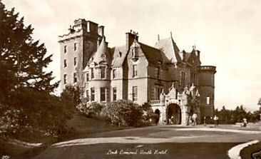
Auchenheglish
Auchenheglish House, “the field of the church”, was originally called Auchendennan Rhie or the “King's Auchendennan”, all three Auchendennans being part of the hunting estate of the King Robert the Bruce. It was owned in the late 19th - early 20th century by the Brock family who donated the old Bromley or the Henry Brock Hospital, to the people of the Vale.
In 1938 Sir Cargill McCowan bought it and in the early 1960's his son David converted it into the luxury Lomond Castle Hotel. The Hotel was very successful for many years, but after David McCowan disposed of it, it went into an economic decline. In 1990, its final owner as a hotel arranged to have it burned down, and was duly jailed for his troubles.
The old stables adjoining the A82, had been converted into a leisure centre, but it too closed and also burned down at a later date. The ruins of both buildings stood derelict for a number of years, but a very successful holiday lodge and restaurant complex operated around them. However in the mid 1990's, the Hotel ruins were rebuilt into luxury flats with the old Auchenheglish façade still quite recognisable. Similarly, the conversion into flats of the old stables / leisure centre building is nearing completion (January 2008).
Auchincarroch Road
“Hackenkeroch in the parish of Buthelulle” first appears in a charter of the Earl of Lennox in the year 1270, when he grants the land to the church at Glasgow, so it is one of the earliest documented lands in the Vale. “Auchin” and “Auchen” are interchangeable in the spelling of this road which runs from Main Street Jamestown, at the end of Milton Terrace, in an easterly direction for a couple of miles to the Merkins Farm, where the name ends, though the road doesn't.
The through road turns sharply left or northwards to Caldarvan. Auchencarroch is the southern leg of the “Horseshoe” described elsewhere. The various farms on the road confirm the origin of its name “Auchin” denoting an uninhabited agricultural piece of land, such as a field, from the Gaelic, “achadh”. The “carroch” could be a person's name, but there are also at least three Gaelic possibilities - rocky (from “carraig”), having an uneven surface (from “carrach), and an erect stone such as an ancient standing stone (“carragh”).
The Scottish Ordnance Gazetteer of 1884 and its 2nd edition of 1892-6 both say that there is an Auchincarroch estate and mansion. Their maps suggest that it was where Auchincarroch farm now is, so perhaps there was a mansion on the site, but more likely it was an older farmhouse. “Auchinarkies” is land mentioned in the Partition of the Lennox, but it is not certain that this refers to Auchincarroch. The “carroch” part of the name appears again, of course, in the Carrochan Burn, and while both refer to the same derivation, it is not known what it was.
![]()