Loch Lomond Villages - West
Arden - Luss - Inverbeg - Tarbet - Arrochar - Inveruglas - Ardlui
ARDEN
 This rural community, about 2 miles north of Balloch on the A82, is centred on the roundabout on the A82 that now bears its name. Arden is about 4 square miles in area and lies partly in Bonhill and partly in Luss parishes.
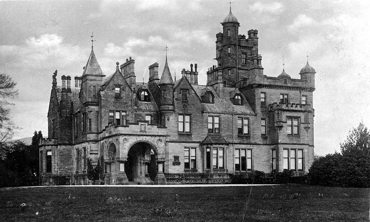
Considering that it contains so many estates and farms, it is perhaps surprising to learn that the name “Arden” has no intrinsic meaning, and is of comparatively recent origin. It is named after the mansion called Arden House, which stands close to the roundabout, on the shores of the Loch, and which has now been made into flats.
Until shortly after 1770, when it, and the nearby Bannachra estate, were acquired by a Glasgow merchant George Buchanan, it was called Auchendennan Dennistoun. Perhaps because there were two other houses close by, which also had Auchendennan in their names, Buchanan changed the name of the house to Arden House, and the hamlet followed suit over the years. The Buchanan family sold Arden and Bannachra to the Lumsdens in 1864. The Lumsden family, perhaps best known latterly for their connection with Burmah Oil, continued in residence at Arden House until the 1980's when it was sold and converted to flats.
 The Lumsden family home became Bannachra, but that too was sold in 2003. Until Buchanan renamed Arden House, the area had been called the “Red Hoose”, after the Red House, a two story building which stood at the junction of the Black Hill road to Helensburgh and the A82. Indeed, the locals referred to Arden as the “Red Hoose” until well into the 20th century.
The Red House, and an adjacent small building which housed the post office, were demolished in the 1980's to make way for a series of road improvements, which culminated in the creation of the Arden roundabout on the A82. The roundabout is now probably Arden's best-known feature, largely because of the name checks it gets on radio traffic programs.
In the summer of 2007, De Vere Hotels opened a new Lochside golf course, the Carrick, which lies mainly in Arden, with the first hole at Burnfoot, and the much of the rest of the course on the north side of the Fruin on the old Mid Ross farmlands.
Click on the images to enlarge in a new window
LUSS
 Luss - from Gaelic “lus” for herbs, or French for a lily (“luce”) or fleur-de-lys - has a long archaeological, ecclesiastical and anecdotal history certainly going back to early Christian times. Luss is not only a village, but also a parish and the parish includes the islands of Inchlonaig, Inchtavannach, Inchconnachan, Inchmoan, Inch Galbraith and Fraoch Eileann.
The parish church and churchyard have a number of archaeological mementos, probably from the 7th and 8th centuries. These include stone carvings and statues of perhaps St Kessog, perhaps not, and a Viking gravestone, as well as one of the earliest Christian gravestones in Scotland. That Viking gravestone could date from the Loch Lomond Viking raid of 1263, immediately prior to the Battle of Largs, when Vikings pillaged the whole Lochside. There were earlier Viking visits, and it is possible that the stone dates from one of them.
 St Kessog was the leading Celtic saint in the old Lennox, and even Robert the Bruce held him in such high regard that he declared an area around Kessog's old chapel at Luss as a girth (a sanctuary where a person could not be arrested). It is no longer clear where that chapel was but there is a record dating from 1430 of Luss Church, and the remains of that church can be seen in to-day's churchyard.
A new parish Church was built in 1771 on the site of the present one. The present was erected in 1875 in memory of Sir James Colquhoun who was drowned in December 1873 with four ghillies while returning from a deer shoot on the island of Inchlonaig. There is a memorial stone in the churchyard containing their five names.
Perhaps surprisingly in a parish where the laird had such an upper hand, a breakaway Free Church was built at the Bandry after the Disruption of 1843. While its congregation reunited with the Church of Scotland in 1929, it continued to operate as a separate Church until 1940, when its minister of 57 years died. It was then closed and converted to a house, but its previous life as a church is clear to see.
Perhaps we should not be surprised at the disruption in Luss, because the laird's wife and his brother were two of the disrupters, but that was untypical of the landowning class at that time. Luss is inextricably linked with the Colquhoun clan, the chief of which has styled himself “Colquhoun of Luss” since the 14th century. Until very recently, Colquhoun of Luss owned the whole of the Parish of Luss, except the estate of Bannachra, and they remain one of the largest landowners in the west of Scotland, through their company Luss Estates.
 The clan chief now lives at Camstradden, but before that, of course, the Colquhoun's primary residence was on what is now Loch Lomond Golf Course, at Rossdhu House. It was built in 1773, and replaced a 15th century castle, which lay close by. Lying on the borders of the Highlands made life exciting for the people of Luss, because they were frequently called to arms by the clan chief (“the fifty men of Luss” make frequent appearances in contemporary reports of dealing with the McFarlanes and McGregors) to tackle their neighbours' incursions.
The McFarlane and McGregor clans had a much more relaxed view of the principles of property ownership than the Colquhouns, and even when not in a formal call out, they regularly had to resort to violence to drive off raids on their cattle and crops. Occasionally, things took a turn for the worse, such as in 1603 when 140 Colquhouns were killed at the battle of Glen Fruin - the McGregors and McFarlanes maybe lost 2 men.
A very good case can be made that on this occasion, the Colquhouns brought it on themselves, because they killed two McGregors, having already refused them traditional Highland hospitality. In any case, in the Battle of Glen Fruin, the last purely clan battle fought in Scotland, the Colquhouns outnumbered the McGregors and their McFarlane allies almost 2-1, and really should have done better.
In 1715, supposedly as part of the Jacobite rising of that year, the McGregors, led by Rob Roy, twice raided Luss. The first time was as part of the Loch Lomond Expedition in October 1715, but they returned in December when they attacked Rossdhu, and even robbed the parish minister, who would have certainly have been anti-Jacobite, but much more importantly, in possession of some funds. That was the last hurrah of McGregor attacks on Luss and the lands of Colquhoun, although no doubt petty thieving continued.
After the 1745 uprising peace descended on the area. So also, unfortunately, did black-faced sheep. This breed of sheep was more profitable than existing breeds, and was introduced by Colquhoun of Luss to Glen Mollachan at the head of Luss Glen in 1747. This began the clearances - a slow, inexorable process with farms being shut and farmers moved off the land in the glens around Luss.
In part, the Colquhouns recognised their responsibilities - in 1776 they laid out Helensburgh, where they started a textile works to employ former tenants, and in 1790 a cotton mill was opened in Luss itself. Also, nature stepped in to help, with the opening of Luss Slate quarries in the 1770's / 80's to provide slates for the roofs of the burgeoning central belt towns. The quarries had closed by the 1930's, but there are still many houses in the Vale with Luss slates on their roofs.
Ironically perhaps, when Dorothy Wordsworth passed through Luss in 1803, on her tour to the Trossachs, it was the first place in Scotland where she saw turfed roof buildings, and with people on the road wearing kilts.
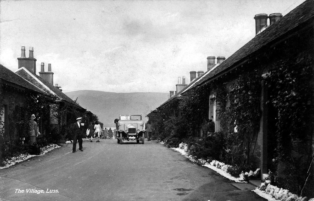
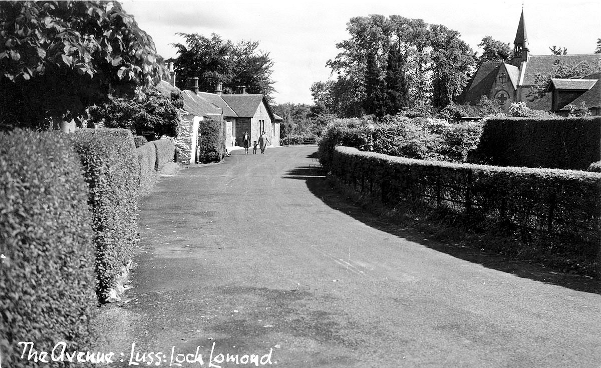
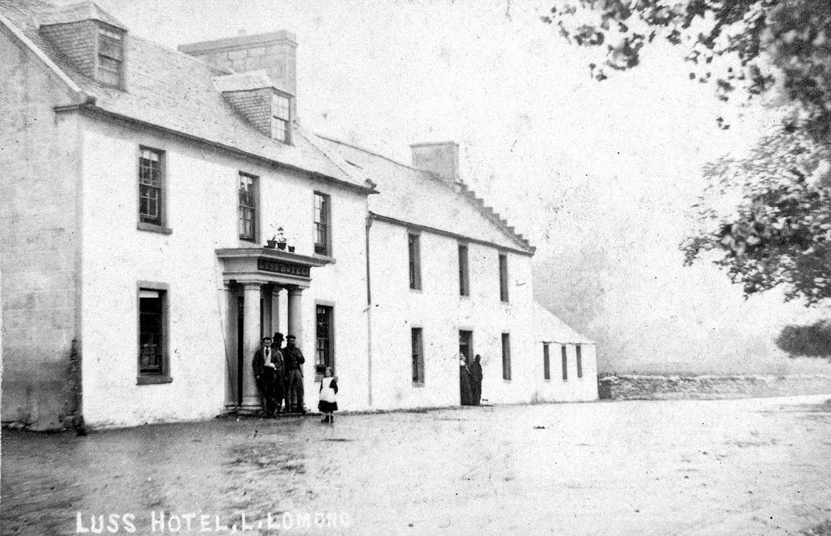
 The roads and houses, which now constitute the very picturesque village of Luss, were nearly all built in the early 1800's by Colquhoun of Luss, to house the workers in the mill and the quarries. The old houses were largely renovated in the early 1990's with the official re-opening in 1992. The pier at Luss was built about 1845, and from the about 1860 until 1902, when a slip way was built at Balloch, the Loch steamers were drawn out of the Loch for inspection on a slipway located just about where the Lodge on the Loch hotel now stands. Until the 1960's the stumps of the jetties at this slipway still jutted out above the waters of the Loch.
With the drop off in passengers using the steamers and piers, Luss pier closed in 1952, the first of the Loch piers to close. Since this was the year before the Maid of the Loch came into service, the pier owners, the Colquhouns, didn't even wait to see if the new and larger steamer would boost the revenues from pier dues. They could claim some prescience in this, since the Maid's passenger loads were in a gentle downward trend, even if some years were better than others. However, there was much pressure from the tourist industry, heritage groups and boating enthusiasts for the restoration of the Loch piers to a usable state. A restoration program for most of the piers was implemented between 1978 and 1983, using public money, and Luss pier was rebuilt in the late 1970's.
It was substantially remodelled to handle modern needs, and re-opened in 1980. This was just in time for the Maid of the Loch to be able to call at it for the first time in the Maid's nearly 30 years of service. Ironically, on one of its first visits, it ran aground on a sandbank, which had developed just off the pier in the intervening 30 years, and had to be towed off by John Sweeney's boats from Balloch, including the Skylark.
By the end of the 1981 season, the Maid had gone, but the Pier survived to be used by the Countess Fiona until it, too, stopped sailing in 1989. Since then the pier has been well used by a succession of cruise launches which take tourists around the nearby islands, and also by other Loch boat owners.
For the last 20 years or so, the Luss Rescue Boat has been based a few yards south of the pier, close to the corner of the churchyard. In 2006, Princess Anne presented the 20 or so volunteers who provide the rescue service for all Loch and Leven users, with a new £105,000 Rigid Inflatable, the St John - named after the charity which provided the funding for the boat.
Sir James Colquhoun initiated the Luss Highland Games in 1875, in what is perhaps the most picturesque of the many picturesque settings for Highland Games throughout Scotland. Until quite recently, the Games were held on the first Wednesday of the Glasgow Fair in July, but in the last few years they have moved to the previous Sunday, so as to immediately follow the Balloch Games, which are held on Glasgow Fair Saturday.
It was the beauty of the village and the surrounding scenery, which attracted Scottish Television to base their Take The High Road soap in Luss (known in the program as Glendarroch). The program was made around Luss from 1980 until it stopped production in 2003 - although it continues to be shown somewhere in the world every day.
Luss has probably never been busier, and it has a year-round stream of visitors. Even the church is a tourist destination in its own right - it has proved a very popular wedding venue. The Church has also been very innovative in its use of the Internet for services and pastoral matters. Conventional tourism is booming as well in Luss, with a new hotel, The Lodge on the Loch, opening in the early 1990's, and a couple of good tea room / restaurants deservedly doing a brisk trade.
Click on the images to enlarge in a new window
INVERBEG
 “Inver” has the same meaning in Gaelic as “Aber” - where 2 rivers meet, or where a river flows into the sea or a Loch. Inverbeg should therefore mean “where the river Beg flows into the Loch”. Except there is no river Beg, it's the Douglas water that flows into the Loch at Inverbeg, Inverbeg being at the eastern end of Glen Douglas.
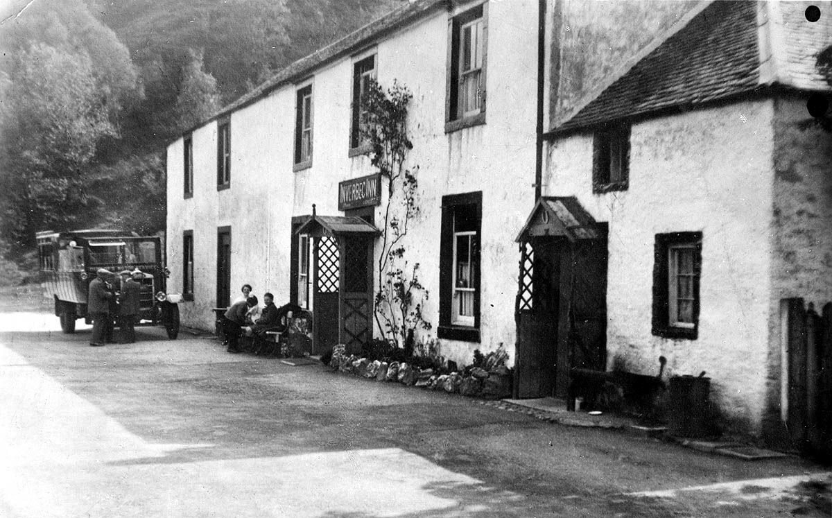
There has been an Inn and ferry at Inverbeg for many centuries, although the present Inn building dates from 1885. At one time the ferry route, although not the ferry itself, was used as a short for cattle from Argyll heading to-wards Falkirk. The drovers swam their cattle across Loch Lomond from Inverbeg to Rowardennan, from where they headed down the east side of the Loch towards Drymen or across the hill tracks to Crieff.
The drovers crossed by boat. Swimming the cattle across the Loch was not an easy task, and specially trained cattle were kept at Inverbeg to lead the ones being driven. These cattle, which had made the crossing many times, were kept in a field next to the ferry, probably where the caravan site is now.
Close to the Inn, just in Glen Douglas and no more, there used to be a small Youth Hostel but this was closed about 30 years ago. Inverbeg Inn became very busy with walkers, caravaners and sailors from the late 1960's to the 1990's, under the popular ownership of Jack Bisset.
A small harbour for pleasure boats was built there in the 1980's to provide safe anchorage for the greatly increased number of boats calling at the Inn. When Jack left the Inn, it went into a pretty sharp decline. However, it has just changed hands again (November 2007), having been acquired by the Colquhoun family, owners of the nearby Lodge on the Loch, who plan to refurbish it for the spring of 2008. This will no doubt be welcome news to the users of the extensive caravan park just across the A82, as well as patrons of the adjoining Art Gallery.
TARBET
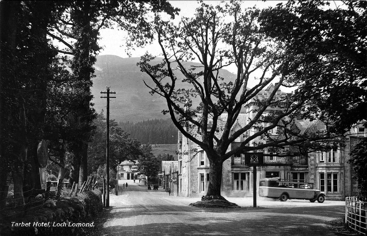 This Lochside village lies at the junction of the A82 and the A83, about 16 mile north of Balloch by road, and about a mile and a quarter east of Arrochar and Loch Long. The name is Gaelic for an isthmus or portage point for dragging boats from one stretch of water to another across a narrow strip of land. “Tarbert” is just another spelling from the same origin, and indeed the first written record of Tarbet is in 1392, when it is spelled as Tarbert.
Its location as a road junction, portage point, ferry crossing (to Inversnaid in the old days) and later railway station and steamer pier, ensured that Tarbet has seen a lot of visitors over the centuries. Perhaps the most notorious were the Vikings who passed through Tarbet coming from Loch Long to raid Loch Lomondside in 1263, immediately prior to their defeat at the Battle of Largs. While there had been previous Viking sorties onto Loch Lomondside via Tarbet, this was by far the most significant and best known.
Even by 1263, the area around Tarbet already belonged to the forerunners of the McFarlane clan, while immediately to the south lay the McMurrichs' lands (the McMurrich name later took many forms including McCurrie and Currie). The McMurrichs got on well with the McFarlanes, and they seem to have had the good sense to avoid conflict with the McGregors, unlike their much more powerful immediate neighbours to the south, the Colquhouns.
The McFarlanes originated as a branch of the Earls of Lennox through a younger brother, who was given the lands of Arrochar about 1225 –30. His descendants went on to be called Parlan (still a common name, as Parlane, on the Gareloch and in the Vale), which in turn became McFarlane.
The McFarlane lands of Arrochar were sold in 1785, and the direct male clan chieftain line expired in 1866. However, in the intervening 400 or so years the McFarlanes were a force to be reckoned with. Tarbet was towards the south of their lands - their war cry “Loch Sloy” gives a good indication of the geographic centre of their territory. An early chief was a friend of Robert the Bruce, who at one stage had to hide at the northern end of Loch Lomond from his enemies, and this loyalty to the Stuarts remained until the time of James II in1685.
The McFarlanes were close allies of the McGregors just across the Loch, and like them, the McFarlanes stole cattle from their neighbours - so much so that the moon was known as McFarlane's Lantern. Their neighbours happened to include the Colquhouns of Luss, whose lands lay just beyond those of the McMurrichs to the south, and they were every bit as much the McFarlanes' sworn enemies as they were the McGregors.
 A typically cheeky raid by the McFarlanes on the old Rossdhu Castle in 1592 - they stole the castle gates no less - generated a reference to an Inn at Tarbet, and it is thought that there was probably some form of Inn there from at least 1570. In 1592, the McFarlane chief had just dropped off the stolen gates at his nearby watch tower at Tighvechtichan (about half between Arrochar and Tarbet, at a point from which you could see both Loch Long and Loch Lomond) and was having a celebratory drink in the Inn, when he saw a Colquhoun war party approaching, hell bent on vengeance and recovering the gates. He laid aside the drink just long enough to ward off the Colquhouns.
The McFarlane chiefs had castles on a number of the Loch's northern islands, which was just as well. Their loyalty to Stuarts cause during the Civil War cost them their castle on Inveruglas Isle, which was attacked and burned by Cromwell's troops in 1654. Although some of Inveruglas castle still stands, the McFarlane's never lived there again. Instead in 1654 they moved to another island castle, on Ellan Vhow, which they had had the foresight to build in 1577.
Before the end of the 17th century, they had both broken with the Stuarts (in 1685), and moved in 1697 from their island castles to one on the mainland at Arrochar, more or less where the Claymore Hotel now stands. They therefore played no part in the Jacobite uprisings of 1715 and 1745, and were only spectators at Rob Roy's Loch Lomond Expedition of 1715. In their retaliatory sally, the Crown's forces used Tarbet for a couple of days as their base against Rob Roy's fastness at Craigrostan, just across the water. In the event both sides declared themselves the winners, and the McFarlanes were left undisturbed.
In 1785 they sold their lands of Arrochar to the Colquhouns of Luss. The Highlands became more law abiding as the 1700's wore on, and it became safe to drive cattle through McFarlane and McGregor territory from Argyllshire and the southern Hebridean islands. Some of these drives passed through Tarbet heading to-wards Glasgow's market, and after Falkirk Tryst replaced Crieff as the main Scottish cattle fair in 1770, many of the drives heading to Falkirk also came through Tarbet.
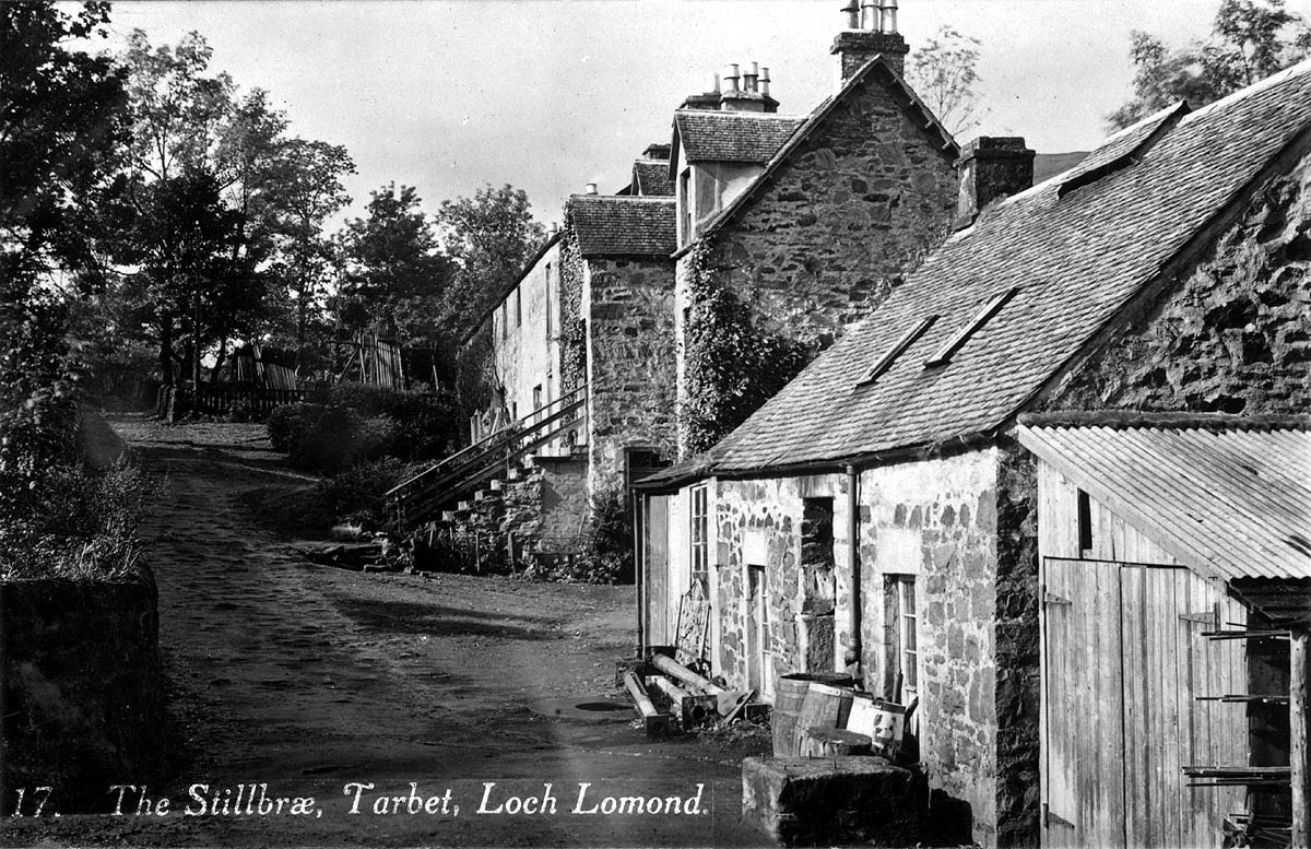
It was also about this time that a distillery was started in Tarbet, at the appropriately named Still Brae. Some of the old building is still standing and dates from about 1735 and 1745. All of the whisky was shipped out by sea, since there were more than enough local illicit stills up and down the Loch, to meet local needs. Tarbet distillery relied on bottles produced at Dumbarton glass works, and only closed after the failure of the glassworks in 1830, a victim of high taxation on its main product, window glass.
As one door closed another opened, and Tarbet was also ideally placed to take advantage of the growth in tourism to the increasingly placid Highlands. This was particularly true after the building of the military road up the Lochside, westward to Inverary and beyond in 1746 - 48, and then northward from Tarbet through Glen Falloch in 1752 - 60. Now “growth” and “Highland Tourism” were very relative terms in those days, because any increase at all was from a base of nobody, or at least, nobody in their right mind. But by the 1760's a trickle of intrepid travellers was coming from the south, including Boswell and Dr Johnson who passed through Tarbet by coach en route from Inverary to Rossdhu in 1773.
 Robert Burns not only stayed in Tarbet Inn in late June 1787 on the way back from Inverary, he also wrote a poem to the landlord's daughter there. Poets William and Dorothy Wordsworth and Samuel Taylor Coleridge stayed at Tarbet Inn in 1803, en route to the Trossachs, and crossed from Tarbet to Inversnaid by ferry, which was by this time a busy enough route into Craigrostan and Loch Katrineside.
The great road, canal and bridge builder, ThomasTelford also stayed at Tarbet Inn in 1819, whilst on a tour with his friend, the poet Robert Southey. The Wordsworth visit shows that Gaelic was still the prevalent language around Tarbet in the early 1800's - Dorothy thought that the landlord's family's lack of communication was surliness, but in fact they were native Gaelic speaker with only a little understanding of English, and no understanding at all of an English accent.
After pleasure steamers started sailing on the Loch in 1818, Tarbet became a stopping off point and this generated more tourists. At about the same time, steamer services started on Loch Long. To begin with, the Loch Long steamers' focus was on Loch Goil, as part of a Glasgow - Lochgoilhead - St Catherine's - Inverary route, and sailing all the way to Arrochar was comparatively rare. However, this soon changed and certainly by the 1820's and 30's, there was a regular summer steamer service from Glasgow, then Helensburgh (and after 1882, Craigendoran) to Arrochar, which became an all the year round service.
The potential for a sail on the three Lochs - Loch Long, Loch Goil and Loch Lomond with a brisk walk or carriage ride between Loch Long and Loch Lomond - was spotted early on, and this also increased visitors to Tarbet. However, in the early 1840's the lack of Lochside piers caused the worst single loss of life on Loch Lomond, when a small rowing boat, of the type used at all stops to carry passengers from the steamer to the shore, capsized while unloading passengers at Tarbet and 11 passengers were drowned.
This accident hastened the building of piers around the Lochside, and Tarbet pier opened for business in 1846. Which was just as well, because in 1845 toll roads had been introduced to allow local landowners to charge for road usage, and the Colquhouns surrounded Tarbet with tollbooths. The whole toll concept was, of course, a nonsense, since the major road users were in fact the local landowners themselves - very few other people were in a position to make use of the roads, but when they did they had to subsidise the landowner.
One group who had used the roads were the cattle drovers, but they had alternatives, and in any case didn't particularly like the new military roads, which were sore on the cattle's hooves. Around Tarbet, the drovers simply took to the hills, bypassing Tarbet completely, so the steamer trade was very welcome. On the road during the summer months, a three day a week coach service ran between Tarbet and Inverary. It left Inverary in the morning and returned from Tarbet in the afternoon. Coaches were also available to carry passengers between the Tarbet and Arrochar steamers.
The former church building close to Ballyheenan Burial Ground was built as a Free Church in 1844, following the Church of Scotland Disruption of the previous year. The Burial Ground dates back to “time immemorial” and in a reversal of the usual order of things, the Church arose beside it, rather than the other way round.
An early visitor to the pier was the Prince Consort, Albert, who landed at Tarbet in 1847. Queen Victoria and Albert were great lovers of the Scottish countryside and had a number of trips on the Loch, usually setting out from Inversnaid, but in 1875, Queen Victoria passed through Tarbet en route from Inverary en route to catch the Royal Train at Balloch. It was probably the Queen who encouraged another royal visitor, the Emperor of Brazil, Pedro II, to stay on the Lochside, at Tarbet Hotel, around 1871 - he had been on a visit to the Queen in London at that time.
Being very religious, on the Sunday of his stay at Tarbet, the Emperor drove down the Loch shore road in his coach to Alexandria, to attend services at Our Lady and Saint Mark's, the nearest Roman Catholic Church. It must have been quite a contrast with cathedrals and ornate private chapels in which he usually worshipped.
It was a few years after this, in 1882 that Tarbet Hotel took on its present Scottish baronial appearance, although it also took on the name the Colquhoun Arms for a time.
 In October 1889 the building of the West Highland Railway began, the last great railway building project in the UK until the Channel Tunnel, and given the technology available, just as difficult. The approach to the build was to conduct simultaneous construction from 5 base camps, with overall control being exercised from a headquarters at Helensburgh. While Tarbet lay between two of these camps - at Arrochar and Inveruglas - it has a significant place in the treatment of the 5,000 navvies who worked on the construction, with at the peak of construction 1,000 navvies in the immediate Arrochar - Tarbet - Inveruglas area.
Firstly, 37 of the men who were killed during the 5-year build, were buried at Ballyheenan, although not in the Burial Ground, but just outside it. No record has been left of why the graves weren't actually in the Burial Ground, and it is easy to speculate why this was so - fear of the outsider, religious differences etc, but other evidence points to that not being the case.
At the beginning of the project, almost all of the navvies were Irish, but progressively more Highlanders joined the work, although few could have been local. Nonetheless, they were very well accepted by communities along the whole length of the line, and nowhere more so than at Tarbet. There the local minister, Reverend Elder, of the Free Church at Ballyheenan, not only built a reading room and canteen in the church glebe, for the use of the navvies, he also provided coffee at any hour of the day, to any navvy, regardless of religion. We wouldn't hold our breath waiting for that hospitality to be matched to day.
Having welcomed the workers into their midst while they were alive, it seems most likely that the local inhabitants, faced with so many burials in such a short space of time, worried that the Burial Place would fill with railway workers, and that there would be no lairs left for them when their time came - an understandable sentiment for the times. In 1996, a local community group unveiled a memorial stone at the Burial Ground to those railway workers who are buried there.
When the railway opened in August 1894, Tarbet gained a railway station, called Arrochar and Tarbet, but definitely located in Tarbet, it also gained even more tourists. An additional variant was added to the existing three Lochs Tour, so that instead of sailing to either Arrochar or Tarbet and walking (or taking a horse-drawn coach) between the two, the tourists could now take the train to Arrochar and Tarbet and catch a steamer either on Loch Long or Loch Lomond.
The growth of road transport also brought many additional visitors to Tarbet, particularly after Dunbartonshire's main roads were all tarred for the first time in 1923-4, making the Glasgow-Balloch route one of the busiest in Scotland at the time. Unfortunately, the tarring of the road was about the last major positive development on the A82 north of Tarbet - and that was over 80 years ago.
Although the stretch of the A82 south of Tarbet has seen many improvements over the years, particularly in the late 1980's and early 1990's, the road between Tarbet and Ardlui remains one of Scotland's national embarrassments. Far from being improved, it has both been allowed to deteriorate, with poor drainage and crumbling road surfaces, and actually made worse with the installation of a traffic light to control a short stretch of single carriageway where part of the verge fell into the Loch - in the mid 1970's. This gives that stretch of the A82 the very dubious distinction as being the only trunk road in the UK which is reduced to a single track controlled by a traffic light. It also means that to many drivers, Tarbet is where the decent road ends.
 Towards the end of the Second World War, Tarbet was again impacted by a major civil engineering project - the building just up the A82 of the Loch Sloy Power Station. Building started in April 1945 before the war actually ended, and the Power Station was opened by the then Queen in October 1950.
As well as the Power Station, in 1949 - 50 the Hydro Board built a new small housing estate at Ballyheenan Crescent of about 30 houses for staff at the Power Station, and this remains the last major increase in the size of the village. In 1947, the Free Church in Tarbet re-united with Arrochar Parish Church, and remained open under one minister. However, it was finally closed in 1966, and has passed through a number of hands and a number of names since then, usually as a café / restaurant, now called the Ben Lomond.
By the 1970's, increasing affluence had greatly reduced tourist cruising on the Loch steamer, the Maid of the Loch, and revenues at privately owned piers were insufficient to cover the costs of maintenance and repairs, never mind make a profit. Many Loch side piers closed, including in 1975, the one at Tarbet. However, a five year program of pier redevelopment was announced in 1978 by local authorities, aided by central government agencies, and a new pier, reduced in height, and more flexible in its use and availability to all Loch craft, eventually re-opened.
In 1984, the Countess Fiona, which had replaced the Maid of the Loch in 1982, once again started calling at Tarbet pier. This proved to be a short lived arrangement, because the Countess Fiona stopped sailing in 1989 and was not replaced. However, by then a local company based at Tarbet, Cruise Loch Lomond, had started shorter cruises from the pier. Cruise Loch Lomond has met the modern tourist need, and handles the modern tourists requirements on a year-round basis.
In terms of people passing through, Tarbet has never been busier. The new stretch of road to the south has improved travelling time and made the road much safer. Tarbet has come into the commuter belt to Helensburgh, the Vale and Glasgow, as evidenced by the rise in house prices, and just a few years ago gained the requisite commuter accessory - early morning commuter train to the big city. The 7.08 a.m. train for Glasgow Queen St starts from Arrochar and Tarbet station, with a matching return train in the evening.
What goes around comes around, and its a throw-back to the old push-pull train to Craigendoran of the 1950's and 60's, which along with a number of Garelochside stations became a victim of Dr Beeching.
Click on the images to enlarge in a new window
ARROCHAR
Although Arrochar is not a Loch Lomondside village, it has been so closely linked to Tarbet and Loch Lomond over the centuries, that it would be pedantic to exclude it.
There are 2 choices for the derivation of Arrochar, neither of them very elegant. Firstly there is “aratrum” which had an ancient Scots meaning of Ploughgate or the amount of land 8 oxen could plough in a year, which was regarded as 104 acres. Its quite plausible that the original hamlet might been based on such a term because the wording in the document by which The Earl of Lennox bequeathed the land to his son in 1225 was “the upper Arrochar of Luss”.
The second possibility is that it is called after a local hill, which an early map calls Ben Arrochar, “mount sheiling-dark” in Gaelic. The hill and the darkness seem even more plausible. However, Arrochar as a name had a pretty low profile for centuries, and even into the 19th century the hamlet, as it then was, is sometimes referred to as “West Tarbet”, or spelled “Arroquhar”, depending who is writing. However, its location at the head of Loch Long, at the western end of a narrow, one and a quarter mile land link between the sea loch and Loch Lomond, meant that it saw a lot of coming and going over the centuries.
Best known, of course, was the Viking raid of 1263, when immediately before their decisive defeat at the Battle of Largs, King Hakon's men set out on an early version of the Glasgow Fair Three Lochs Tour of pillage, plunder and mayhem, which wouldn't be repeated for another 600 years.
A small farming and fishing community grew up around the head of Loch Long and in the surrounding glens. By 1648 the population had grown sufficiently for the McFarlane chief of the day to petition Dumbarton Presbytery to create a separate Arrochar Parish out of the existing Luss one. The actual aim was to get a local church built, to save the McFarlanes a 10 mile each way walk through the hills each Sunday, in what is still just about the wettest part of Scotland (in those days there was only one church to each parish). With what was lightening speed for those days, the separate Arrochar Parish was created in 1659.
The parish included the northern end of Loch Lomond - Tarbet, Ardlui etc and was quite a big stretch itself. However, normal ecclesiastical torpor soon re-established itself, and a church was not actually built for another 70 years or so, in 1733, on a site within a few feet of where the present church stands. The present church was built in 1847, but by 1998 the building had deteriorated to such an extent that it was deemed unsafe to enter it, and it looked to be heading for demolition. However, the community rallied round and in 1999 it re-opened for a range of community based uses, including, of course, being the Parish Church.
The Roman Catholic Church in Arrochar was, appropriately, opened on Christmas Day 1952. Going back three centuries, the McFarlane clan chiefs had tired of island living on Loch Lomond, and in 1697 they moved to Inverioch in Arrochar - where the Claymore Hotel (perhaps better known as the Cobbler Hotel) now stands. The McFarlane chiefs were not in Arrochar for long, because one of them took up the dishonourable role of an absentee Scottish landlord, and on his death his heirs sold the McFarlane Arrochar lands in 1767.
The Inverary - Dumbarton military road was built through Arrochar in 1746 - 48, and on went along the west side of Loch Long and into Glen Croe. Over time, the road did bring more visitors through the area. It is said that Burns visited a croft called Knockerbus on Highlandman's Height on the west side of the Loch, during his journey back from Inverary in 1787. However, it was really the arrival of the steamboat, which generated noticeable change in the way of life in Arrochar.
By about 1820, there were steamers plying their trade on Loch Long. However, initially they were sailing from Glasgow to Lochgoilhead for onward overland transport to St Catherine's and the ferry to Inverary - a much quicker journey than by coach. They were soon (within a year or so) joined by a Dumbarton steamer, which sailed to Arrochar as part of a Three Loch Tour - Loch Long, Loch Goil, cross to Tarbet and Loch Lomond. Then on by steamer to Balloch, from where a coach took the passengers back to Dumbarton for connections to other Clyde ports.
This Three Loch Tour was a feature of Clyde steamer cruising, which was to last for another 150 years, and only stopped when swingeing cuts were made in Clyde steamer services in 1972 and the piers at both Craigendoran and Arrochar were closed. However, at this stage Arrochar pier hadn't even been built yet, and wouldn't be until 1850. The New Statistical Account of Scotland of 1839 paints a picture of Arrochar of not just a farming community, but also a fishing one as well.
Although neither as plentiful nor as busy as Loch Fyne, Loch Long did have some very good herring years and in the 1830's there were 23 men engaged in fishing. It was a busy little community, with the daily Inverary - Dumbarton post meeting at the head of Loch Long to swap the mails. Arrochar is equidistant between the two towns at 22 miles in either direction - and the postmen walked these miles.
In the 1830's the first Inn opened at Arrochar, and shortly afterwards, Tarbet and Arrochar could between them boast another 5 public houses. According to the local minister of the time they “have a most pernicious influence”. Well, he would think that wouldn't he?
Presumably, it was the reputation of the Three Lochs sail rather than a wish for a pint in any of the “pernicious” pubs, which brought Queen Victoria up Loch Long to Arrochar in 1849 on the Royal Yacht. The Queen certainly intended to go ashore, but as luck would have it, it was raining as only it can in Arrochar, and she sailed away again without landing. She might have landed had the pier been open, and when it did open the following year, there was a measurable impact on Loch Longside.
There began a regular steamer service, initially from the Broomielaw in Glasgow, but after about 1863 from Helensburgh, and then when Craigendoran Pier opened in 1882, from there. This steamer made it possible to commute to Clydeside businesses - the train was by now at Helensburgh and later Craigendoran, but it was another 44 years before services began to Arrochar and Tarbet station.
Some Clydeside merchants started to commute by early morning steamer from Arrochar. Not many of, course, but it didn't take many to make an impact on the local economy. New houses started to be built on the Lochside at Arrochar, many of which are still there, although much altered. Arrochar was served by a series of steamers called the Chancellor, and by 1892 had three daily sailings. They survived the coming of the West Highland Railway, because they were the only direct line of communication between many of their ports of call such as Lochgoilhead, Ardentinny and Kilcreggan, and indeed the direct service they provided can't be equalled to day.
They also ran right through the First World War, which closed down the Gareloch steamer services, (because the Gareloch was closed to all but Royal Navy ships for the duration). It was the advent of the motor car and bus which finished them, the last sailings being in 1972 when a three times a week Three Lochs Tour called at Arrochar.
The pier then closed, and unlike the piers on Loch Lomond, there was insufficient pressure to modify it for more modern use, which still seems a bit strange. But the steamers had made their mark, because by the final years of the Victorian era, tourism was well established in Arrochar. It now had two hotels - Ross's Hotel which became the Loch Long Hotel, now much extended and altered, and the already-mentioned Arrochar Inn, which by this time had changed its name to the Arrochar Hotel, but already occupied its prime position at the junction of the old military road and the road to Garelochhead, which had been built at the Duke of Argyll's expense in 1777.
There was also a number of private hotels and boarding houses. On the site of the old McFarlane clan seat, a Victorian mansion, Inverioch House, had been built and later in the twentieth century it too was converted to a Hotel, becoming firstly the Cobbler, by which name it is still best known to locals, and then the Claymore.
The building of the West Highland Railway between 1889 and 1894 provided Arrochar with something like boom times. Arrochar was one of the five bases from which the simultaneous construction of the line was carried out. Men and materials could easily be brought in by boat, and the line was never far from the water. At its peak, there were about 1,000 navvies working on the Arrochar section and a force of 6 policemen was required to control them on a Saturday night.
While the railway hardly brought riches beyond the dreams of avarice to the Village, it has brought a steady stream of visitors. Initially they came on a variant of the Three Lochs Tour - with the rail journey along the Gareloch and then Loch Long substituting for the sail on Lochs Long and Goil. Then more recently, an increasing number of climbers have come to spend a day or two on the Arrochar Alps. And even more recently, commuters to and from Glasgow have started to travel from Arrochar.
In 1908, a new Loch Long user appeared in Arrochar - the Admiralty. As part of its torpedo manufacturing strategy, the Admiralty started to build a testing range for torpedoes, close to its new torpedo-manufacturing factory at Greenock, which opened in 1910. Only the width of the Clyde and the length of Loch Long separated the two, so it was pretty sound strategy, which actually stood the test of time. The range opened in 1912 and in the 75 years or so it operated until its closure in December 1986, it provided a very useful 70 or so “bread and butter” jobs in Arrochar.
In that time, each and every torpedo which was going to be delivered for active use by a Royal Navy submarine or ship, had to be test fired down the Loch long range. Each torpedo was fitted with a dummy nose cone in place of the explosive, and fired from torpedo tubes at the base, to be caught in nets at various points down Loch Long. During the Second World War, especially, the performance at the base was very impressive by any standards: in 1944 approximately 12,565 torpedoes were fired down the range, an average of 48 runs per day.
Over the years, the vast majority were recovered successfully and sent out on active service. A very small proportion sank to the bottom of the Loch, from where they were retrieved by divers. Of course, there was periodic light relief, hushed up, but passed on by word of mouth by the many eyewitnesses to things, which did not go quite according to plan. A couple of examples will suffice. In the 1950's, the range had the distinction of torpedoing a Clyde steamer, the Countess of Breadalbane, as she approached Arrochar on a Three Lochs cruise. No damage was done, although by all accounts the steamer's captain was very unimpressed.
His message obviously got through, for the steamer fleet was thereafter left alone, and the torpedoes sought out more static targets instead. One, which was fired at the height of the Vassall and Kroger spy scandals in the Admiralty, had clearly been nobbled by the Russians. Not only did it take sharp turn to the left immediately after firing, (which MI5 would still regard as showing dangerously subversive signs) it was by then tracking in an easterly direction, no doubt heading “home” to Moscow.
It never quite made it, falling short by a couple of thousand miles. Instead, a few hundred yards south east of the Range, it ploughed up a beach in front of what was then a Lochside hotel, cut a swathe across the lawn and spectacularly crashed through the French windows of the hotel. While this no doubt spoiled some guest's morning coffee, big time, that should in no way devalue the range's unique distinction of torpedoing a hotel. Unfortunately, the Official Secrets Act prevents us knowing what its ultimate destination was.
Perhaps it could have been worse over the years, and you are bound to wonder if the planning geniuses that allowed a torpedo test range to share Loch Long with not only super tankers docking at Finnart from the 1950's, but also the nuclear submarine fleet from the 1960's, slept soundly every night. In 2007, more than 20 years after its closure, the old range buildings are at last being demolished.
The Royal Navy's surface ships also used Loch Long during the Second World War, as a sort of overflow for the Gareloch, which was the UK's major west coast multi-purpose base. A number of piers were built on the west shore, which were used for berthing all sorts of ships, and the stub of one of them is still visible.
Also, troops of many nations trained in the area, with Polish soldiers being billeted in the centre of the village for a while. The attraction of the area for army training was obviously the surrounding rough terrain particularly the surrounding hills, which by then were referred to as the Arrochar Alps. They had already to gain a sort of mass popularity during the slump and then the depression of the 1920's and 30's, with the army of unemployed, who found an outlet from the grimness of their circumstances in hiking and climbing.
Indeed, the foundation of Arrochar's current popularity with climbers was laid in this period. The car parks of the last 15 years or so, which are full to overflowing in many weekends of the year, are the visible measure of the success of the Clydesiders love affair with the Arrochar hills, which started in adversity 80 odd years ago.
Of course, most of them had to walk, cycle or hitch a lift to Arrochar. For many years there was a Youth Hostel at Ardgartan to shelter them in the summer months, but that too has been gone this last 30 year or so. Now there is a very successful caravan park and lodges.
The main local industry in Arrochar now is tourism, with the hotels being full virtually every night of the year with bus parties, and boarding houses and B and B's accommodating the walkers and climbers. Arrochar most days is a busy wee place, with many small businesses still thriving on the back of the visitors. The Munros have replaced the McFarlanes in the local landscape and yet again geography works in Arrochar's favour.
INVERUGLAS
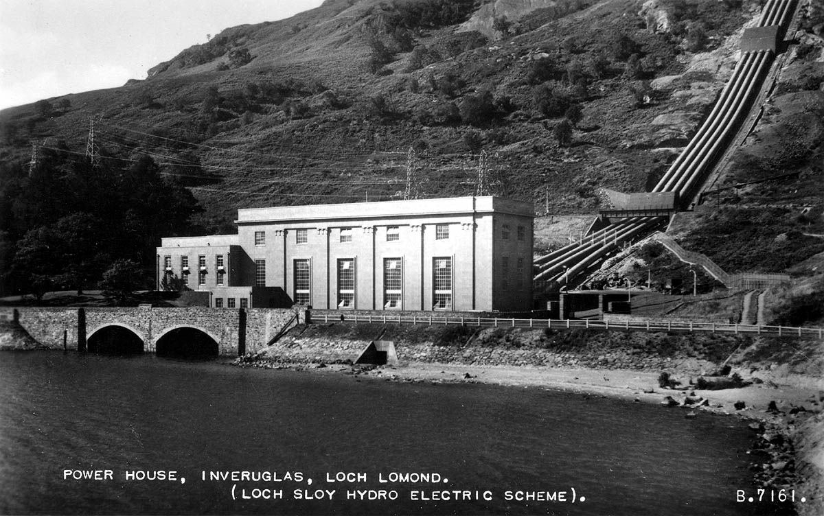
“Mouth of the dark stream” from “dubh”, dark and glais, water in Gaelic. The area or hamlet of Inveruglas, just 4 miles north of Tarbet, can hardly be missed. Indeed after Ben Lomond itself, Inveruglas houses the Loch's most easily identified feature - Loch Sloy Power Station and Hydro Electric scheme. The power station sits beside the A82 and the water outlet from the pipes, which drive its turbines, flows under the A82 into Inveruglas Bay.
 Loch Sloy itself lies high behind the hills from which the four water pipes run down to the Power station. However, for centuries before the building of the Hydro scheme, Inveruglas had a significant history. It lay at the centre of McFarlane clan lands from the 1220's - indeed the McFarlane clan war cry was “Loch Sloy”.
Both William Wallace and Robert the Bruce sought refuge in the wild lands at the northern end of Loch Lomond in times of trouble and the name given to the islet at the mouth of Inveruglas Water - Wallace's Isle - has been testimony for centuries to the belief that he hid out on the Isle for a time. The friendship which the McFarlane's made with Robert the Bruce extended to the whole Stuart dynasty, who sat on the Scottish and then United Kingdom throne right down to James II, from they broke in 1685.
For much of this time the clan chief's castle was on Inveruglas Isle in Inveruglas Bay, but in 1577 they had also built another one on the most northerly of the Loch's Islands Ellan Vhow. This was just as well, because their loyalty to the Stuart cause during the Civil War brought a visit from Cromwell's troops who not only attacked, but also burned the castle on Inveruglas Isle.
The McFarlane chiefs then took up residence at Ellan Vhow for about 50 years, moving to Arrochar in 1697. They also learned a lesson about choosing the winning side, and when in 1688 James II fell out with the country at large, the McFarlane's sided with Parliament, taking no part in any subsequent Jacobite rebellions in 1715 or 45. They played their hand quite skilfully at this time, because they also kept on good terms with their old allies and neighbours the McGregors, who were staunch Jacobites. Even in the McGregor's Loch Lomond Raid and the retaliatory Expedition of 1715, the McFarlanes were completely passed by, and no doubt happy to be just spectators at such a diverting spectacle.
Peace and transition came to even the northern Lochside as the 18th century wore on, with a military road being built from Tarbet to Glen Falloch and beyond in 1752 - 60. Unfortunately, large parts of that road are still the backbone of the A82, particularly just south and north of Inveruglas.
The whole shambles of a road is perhaps best exemplified by the infamous traffic light, about a mile north on Inveruglas, installed as an emergency short term measure about 30 years ago, to control traffic at a corner where the verge had fallen into the Loch. At least the West Highland Railway remains intact, and
Inveruglas played an important part in its construction. In a move that foretold the huge building site it was to host only 50 years later, Inveruglas was used as a base during the construction of the railway, the last of the great Victorian railway line constructions. Inveruglas's attraction to its builders was that materials could be carried by rail to Balloch and loaded onto boats and barges for shipment to Inveruglas, where the line is no more than a few hundred yards from the Loch.
The main base for the Arrochar - Crianlarich section of the line was at Arrochar, but the Inveruglas base was almost as important. Fifty years later, Inveruglas was the focal point of the whole of the Loch Sloy Hydro Electric construction project. From 1945 until 1950, Inveruglas was basically a huge building site - perhaps the largest in Scotland at the time, certainly by far the most challenging and complex.
There was a lot riding on the project. The North of Scotland Hydro-Electric Board had been formed in 1943 to “design, construct and manage hydro-electricity projects in the Highlands and Islands of Scotland”. This was tremendous act of faith on the part of a small group of individuals, backed by the government, at the height of a war, the end of which was not yet in sight. The first scheme the new board chose to build was the one at Loch Sloy.
It's hard to overstate the bravery of that decision, particularly since with 60 years of hindsight, it's very easy to take it for granted. The choice of Loch Sloy at that time was influenced by some very intelligent economic and political considerations as well as purely technical terms. The Board was committed to supplying electricity to the Highlands and Islands, a sparsely populated area where delivering electricity was going to be a loss-making exercise. So why not start off by supplying Glasgow and Clydeside and generate immediate profits, which could subsidise the rest of the Board's activities?
The wisdom of that thinking has stood the test of time, since almost all of the Sloy's production still goes to Windyhills substation, about 36 miles away on the outskirts of Glasgow, carried there on 416, 85 feet high pylons. The main technical attraction was the rainfall - measured at about 126 inches annually, in the Loch Sloy catchment area, which guaranteed a ready supply of water.
This, however, was only an attraction when the scheme was up and generating electricity. During the construction, the weather - rain, sleet and wind at the 800 feet at which much of the work was done - was actually a huge negative, making work very difficult for much of the time. The extent of the failure to anticipate the weather problem is perhaps best illustrated by the fact that at the outset in April 1945, the Board confidently forecast a completion date of 1947. As things turned out, although the then Queen officially opened Loch Sloy in 1950, the actual final completion date was 1951, an overrun of four years, but actually a great achievement in the hard light of reality.
Just a few examples of the adverse weather will suffice. Firstly, during the building of the dam 800 feet high in the hills, whose substantial concrete content made dry weather very desirable, it is recorded that there were only 21 days without rain during the three years it took to complete the dam. Secondly, in the principle construction years of 1948 and 1949, actual rainfall turned out to be 168 and 156 inches respectively, against an anticipated 126, while in one month alone over 26 inches fell - more than the annual rainfall for Edinburgh. Thirdly, even at Loch level the wind could be vicious - in Inveruglas Bay just where the outflow now reaches the Loch, a barge fully laden with sand from Paddy Caulfield's sand pit at Drumkinnon, was flipped over by the wind and sank (its still there) - and this in what looks to be a wind-proof bay.
On the bright side, the predictions about on-going rainfall have been handsomely justified, because at Loch Sloy dam on 17th January 1974, Scotland's wettest day ever recorded was measured at 9.9 inches of rainfall in 24 hours. Another consideration, before building got under way, was that being so close to Clydeside, the building project would provide plenty of jobs for an area, which had been badly hit by the depression. But the project started while most men were either still in the army or were in great demand in the yards and factories of west central Scotland, and there was actually a severe shortage of workers to begin with.
The answer for the first couple of years was to use German prisoners of war (POWS), many of whom were housed in camps around Faslane, erected for Allied troops heading for the invasion of Europe in 1944. As people came from all over the UK to work on the site, and the POWs started to go home, the mix of workers changed. But from late 1945 onwards, great use was also made of a group of eastern Europeans, who have been almost completely written out of the history of Scotland at that time. These were Displaced Person or DPs as they were referred to. These were people from countries which in 1945 were occupied by the Soviet Union Army, or else they were actually citizens of the Soviet Union (particularly from Latvia, Estonia, Lithuania and the Ukraine) who had either been taken prisoner by the Germans, volunteered to fight and work for the Germans or transported to Germany as slave labourers.
They had no wish to return home, most probably fearing they would be shot or sent to gulags. In a good many cases they would have deserved punishment because many had committed wartime atrocities against Jews and other civilians. However, Britain had too many of them to sort the wheat from the chaff at the time, and instead put them to work under very strict conditions. At Loch Sloy, they were paid 50% of the going rate, they had to take whatever job they were told to do, and they stayed in camps at Inveruglas, which were considerably more relaxed in security and life-style than the typical DP camp elsewhere in Britain.
The carrot was that they could work their way to some form of British citizenship if they performed their allotted tasks well. At the peak of the workload at the Sloy, it is reckoned that two thirds of the work force - which peaked at 2,200 - was DPs, and it is also reckoned that they were by far the most effective workers on the site. That's not surprising since their incentive was certainly unique and considerably greater than anyone else's.
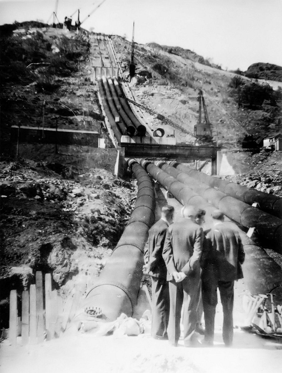
The build also suffered from equipment and material shortages - after all there was bomb-damage reconstruction going on all over Britain at the time. And finally, there was the sheer scale of the project. What is now visible from the Loch side is insignificant in the overall scheme of things. In the first phase alone, 15 miles of access roads had to be built into the hills, a diesel power station to power the construction sites was built (it also provided domestic electricity to the Loch side, Tarbet and Arrochar for the first time), a camp for the workers (there were eventually four such camps), two temporary railway stations and sidings, (one at Inveruglas itself), jetties into the Loch to handle the tugs and barges from Balloch, a new bridge carrying the A82 over the outflow, all had to be built before the serious business started, and most of this was completed by late 1945.
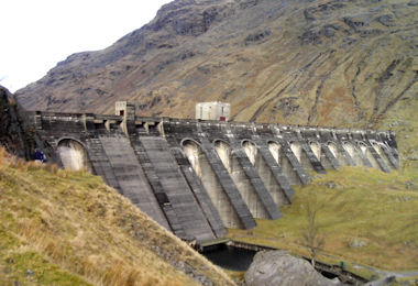
The Dam on Loch Sloy
But well hidden behind the hills from Lochside view are the dam, which raised the level of the Loch by 115 feet, the aqueducts and tunnels which divert hill burns into the Loch, and the huge tunnels and pipelines which carry the water from the dam through the hill and into the visible pipeline to the power station. Up close to the dam was a quarry from which most of the rock used in the construction was extracted, a concrete mixing plant, and an overhead cableway system which carried buckets of concrete to the dam face.
The tunnelling itself was a huge task, through two sets of mountains. The largest of the tunnels were those from the dam face to the top of the visible pipeline. The actual length of the pipeline is shorter than it seems from the Lochside, being just over 500 yards down the hillside to the Generating Hall, but it does come down at a pretty steep gradient. An inclined funicular railway was built to enable the laying of the pipes - each section of pipe is 24 feet long and weighs 15 tons, so laying it on that incline was itself no mean challenge.
The railway has been retained for pipeline maintenance. Apart from the rock quarry in the hills, everything had to be brought in. Some was brought by rail, some, such as 117,000 tons of the 147,000 tons of sand used, was brought in by barge, towed up from Balloch by a couple of tugs brought from the Thames to the Loch especially for that purpose.
Some, especially construction equipment and machinery for the power station, was brought in by road. Many of the bridges and culverts between Glasgow and Inveruglas had to be specially strengthened to take the weights involved. The New Bridge at Balloch was the only bridge over the Leven that could carry the heavy loads, so these loads had to take the Back Road from Dumbarton via Bonhill and Jamestown and then Lomond Road to the A82 at the Loch Lomond Hotel, Balloch.
The whole project came at a considerable human cost. In addition to many injuries, twenty-one men of various nationalities were killed during the construction. It seemed for many years that these deaths had been airbrushed out of the history of Loch Sloy, but now there is a memorial plaque listing all of their names in the Power Station building beside the A82.
Although a great challenge to build, Loch Sloy has proved a great success, both for the Board and its successors. A £113 million refurbishment of the Power Station was completed in 1999, which will give the power station another 30 / 40 years of service.
While it is not a scenic attraction, the Scheme has provided some benefits for the many hikers, climbers and walkers, who visit Inveruglas, either to climb its two Munros - Ben Vorlich and Ben Vane - or walk in the hills around Loch Sloy. The Hydro roads, although steep to begin with, make access into the hills very easy and provide convenient routes at Loch Sloy. The relatively new car park and public jetty at Inveruglas also provide a calling point for Loch users and parking place for the walkers, as well as a very convenient terminus for the Inversnaid Ferry.
Click on the images to enlarge in a new window
ARDLUI
The name of this hamlet at the north end of Loch Lomond - about 8 miles north of Tarbet, but it always seems much longer by road - means in Gaelic “the height of the calves”. This could have something to do with the practice of moving cattle to graze on higher ground in the summer months, when the farmers moved into hillside sheilings. There are a number of ruined sheilings in the hills around Ardlui and nearby in Glen Falloch, which would support this possible explanation.
Ardlui itself actually lies on the west bank of the Loch, separated from the east shore partly by the last few yards of the Loch, but mainly by the River Falloch. The Falloch shows clear evidence at Ardlui of the work done in the 1840's to make it a canal. The local landowner, the Marquis of Breadalbane, did this so that the steamer, which he had started to operate on the Loch, could bye-pass Ardlui and sail straight to Inverarnan Inn. There he had built a landing stage for the steamer, and he had also established a stagecoach line to run from there to Fort William and Killin.
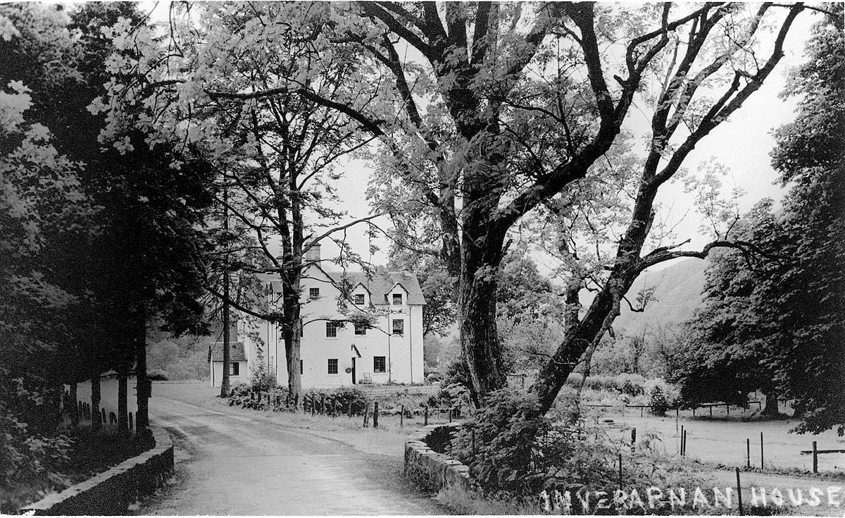 Inverarnan Inn at that time was already well used by drovers and other travellers, having been opened in 1705, and after the road through Glen Falloch had been greatly improved in 1840, it made good business sense to introduce stage coach services to it, with onward steamer connections to Balloch and beyond.
The Inverarnan steamer connection offered a walk-on service at a time when there were no piers at any of the Lochside villages, and passengers were ferried from steamer in small rowing boats. When Ardlui got its own pier about 1847, steamers called at that pier as well. Since the existing Loch Steamer Company provided the Ardlui sailings, and had the connections at Balloch pretty well sewn up, Ardlui attracted more customers.
In 1873, when the railway line from Stirling to Oban reached Tyndrum, the coaches moved from Inverarnan to Ardlui, heading for the railway at Tyndrum. After this Ardlui became the recognised northern steamer terminal.
An attempt was made in 1881 by Colquhoun of Luss to build a suspension bridge over the Falloch at Ardlui, but Breadalbane, who claimed rights of navigation on the Falloch, thwarted this in court and the Falloch remains unbridged there to this day. The bases of the two intended bridge towers are still quite visible on each bank of the Falloch.
The West Highland Railway arrived at Ardlui in 1894, and the station was no more than a few yards from the pier, providing tourists from Glasgow with an easy train - steamer - train day out. This was not quite the end of stagecoach services out of Ardlui, since they still seem to have run from the pier to Crianlarich until 1912, perhaps to provide a link to the Oban railway line at Crianlarich for steamer passengers.
Ardlui Pier closed to the Maid of the Loch in 1964. It was soon reduced in size to meet the needs of the marina, and boatmen calling at Ardlui Hotel, and since Ardlui did not participate in the pier refurbishment program of 1978-83, the 1964 closure signalled the end of Ardlui as a steamer port of call.
The caravan park beside the hotel was also opened in the 1960's and has proved very popular. In the last 30 years or so Ardlui has attracted substantial numbers of tourists, both on land and by boat, and this in turn attracted investment in new hospitality facilities. At one stage in the 1990's, each permanent resident at the north end of the Loch could practically have had a bar to themselves.
The oldest establishment was the Inverarnan Inn, by now renamed the Drovers Inn, which had risen like Lazarus, from what seemed like certain closure in the late 1950's and early 1960's. At that time, it probably catered for the occasional angler and walker, but since so few people went in, there are few surviving witnesses. However, its potential was spotted and within a few years it had carved out a reputation as an authentic old style droving inn.
It became and remains a highly popular destination with walkers, drivers and boaters, particularly anglers, who sail up the Falloch taking advantage of the long-disused canal. In the early 1990's a potential rival to the Drovers was opened straight across the A82, called the Stagger Inn. Suffice to say that it is now an annexe to the Drovers.
Ardlui Hotel is a classic Victorian Scottish country hotel. It too has carved out a popular niche for itself, and it too attracted competition in its immediate vicinity in the early 1990's - in this case about 200 hundreds yards north on the A82. It was originally called the Bunk House and was aimed primarily at walkers on the West Highland Way. It is an attractive modern building and had some initial success, after which it was closed for some time. It has changed hands a couple of times and now operates under the name McGregors Landing.
Click on the images to enlarge in a new window
![]()