Place Names (H) Halkett Crescent - The Huts
Halkett Crescent, Alexandria
This street in Rosshead Estate dates from the early 1960's when Rosshead was built, and is named after George Halkett, a Communist County Councillor from the 1930's and 40's, when the Vale had the name Red Vale. It forms one half of the road which circles Rosshead, the other being named after Sir Iain Colquhoun, about as un-Communist as its possible to get, who was a contemporary of George Halkett on the Council.
Hall Street, Bonhill
This very short Street connects the south end of Union Street with Burns Street. It is named after the former Volunteers / Territorial Army hall, which still stands on Burn Street, just opposite Hall Street's eastern end. It was built about the 1890's.
Hall Street, Renton
Named after the Public Hall in Renton, which was opened in 1882 and was located at the corner of the street. Hall Street was part of the extension south and westwards in Renton of the 1880 period. The older houses on it were demolished and replaced by the ones currently on it in the late 1960's.
Hannah Place, Renton
This short street leads off the east side of Cordale Avenue, in the new Cordale Estate. It was built in the 1990's and is called after Andrew Hannah, the captain of the Renton FC World Championship side of 1888, and a Scottish Internationalist. Not only was Hannah a skilful footballer, he was a highly accomplished athlete, particularly in the hop, step and leap as it was called then, where his performances were amongst the best in the UK at the time. In the 1890's he could pole vault 9ft, which would still have been respectable at a Scottish championship level 50 years later.
He went on to captain both Everton and Liverpool, and in Liverpool accepted a challenge to enter a cage full of lions. The lions obviously recognised one of their own, and his reception by them was friendly, but after he'd captained Renton, lions were, figuratively as well as literally, just pussycats. Like Alex Jackson later, you're left wondering why a person of such considerable achievement and interest has passed unrecognised for so long.
Haran Road, Balloch
Named after Michael Haran, a Labour county Councillor in the 1960's and 70's who was the first Regional Councillor to represent the Vale on the old Strathclyde Regional Council when it was established in 1974.
Hardie Street, Alexandria
This Street, which runs north - south through Levenvale, was one of the original 1935-6 roads, and is a mixture of timber and brick houses. Like all of the other original streets in Levenvale (except Lomond Road) it was named after a left-wing personality - in this case Keir Hardie. Hardie, who was born near Holytown in Lanarkshire, is regarded as the founder of the Labour Party and was one of the first MP's elected to represent the Labour. He died in 1915.
Hazel Walk, Dalmonach Estate, Bonhill.
This was a pedestrian-only Walk at the southern end of the post-war Dalmonach housing estate, which consisted of about two dozen aluminiums. It ran from First and Second Avenues, but when the aluminiums were replaced by brick-built houses, the Walk disappeared. The “Hazel” is to lend a rustic tone and refers to the hazel tree rather than any person.
Heather Avenue, Alexandria
This Avenue, which runs from Main Street to the River Leven towpath at the entrance to the old Pan Lade in Alexandria, is one of the oldest thoroughfares in the Vale. Its initial use was probably to gain access to the Dalvait ford over the River Leven from the Lochside - Dumbarton road. This was the ford used by the ill-fated Covenanter, Earl of Argyll, in 1685 as he led his small army en route from Inverary to Glasgow and he probably came down the Heather Avenue.
The importance of the access to the ford shouldn't be underestimated, because there was not a bridge over the Leven until 1765, and that one was at Dumbarton. Also, long before that, Dumbarton tried to levy a toll on everyone passing the town on their way to and from the market at Glasgow. Both of these factors made crossing at Dalvait a popular option.It was also a popular crossing point in later years with drovers taking cattle to market, particularly after 1770 when Falkirk Tryst displaced Crieff as the most important cattle fair. The move to Falkirk made west Loch Lomondside and Balloch a preferred route for drovers from mid and south Argyllshire, and Islay and Jura.
By the early 1800's, the Heather Avenue was also providing access to Levenfield Printfield and what was to become Croftingea and Alexandria works. Many of the managers' houses were located on or just off, the Heather Avenue. Because it was a well surfaced, long straight, it became popular as a training ground with the local “peds”, as the professional runners were called. When the Balloch - Stirling railway line was built, the railway bridge that was built over the Avenue substantially reduced height clearance. Also, the surface under the Bridge flooded easily and it was usually very muddy.
The bridge was removed in the mid 1960's after the line closed, and Rosshead Estate had been completed, giving once more unrestricted access to the towpath the whole way down Heather Avenue. These days, the Avenue is the busy vehicular access road to Rosshead Estate, Antartex and Loch Lomond Distillery and the new housing development on the old Torpedo Factory site, as well as to the Angling and Rowing Clubs on the towpath.
Heigh Field, Jamestown
This is the nickname given to Levenbank Works. It means high field (Printfield) and it distinguishes Levenbank from Milton Works - Laigh Field (the low field) that was lower down the Leven.
High Dykes, Bonhill
This area of Braehead, Bonhill, in which a primary school of the same name is located, is named after an old farm called High Dykes Farm. It was approached from High Dykes Loan an ancient track that led from the Bonhill - Dumbarton road near the boundary of the two parishes, not only up to the hill farm and the moor, but also into the Murroch Glen. The Loan was more or less above Strathleven House.
The High Level, Bonhill
The High Level is an old name for the area due north of the top of the Burn / Burn Street in Bonhill. It is also still in current use by old, and not so old, Bonhill hands. Originally, it was probably applied to what became better known as the Slunger, in a general line of what is now Hillbank Street and then Northfield Road. However, it came to refer to an area as well as a road and these days is loosely applied to the Hillbank Housing Estate, the top of Dalmonach Road, and Northfield Road, although anything that is on the hillside north of the Burn seems to qualify as well, from the Burn to Auchincarroch Road.
Hill Street, Alexandria
Hill Street was one of three streets (Park and Fountain were the other two) built in the 1860's and 70's as Alexandria expanded westwards, to connect Main Street firstly with the new Middleton Street and then on to the new Smollett Street. Little imagination was shown, it was just the road to-wards the hill on the west side of the Vale. It could also have referred to the Ritchie Hill. The police station moved from John Street to Hill Street in the mid 1930's.
Hillbank Street, Bonhill
To begin with (before about 1800) Hillbank was known as Hillton, and at that time and thereafter, the road past Hillton / Hillbank was known locally as the “High Road”, while the military road which became Main Street was known as the “Low Road”. It was therefore something like an early version of a Bonhill bypass. Hillbank seems to have come into use in the early 1880's.
A distillery, which unfortunately burned down in 1827, and was not replaced, stood either on Hillbank Street or very close to it, where an old track went up to what was then Northfield Farm. A short stretch of Hillbank Street also served as part of the drove road to Falkirk Tryst before it made its way up the hill. Until the development of the Dalmonach scheme in the late 1940's, Hillbank Street's northern end led onto one of the most famous tracks or roads in the Vale, the Slunger.
Hillfoot, Renton
This northern extension of Back Street runs from Red Row to Cardross Road. It was built by the council in the 1920's and 30's and, with Burnbrae, contains some very fine red sandstone houses. The name originates in the 1920's and is self-explanatory being at the foot of Carman Hill.
Horseshoe, the
This is a much-loved Vale walk, cycle, or run, not just of days gone by but very much of the present, which takes the broad shape of a horseshoe. Going in a clock-wise direction, it leaves the Balloch - Stirling road at Ballagan, at what used to be Ballagan Garage but is now Reid & Robertson's agricultural stores, where it climbs Westerton Hill. It then passes Lochend and continues for about 3 miles in an easterly direction past the Gartocharn road end before turning sharply right or south to drop into the valley of Gallangad Burn.
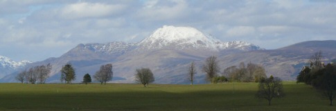
A snow covered Ben Lomond taken from the Horseshoe
Passing over the old Balloch-Stirling railway line at Gartocharn or Caldarvan Station it then climbs to a crossroads at Merkins Farm road end. Turning right or westward, this is the eastern end of Auchincarroch Road. The road twists and turns up hill and down dale for about 3 miles, past the land-fill site which is changing the Vale's eastern ridge line, the end of both the Tinkers Loan and the Rickett Moss walks and down into Jamestown between the edge of Dalmonach estate to the south and Gilmour & Aitken's timber yard to the north, ending at the T junction at Milton Estate where it meets Main Street Jamestown. There you turn right, or north, to return to the starting point. Ballagan to Ballagan is 7.8 miles, while Ballagan to the Auchincarroch Road end is 6.2 miles.
Hostels the, or the Hostel Houses, Balloch and Jamestown
These were a collection of single-story buildings erected at the outbreak of the 2nd World War, on the site of the old Jamestown Golf Course. Dalvait Road bounded them for their entire western boundary, Lomond Road on the north, Carrochan Road on the east and southeast. The hostels were located on both sides of the Carrochan Burn, with no adjoining bridge to get from one part to the other. You had to use either of the existing Carrochan or Dalvait bridges. They were therefore partly in Balloch and partly in Jamestown.
They took their name from their initial function - to house people who came into the area to work in the war effort. In that respect, and superficially in their appearances they resembled the Huts. At the end of the war, their functions were divided - the Jamestown “hostels” were used to house local people from the council housing waiting lists and continued in that role until the new houses in the Haldane became available from about 1954 onwards. They continued in variations of council housing roles until they were demolished in the 1960's to be replaced by the Carrochan Estate and St Kessogs Primary school.
The Balloch hostels, on the other hand, were initially (1946 - 48) used to house eastern Europeans who did not wish to return to their home countries - which were either Russian or countries controlled by Russia after the war. All were some form of refugee and were termed “Displaced Persons” (“DP's” in the parlance of the time). By the time they got as far as the Balloch hostels, Britain had satisfied itself that they weren't likely to be war criminals, and they had gained some form of British citizenship or residency status. Within a few years, they had dispersed throughout the UK, although some did stay in the area.
The Balloch hostels then became a naval store, each of the houses containing bedding. The superintendent stayed in a cottage close to the gate on Lomond Road. The couple of dozen buildings were guarded round the clock by civilian guards, headed up by big John Urquhart, who had retired from his role as Balloch's legendary policeman from the 1930's to the early 1960's. Eventually in the late 1960's they were demolished and in the early 1970's the Dalvait Housing estate was built on the site.
Hudspeth Court, Alexandria
This short road in Tullichewan, built in the 1960's, is named after Miss Hudspeth who was for many years the Matron of the Vale's cottage hospital, the Henry Brock Hospital or Bromley, as it was better known. It was of course replaced by the Vale Hospital, which opened in 1957. In this stage of building Tullichewan, many doctors are recognised, but this is the only nurse.
Huts, The, Levenvale
Or to give them their proper name, Admiralty Cottages, Alexandria. These were built about 1915 to house munitions workers who came to the Vale to work in both the Argyll Motor Works, which was converted to produce munitions from 1914 until 1919, and also the adjacent Lyddite works which produced explosives.
Belgian refugees, who had fled the Germans, and worked mainly in the Lyddite, were also housed there. They were sited in what became Levenvale in an area broadly bordered by Argyll Street to the south, Burns Street to the east (where a solitary “Hut” survived until the 1970's), about Hardie Street to the west and about halfway along the present Lansbury Street to the North. T
he Huts were single-story buildings intended as a temporary quick fix and very much like the post-Second World War aluminiums, never meant to be permanent. They were laid out in a grid system with an East and West square at each boundary and parallel north-south streets, numbered 1st to 8th Street, connecting the north and south rows of houses. After the war, when all of the refugees and most of the munitions workers left, local people moved into the Huts. Again like the aluminium's of the 1940's, they proved very popular with their tenants. They were only demolished in the 1930's to make way for the building of the new Levenvale estate.
![]()