Place Names (L) Lade to Lynn Walk
Lade, The, Sandbank
This small housing estate, built in the late 1980's on the banks of the Leven at Sandbank, is named after the Dalmonach Lade, the entrance to which was adjacent to this estate.
Lady's Gate, Bonhill
There have been two places with this name, and both are related to Strathleven Estate. The first Lady's Gate goes back a few centuries and risks being lost in the mists of time. It dates from when Strathleven was still called Levenside and relates to a gate from the Estate onto the Dumbarton - Stirling road. However, we don't know exactly where it was or after whom it was named. A complication is that the line of the road was altered from running right in front of Strathleven House, to its present alignment. But no matter, the Gate did exist.
When the developer of the private houses at what became Strathleven Park came along in the 1970's, he hit on what is really a very bright but simple inspiration - call one of the early streets Lady's Gate, and virtually all of the rest lady's names. Three birds killed with the one stone - a strong local connection, a very much simplified selection of street names - Sheena, Lorna etc to which no one could take any exception, and a number of happy wives, partners, employees etc. Many a developer / planner since, must have looked on in envy.
Ladyton Estate, Bonhill
This was the first of the hillside estates to be built in Bonhill in the 1960's and 70's, and most of the layouts, numbering, etc, were tried out here before being applied in the other later estates. To begin with, the main planner / designer of the whole hillside development took up residence in the old Ladyton Farmhouse, with the express objective of showing that he was prepared to live in what he designed.
This was a bold step, and you have to think that a few things would have turned out differently had he lived - such as the numbering system - but sadly he died in the early days of the building program. Almost from the start there was a small shopping complex, as well as the first pub on the hill, and then Ladyton Primary School. It's hard to believe that it is now over 40 years old.
Ladyton Farm, Bonhill
The present Ladyton housing estate stands on the site of an ancient farm, Ladyton Farm. It derived its name from the fact that during medieval times “Upper Bonhill” was given to the chaplain at the church of the Virgin at Dumbarton, and became the “town and lands of Our Lady”, hence the name.
General Wade of road building fame is supposed to bivouacked at Ladyton when he was engaged in the building of the Dumbarton - Stirling military road, and his men are said to have used Ladyton Spring, improving it in the process. Wade departed Scotland years before the start of building this road (1755), so that part of the story is untrue. But its quite possible, even likely, that the soldiers used and improved the Spring.
Ladyton's best-known farmer was James Shanks, who farmed there in the latter half of the 19th century. Not only was Shanks prominent in local affairs, particularly the Freeing of the Bridges movement, but he also wrote the words and music to one (of two) of the best known and most sung, songs about the Vale, Beautiful Vale. One of the tracks up to his farm was known as Shanks's Loan, but it is long gone under Ladyton Estate.
Ladyton Springs, Bonhill
Ladyton Springs was not only a well, it was also one of ways by which you knew a true Vale person, because the Vale's most unique product was made from water drawn from the Springs - McDougall's Lemonade. The Spring was within the McDougall's Ladyton Springs Lemonade Factory from the day it opened in the 1880's until it closed in the 1990's. Anyone who preferred any lemonade other than McDougall's could lay no claim to being a true Valeman or woman.
The factory was situated in Croft Street Bonhill. Alex McDougall sold the business in the face of increasing food regulation (as a result of various scares caused by multinationals) and competition from the large supermarkets. It has been much missed. The Levencroft Mews houses now stand on the site of the former Lemonade Factory.
Laigh Field, Jamestown
This was the nickname given to Milton Works Jamestown. It means the Low Field (bleaching or printing works) because it was lower down the Leven than the “Heigh Field”, High Field, which was Levenbank Works, and which was higher up the Leven.
Lamont Crescent, Renton
This short Crescent just off Cardross Road at the foot of the brae is called after Bill Lamont - better known as “Bunger” Lamont. Bunger, born in 1900, was a Communist County Councillor for Renton West from 1958 until his death in 1974. Held in high esteem and affection by all, Bunger was a great Renton character and man “o' a' the airts”. He got his nickname from his days as a winger with one of the Renton football teams, with his constant shout to his teammates to bung the ball to him.
Lansbury Street, Alexandria
This, the main street through Levenvale, was built in the mid 1930's. Like many other streets in Levenvale it is called after a left-winger, in this case, George Lansbury, who was the then leader of the Labour Party (and the uncle of the actress Angela Lansbury). It must hold the record in the Vale for having the most householders in continuous occupation since the houses were built 70 years ago - now of course they are the sons or daughters of the original tenants.
Laudervale Gardens, Balloch
This private development, lying between Balloch and Lomond Roads at their western ends, is a mixture of conversion and new build of the Loch Lomond Hotel and its grounds. The Mason family, who moved to the Vale from Glasgow, had built the Hotel in the 1930's. The son, Billy, was an accomplished pianist who for a time led a band at the Loch Lomond in the American style of the 1920's and 30's. He emigrated to the US, and had a successful career there, mainly in New York, playing piano in bands led by the leading musicians of the day - including Louis Armstrong, who came down to visit the Hotel during one of his tours in the 1950's.
In the early 1950's, the Masons sold the Hotel to Mrs (“Ma”) Barton, previously of the Rob Roy Motel at Aberfoyle, and the Hotel entered its golden period in Vale reminiscence. Although, at best, she was a difficult woman, as she herself would admit at least 6 times an evening, she ran an excellent hotel and hostelry. It was the first choice for weddings and dances, and the Alexandria Burns Club had it Annual Burns Festival in the Hotel for about 20 years.
Mrs Barton's sale of the Hotel in the early 1970's was followed by a fairly rapid decline in its business. In the early 1980's it was sold for redevelopment. The hotel and out buildings were converted to flats, while a new west-facing three-storey block of flats was built on the south side of the hotel. The Lauder part of the name is presumably a reference to Sir Harry Lauder.
Ledrish
Ledrish appears in three place names in the Balloch area. There are two farms with Ledrish in their names – Ledrishmore and Ledrishbeg – and there is Ledrish Avenue, in Mollanbowie Estate, Balloch which obviously takes its name from the farms. The farms are ancient, having been mentioned in the Partition of the Lennox of 1493 as “Ladryshbeg” and “Ladrishmor”, when they passed into the hands of the Haldane of Gleneagles family after whom Mill of Haldane is named.
They appear again from time to time in history as the property of the Ewing family, which is described by some historians as “an old Balloch family”. Both farms were owned in the late 18th and early 19th centuries by the grandfather of the Orr Ewings and Ewing Gilmour who were prominent owners of textile finishing factories in the Vale for much of the 19th century, although they are now long gone. Ledrish could derive from the Scots Gaelic leathad, meaning a slope or a hill, which is still an apt description of both farms, although lenrick, which has a Cumbrian origin, a clearing or glade, might also be a possibility.
Lennox Street, Alexandria
This short Street in the middle of the old Vale runs between Alexander or Craft Street and Wilson Street. It dates from about 1820 when Craft Street and North Street were being built on, and was expanded to Wilson Street when it was built in the 1850's. It marked the eastern boundary of the gas works, which started further up North Street in 1835.
From about 1873 until 1888, the North Street Park of the old Vale FC also stood in Lennox Street. Now, it largely consists of derelict former industrial sites, such as the old Lennox Foundry, but moves are apparently afoot to clean it up and build houses on large parts of the area.
Lennox Street, Renton
Lennox Street Renton is the southern extension of Renton's Main Street, part of the south Renton expansion of the 1880's. The decision to change the name of what is the same street was probably made by the builders to emphasis the newness of the whole project.
Lennox Street starts at Hall Street / Leven Street and runs the very short distance to just beyond John Street, where it changes its name again, this time to Renton Road, or more likely, The Renton Road. “Woodvale” the fine red sandstone terrace building on the east side of Lennox Street is the southernmost building of Renton's 19th Century past.
Lennoxbank House, Balloch
This handsome house stood between Dalvait Road, Balloch, and the Leven. It was built in 1825 for John Stuart, who was a partner in the nearby Levenbank Works. At the time, Dalvait Road ran right through the site of the house and its gardens, and the Road was therefore re-aligned onto its current course.
The house passed through a number of hands, including the Orr Ewings who owned many of the local textile works, and local quarryman and road haulier Paddy Caulfield. Caulfield sold it to Glasgow lawyer and businessman, Harry McGhee, about 1960. The House was then turned into the Lennoxbank House Hotel, with all of 5 bedrooms - the minimum requirement for a 7-day hotel licence. Early residents included Cliff Richards in one of his appearances in Glasgow.
For a number of years the Hotel prospered, not least because it was well run and popular with locals. This was especially true of the Friendly Bear Lounge, which struck a chord on any number of levels with Vale folk. Many's a homeward bound customer who had a very sensible conversation with the large stuffed bear, which was a prominent feature of the Lounge. It also had a function suite, which hosted many weddings, dances and Burns Suppers.
Jetties were built parallel to the river and a cruising enterprise - Lomond Marine Cruises - was launched, using specially built waterbuses based on the Amsterdam canal boat design. This part of the business was not a great success and it closed down after about 10 years of operation.
In the late 1960's, Lennoxbank built a new function suite on what had previously been Knowehead. This was the Waterlot and it quickly became a very successful venue, regularly featuring both national rock bands and more local and traditional bands. The band on its opening night was a long-forgotten group called the Edinburgh Crusaders, whose manager was a certain Tam Paton, before he discovered the Bay City Rollers. Equally at home were the Scottish Country dance bands that played at the Balloch Highland Games dances, which were held there for many years.
Lennoxbank changed hands and it went into an almost stereotypical decline. The business eventually closed and the old house was gutted by fire and lay derelict for many years. The Waterlot had an even more spectacular fate. After a heavy snowfall on the empty and cold building, the roof collapsed and when the snow melted it was clear from the warped roof and bulging walls that the building was finished. It wasn't immediately demolished however, and became something of a local feature.
Robin Campbell, a highly successful local businessman, who eventually sold it for housing, bought the whole site. On the site of the old Lennoxbank House there now stands an impressive block of modern flats, built in the 1990's, with a fine view out over the original gardens to the river, and retaining the name of Lennoxbank House.
Leven Street, Alexandria
Leven Street still exists, just, running southwards from the Bridge Street roundabout at the Baptist Church to the Leven at the Vale Juniors car park at Millburn Park, and it is the River bank destination, which gave it its name. Only a few buildings actually stand on Leven Street these days - a garage and the old Labour Exchange, long since converted to flats, but still a listed building. This is because, having been built in 1936, it carries one of the very few crests of King Edward VIII, who abdicated in December 1936. However, it does provide access to Cloverleafpath and Thomas Street and beyond.
It used to be a busy enough road, right from its creation in the 1840's, when the building of Bridge Street got under way. At one time it gave western access not just to Thomas Street but also to what was then Alexandria's public park, Parkneuk. The park was gradually encroached on, partly by Leven Street buildings. The largest of these was that great Vale institution, Angus the Baker's. Their bakehouse, shop and offices opened in Leven Street about 1860, and stood there for nearly 100 years.
The Vale of Leven Laundry was located in Leven Street for many years and when it shut the building was taken over by the Vale District Council cleansing department. The Vale Emmet's football park was on the land now occupied by Cloverleafpath.
Leven Street, Renton
Leven Street runs eastward from Lennox Street to Alexander Street, parallel to John Street. All four were part of the southwards extension of Renton in the early 1880's at a time when the textile trade was booming. It contains fine red sandstone terrace buildings, typical of the type being built, using local stone, throughout the Vale at the time.
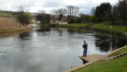
Leven, The River
The name Leven is generally agreed to derive from “leambain”, the Gaelic for elm tree. The river flows from Loch Lomond at its southern end at Balloch in a southerly and southeastern direction to flow into the River Clyde at Dumbarton Rock. In a straight line, this distance is just over 5 miles, but because of a number of bends the course of the Leven is about 7 and a half miles.
The Normal Tidal Limit (“NTL”) of the Leven is at Dalquhurn Point, so the last 2 and half miles or so are tidal. The surface of the Loch is about 30 feet above sea level, but it is the largest inland water mass in Great Britain. That, allied to the fact that the Leven has a mean depth of about 3 feet in the summer, and about 11 feet in the winter, result in it being a very fast flowing river - typically flowing at over 5 miles an hour - only the Spey flowing faster in Scotland.The main tributaries of the Leven are the Carrochan, Bonhill, Poachy (or Millburn) and Murroch Burns.
It was a major trade route into the southwest highlands from time immemorial. Boats of various sorts and rafts sailed not only on the Loch but also down the Leven towards the Clyde and the open sea. Vikings used it in 1263 after their raid on the Lochside, immediately prior to their defeat at the Battle of Largs.
Timber from Luss was floated down the river for the building of the roof of Glasgow Cathedral in the late 13th century, and about a century later more timber from the same source passed down to help build James IV's navy, by which he became the first king to control the western Highlands and Islands. In later times the boats carried stone, slate and agricultural produce out, and coal and fertiliser in. Only the arrival of the railway in 1850 saw the demise of that trade on the Leven.
From 1715 onwards, the river's plentiful supply of fresh clean water brought the textile finishing industry to the banks of the Leven, and between then and 1980 no less than 12 works were operated on the river banks over the years (or in the case of the Silk Factory a few hundred yards from it). In spite of the pollution from these factories, the Leven was until the last 30 years or so one of Scotland's best fishing rivers.
It was so prolific that there were a number of points at which nets could legally be drawn across the river (they were rented out by the local landowners). These were known as “shots” and the most profitable were at Balloch in front of the Fisherwood. They operated right up until about 1882, when the forerunner of the Loch Lomond Angling Improvement Association negotiated Leven fishing leases with the Colquhoun Trustees, particularly the 20-year lease starting in January 1896.
As well as being an important boating route, the Leven was an important east-west crossing point and there were 5 main fords in the river, the busiest of which were at Balloch (Dalvait), Bonhill and Dumbarton, with another 2 at Cordale and Dalquhurn respectively. It was not until 1765 that there was a bridge across the Leven (at Dumbarton), and it was another 71 years before the second was built at Bonhill in 1836.
By the mid 19th century there were three road bridges across the river and those at Bonhill and Balloch were toll bridges, although they clearly should not have been. The controversy raged for half a century and more. In total there are 10 bridges over the Leven, including two former railway bridges.
A passenger steamer started sailing out of the Leven at Balloch and onto the Loch in 1818, while by the 1880's boating was a popular activity on the river at Balloch, and has remained so ever since.
In the late 1960's the building of a barrage started at Balloch as part of a scheme to extract water from the Loch at Ross Priory for consumers not only in central Scotland but also on the south side of the Clyde. The scheme and the barrage became operational in 1971. The barrage has remained very controversial since it was first announced. Some believe that it has caused major erosion on the Loch shore. What cannot be denied is its impact on the level of the Leven in the summer, when it is frequently down to a trickle underneath Bonhill Bridge.
In December 2006 when the Leven was at its highest level in living memory, the water was actually flowing around the Barrage, straight from its north ramp to its south ramp on the western bank of the Leven. The Leven has remained a legally navigable river for its whole length in spite of the barrage, and the hoary old plan to “canalise” it has once again raised its head (February 2008), as if there weren't better things to spend the money on in the Vale.
Levenbank Estate, Bonhill
This is the name, which the developer, Turnberry Homes, has just (2007) given to the new private housing estate currently being built on the old Dalmonach Works site. This continues a trend on the Jamestown / Bonhill border of calling new housing estates after former textile works - although not the works on which they are built - which will confuse future historians. No bad thing, of course.
Levenbank Gardens, Jamestown
This small private estate overlooking the Leven on the west side of Main Street, Jamestown, is almost hidden from view, like most of the buildings that preceded it. Built in the 1980 / 90's it stands on land previously occupied by the Levenbank Works Manager's house.
Levenbank Road, Jamestown
This road is a cu-de-sac which runs from Main Street Jamestown into Jamestown Industrial Estate. Its entrance is more or less where the entrance was to Jamestown Railway Station goods yard was and it runs parallel to and very close to the track of the former Balloch to Stirling railway line. The Industrial Estate stands mostly on the site of the former Goods Yard, although it does extend a bit further east. The Road dates from the early 1970’s when the Industrial Estate was opened. These days the Industrial Estate is home to a number of busy small business including PA Tyres, a car wash, Premier Upholstery, Argyll Body Repair Shop, Alexandria Self Storage, and GLT Garage. All of these businesses stand on Levenbank Road, which takes its name from the nearby former Levenbank Works and Terrace.
Levenbank Terrace, Jamestown
The most northern of the Jamestown Terraces, it started on the southern side of Jamestown Railway Station and worked south. Like all the other Jamestown Terraces, and the Dillichip ones, it was built by Sir Archibald Orr Ewing for his workers in his nearby works.
He started with Ewing Terrace in 1864, beside the Station, which became incorporated into Levenbank as it expanded southwards from 1867 onwards. This became known as the Piano Terrace, because every home in it was supposed to have a piano. There were in fact two terraces, separated by a gap for access, not only to the rear of the terraces, but also a field behind them - Munro's Park - in which a small-holding and dairy was based for many years.
The original terrace was called the Upper or Old terrace, while the more southerly one was the New, Long or Lower terrace. It had 72 houses, while the Old terrace had about 30. Both were two-storey red sandstone buildings, built with local stone. Jamestown Police Station, a one-man operation, was located in Levenbank Terrace, although it closed about 15 years before the terrace was demolished in 1974. This was about 10 years after the Milton and Napierston Terraces had been demolished.
The name has been given to the private housing estate which was built in the 1990’s on the original Levenbank Terrace site. The new houses are much closer to the Jamestown – Bonhill road, with some of them standing on what had been a strip of grass, trees and wide pathway in front of the Terrace and extend for the full length of the original Terrace.
Levenbank Works, Jamestown & Balloch
Watson, Arthur and Co opened Levenbank Works, known as the “Heigh Field” or High Field, in 1784. It changed hands in the early 1800's, and it also changed name to Lennoxbank Works, by which name it was known until bought in 1845 by Archibald Orr Ewing. It was the first factory he owned outright after he left Croftengea Works, which was owned by his brother. He named it Levenbank, and it was the foundation of his textile empire and his very considerable wealth.
He completely replaced the original small factory, rebuilding Levenbank from about 1850. The buildings, which survived until the 1980's, were his creation. It was expanded until it was bigger than the village of Jamestown and continued in decreasing production, right up until the outbreak of World War Two. Then, however, Levenbank became a victualling store for the Admiralty - among the other prized items stored there was Navy Rum for the sailors' daily tot.
It did not re-open as a textile factory after 1945. However, some of the buildings were let out to a variety of companies after the war. These included:
- Franco Signs, makers of neon advertising signs
- Wallcraft Paint, as the name suggests, made paints
- Leddy & Glen processed photographs.
These companies were there from the late 1940's into the 1950's. There was a cattle market in the middle of the works, accessed via the Dalvait Road gate. It was well used by local farmers for many years.
- Wellowear made babies clothes
- Loch Lomond Import Trading Company who dealt in wood, were there for a time in the 1950's.
- Jamestown Concrete made concrete slabs and paving stones until well into the 1980's.
- Kuntz Engineering had a light engineering works also until at least the late 1970's.
The building occupied by Kuntz was then converted to flats, which are on Riverside Court and entered from Dalvait Road. This is probably the last large Levenbank Works building still standing.
The rest of the buildings were demolished in the 1980's and early 1990's to be replaced by houses on Honeysuckle Lane and Bramblehedge Path, which are entered from the old Main Gate of Levenbank Works on Jamestown Main Street opposite Arthurston Terrace.
Levencroft Mews, Bonhill
These private houses were built in the early 1990's on the site of what had been McDougall's Lemonade factory at the corner of George Street and Croft Loan Bonhill.
Levenhowe Road, Balloch
This road runs from Dalvait Road down into what was the old area of Dalvait before it disappeared into Levenbank Works in the 1850's. The new private houses, built in the elate 1980's - early 1990's also stand on land occupied by James Barr's house until the 1930's - he provided a vivid picture of Balloch in the early part of the 19th century.
Levenvale, Alexandria
This housing estate in north Alexandria was built in the mid 1930's to alleviate housing overcrowding, particularly in the centre of Alexandria. The southern part of the estate was built on the site of the Admiralty Cottages, which were torn down to make way for the new houses. The northern part was built on green fields, up to the then new Lomond Road (1936), which was carried over the Leven by the New Bridge.
The estate was a mixture of brick-built and part-timber houses. These timber houses were at that time an innovation for the council. While they were being built, someone painted the name “Timbertown” in huge letters on the pile of wood awaiting use, and for many years the affectionate nickname Timbertown was applied to Levenvale.
In the late
1940's / early 1950's additional housing in Lomond Road and
Lomond Crescent completed the Levenvale estate as we know it to-day.
The name Levenvale is a simple and obvious local choice, and its perhaps
surprising that it had not been used before 1935.
Levenvale Primary School was also built in Argyll Street and opened at the same time as the Levenvale houses. From then on, all primary children in Alexandria went to a dedicated primary school. Until then the Vale Academy had doubled up as a secondary school for the whole Vale and a primary for the children from the north end of Alexandria.
Linnbrain / Linnbrane Terrace, Craft Street, Alexandria
This tenement building, which lay between the Craft Gate and the railway line at the bottom of Craft / Alexander Street, comprised of 26 houses. It was built in late Victorian times and was demolished in 1976. Nothing has replaced it. We were asked a few months ago for a photo of the Terrace but could not find one at that stage. We now know, however, that there is such a photo on page 18 of Jones and Hopner’s The Old Vale and the New, which was published in 1981, which is the source of these comments. It is also quite visible in one of the Mosaics photographs on this site.
Linbrain, Linnbraine, Lumbrain Hole, Alexandria
There are many spellings for this feature in the river and its surrounding land area, which reflects the many centuries that it has been in usage, and they are all acceptable.
Lumbrain Hole in the River Leven lies at the foot of Susannah Street, just south of the Craft Gate, where the Craft lade rejoins the Leven. It has one of the oldest documented pedigrees in the area, first being mentioned in 1225 when a Glasgow cleric gave the monks of what was then Paisley monastery, his rights to fishing “on the east side of Lynbren in the Leven”, so that stretch of the Leven was well known even before that.
There have been a variety of spellings of Linbrain over the years, including Lynbrane and Lummbrain. However the “Lin” part of the name is derived from the Gaelic for pool, so that would seem to be the appropriate prefix, while “bran” is raven in Gaelic and is said to be much used in river names, so it could be the pool of the ravens.
Lindsay Quadrant, Haldane.
This is named after a Bonhill Parish Councillor, James C Lindsay, who represented Bonhill from 1925 – 1929 on the BPC. When the BPC was replaced by the new Vale of Leven District Council in 1930 he did not offer himself for re-election but retired from local politics in 1930. The Clerk to BPC 1895 – 1924 and Inspector of the Poor 1875 – 1924 was Alexander H Lindsay but it was not called after him.
Loch Lomond
"I Have seen the Lago di Garda; Albano; De Vico; Bolsena and Geneva, and, upon my honour, I prefer Loch Lomond to them all, a preference which is certainly owing to the verdant islands that seem to float on its surface, according to the most enchanting objects of reponse to the excursive view... Everything here is romantic beyond inspiration."
(Tobias Smollett)
Loch Lomond is Britain's largest Loch (or lake). It is 23 miles long and about 4 miles wide at its widest part. The name comes from Ben Lomond (Beinn Laomainn in Gaelic), which means beacon peak.
More information about Loch Lomond here >
Lockhart Street, Alexandria
This was another name for Sauchieha', or Jock's Loan, the lane which ran from Main Street to what is now the northern end of the Car Park entered from Gilmour Street i.e. adjacent to Leven Cottage. It took its name from a blacksmith called Lockhart who had his smiddy there, and who was the President of the Rowing Club about 1851.
Long Stairs, Renton
These steps ran from the east side of Main Street, almost opposite the School Green, down to the towpath, and were the southmost access to the river from the old village centre, the next being at Dalquhurn.
Lost Streets in the Vale
Streets such as John Street and Random Street in Alexandria disappeared in the destruction of the town centre in the 1960's and 1970's, but their locations are well documented and remembered. However, another group had disappeared a century or so before that and there is no collective memory about where they were, just a vague notion.
In Alexandria in the 1841 census, Bishop and Water Streets are listed in a grouping that includes Susannah Street and Mitchell Street, so it's a fair guess that these streets were somewhere to-wards the top end of Bank Street (Ferry Street at the time). Gas Street is grouped with Charleston, and while Charleston has disappeared we know exactly where it was.
Bishop, Water and Gas Streets are not heard of again in the census. The major change, which took place in the centre of the Vale in the late 1840's, was the building of the railway, so it's possible that these streets disappeared because of the building of the embankment and the viaduct. In Renton, Market Street similarly appeared and disappeared in the 19th century.
Luss Parish & Village
Luss - from Gaelic “lus” for herbs, or French for a lily (“luce”) or fleur-de-lys - has a long archaeological and anecdotal history, certainly going back to early Christian times. There is an entry for Luss in the Lochside Villages pages.
Luss Road, Alexandria
This is the northern continuation of Main Street, Alexandria after Argyll Street and until it becomes Old Luss Road, Balloch, at the Balloch roundabout. Before the building of the bypass, it was of course, the A82. Immediately after Argyll Street, on the east side of the road are a two substantial villas dating from about 1900, and after them are a few houses from about 1920 - 30 which give way to a number of detached and semi-detached houses built in the later 1930's by what was then the dominant west of Scotland house-builder, John Lawrence.
It is striking to contrast the diversity of house designs in the few hundred yards of the Lawrence houses (and how well they have stood the test of time), with the sameness of modern development. On the west side of the road, there is first of all, a lodge house, probably a second one for Bromley House, and then terraced and semi-detached houses from the original build of Tullichewan housing estate.
These brick-built houses were the first houses to be built on the new Tullichewan Estate, in about 1949 - 50, and they pre-dated and then survived the aluminiums. They are therefore the oldest houses in Tullichewan Estate. Luss Road ends at the Balloch roundabout, beyond which, since the building of the bypass and the new A82 past Auchendennan in the mid 1970's, it becomes Old Luss Road.
Luss Straights, Loch Lomond
First of all, the 2001 Ordnance Survey Explorer Map 347 has an error. It shows a water area in the triangle formed by Inchtavannach, Inconnachan and Inchmoan as “The Straits”. Well, no - near, but the wrong side of Inchtavannach.
Luss Straights run in a northeasterly direction from the northern tip of Rossdhu Estate or Loch Lomond Golf Course as it is now, between Inchtavannach to the east and the mainland to the west, to an indeterminate point east of Jail Rock (Fraoch Eileann). The Luss Straights are just under 1 and half miles long, and are virtually wind proof.
Lynn Walk, Balloch
This Walk in the Dalvait Estate is unusual in that it is named after a local business family, the Lynns. It would be hard to think of a more appropriate choice, because the Lynn family was in business in Balloch for about 140 years, firstly as boatmen from the late 1850's until the 1970's.
In the late 1950's Harry Lynn also acquired the garage opposite Balloch Hotel, when Wull Aitken retired, and the Lynns continued in that business until the 1990's, long after they had disposed of their boatyard interests. They were still very much in business when Lynn Walk was built, and at 120 years old then, only the railway beat them in the Vale for continuous operation of a non-agricultural business, and the railways been through many ownerships in that time.
![]()