Place Names (F) Fairview Quarry - Fruin
Fairview Quarry, Auchincarroch Road
This is the quarry on the northwest side of Auchincarroch Hill from which much of the red sandstone used in the buildings of the Vale was extracted. The Co-Op Hall in Bank Street came from here. The stone went much further a-field as well - to Glasgow and other parts of west-central Scotland. A narrow gauge railway ran down from the quarry, under a bridge carrying Auchincarroch Road, to a siding on the Balloch - Stirling railway line just east of the Ring Farm, where the stone was transferred to railway trucks.
The quarry seems to have ceased operations about the time of World War One. It quickly filled with water and remained that way for about 50 years. Permission was given for it to handle waste disposal, and that is how the monstrosity of a landfill site, which is changing the topography of the Vale, came into being on our eastern horizon.
Fairy Glen, Balloch Park
This is the name given by locals to the glen adjacent to Boturich at the north end of Balloch Park down which the Burn of Balloch runs, joining the Loch at the foot of the Glen. It is only in the last 30 odd years that there was any access past thick rhodies into the Glen, and there is now a path down it. It is pretty atmospheric and fairies featured strongly in Scottish rural history, so who knows?
Fairy Steps, Alexandria
These stairs run between Overton Street and Upper Smollett Street and have been in existence since Upper Smollett Street was laid out in the 1890's.
Falloch, River and Glen
“Falach” is Gaelic for place of hiding or concealment, and it seems probable that that is the origin of the name, since Glen Falloch has hidden many fugitives over the centuries. The river Falloch rises at 2,600 ft on Ben-A-Chroin and for its first 4 miles or so, it runs in a north-west direction away from Loch Lomond. About a mile south of Crianlarich it changes course in a generally southerly direction for about 6 miles to enter the Loch at Ardlui.
In parts there are cascades and falls, but by the time it gets to Inverarnan and the Drovers Inn, it is flowing sluggishly and placidly. It therefore leant itself to the Marquis of Breadlane's plan to make a canal of the river between the Loch and Inverarnan Inn, as it then was. This would allow steamers to sail as far north as possible, and then tranship passengers to his stagecoaches. These coaches ran from Inverarnan to places such as Killin and Fort William.
The canal was completed about 1844 and still used into the 1860's, by which time there was a pier at Ardlui and steamers terminated there. Glen Falloch was in times past a wilder and more forested place than it is now and earned its Gaelic name by hiding people such as Robert the Bruce, and 400 years later, Rob Roy, who only avoided capture in Glen Falloch by the skin of his teeth.
The old Drovers Inn is one of the best-known pubs in rural Scotland, and unlike many similarly named places, it actually did provide shelter to drovers.
Ferry Fields, Jamestown
This housing estate at Sandbank at the south end of Jamestown was built from about 2003 to 2005, on a site which had lain vacant for over 50 years, but which had last been used as a sand pit in the 1940's and 50's. It had no connection whatsoever with Ferryfield Works, but no doubt some future historian will be a bit confused by that.
Not being on the Leven's banks, no ferry ever sailed from there either. However, it is a relevant name with lots of Vale resonance - ferries did cross the river from a few hundred yards away, both north and south, and the name keeps memories of the old works alive. Oakburn Avenue & Oakburn Walk are its roads.
Ferry Loan, Alexandria (1)
This was the original name for what is now Bank Street, Alexandria. It ran from the Oak Tree (very close to the present Fountain) down to the Bonhill Ferry over the Leven at what is now Bonhill Bridge. It existed before Alexandria did, and was renamed in the 1850's when a Bank was opened in what had become an important commercial thoroughfare.
At about the same time, the track from what had become Bank Street to the Leven just south of Lumbrain Hole, alongside the east side of the new railway line, was renamed Ferry Loan.
Ferry Loan, Alexandria (2)
When the original Ferry Loan was renamed Bank Street in the mid 1850's, the local worthies in a fit of premature ecology, recycled it. The new railway line had disturbed the road system, and a new road was created between Bank Street and the Leven towpath, just south of Lumbrain hole.
The name Ferry Loan was back in use for this new road, although unlike the old one, it didn't go to a ferry. However, for many years the main entrance to Our Lady and Saint Marks Church was via Ferry Loan, and the Vale's first children's nursery is on Ferry Loan.
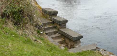
Ferry Steps, Alexandria
These steps are on the towpath outside the Craft wall about half way between Heather Avenue and Lumbrain Hole. They are a reminder of a ferry, which used to cross the Leven carrying workers between Milton Terrace and Works, and the UTR works at the Croft. They were built about the same time as the Jamestown Terraces in the 1850's / 60's.
The steps on the east side, in the old Lower Milton Works disappeared when that site was tidied up and converted into walkway in the 1980's. The metal rings for tying the ferryboats to are still on the steps.
Ferryfield Works, Alexandria
This textile factory in Alexandria just north of Bonhill Bridge was sited on what became the grounds of Our Lady and Saint Marks in 1926 and Saint Mary's School shortly thereafter. Since the 1990's, a private housing estate has occupied the remainder of the site.
Ferryfield Works were established in 1785 but most of the buildings dated from 1850's onwards. It became part of the Calico Printers Association group in 1906, and from then on the writing was on the wall. The Works closed in 1915 and were demolished ten years later in 1925 to be cleared for the building of Our Lady and St Mark's Church, which moved there from North Street in 1926. It has no connection with the site of the new housing estate at Sandbank, which the developer has called Ferry Fields.
Findlay Corner, Alexandria
This is the building at the north corner of Main Street and Gilmour Street which now houses the Halo hairdressers, Coyle’s fishmongers and the Post Office and store shop. It was built in 1880 and takes its name from its owner, John Findlay, who was a spirit merchant i.e. publican at 110-108 Main Street in that building. This was a pub right down to the 1960’s, latterly Flannigan’s Fountain Bar.
Finlas, Glen and Water
This Glen on Loch Lomondside, which lies just north of the new military road through Glen Fruin at its junction with the A82, houses the main part of the Vale's water supply and has done so since 1909. The Finlas stream, which rises at about 1,800 ft, at the north west end of the Glen, was dammed to create a reservoir, which is also fed by springs in the Glen. An abundant rainfall also helps of course. The stream then runs down into the Loch.
Finnich Toll, Croftamie
This was an old toll and toll house about a mile south of Croftamie on the Glasgow - Drymen Stockiemuir Road, just at the cross roads where the road to Killearn goes off to the east, and the Cameron Muir road or track goes off to the west, and eventually, the Vale. No trace of the original toll house remains, but Finnich features in the history of the Vale in the Depression Years of the 1920's and 30's, when many had no other pastime but walking. It was a way mark en route to the Devils Pulpit or the Whangie.
Firkin Point and Toll, Loch Lomondside
Located between Inverbeg and Tarbet, Firkin Point is a promontory on the Loch round which ran the original Lochside Military road, later the A82. The new A82 cuts right through a hill and by-passes Firkin Point completely. This has provided space for a picnic area and to see the old Tollhouse, for long a private residence, which stands on the former A82. Colquhoun of Luss owned the toll, like all other others in that area.
There are at least two possible derivations for Firkin, both of which are Gaelic. Firstly, there is “Firichean” for moor or hill-land, which is a good description of the surrounding area. John Barrington in his book, “Loch Lomond and the Trossachs” suggests that it derives from “Feidh Ceann” or Deer Point because deer used to graze there.
First, Second & Third Avenues, Dalmonach
These three names, which date from the original building of Dalmonach housing estate in the late 1940's, represent the only failure of imagination on the part of the street namers in the whole of the Vale. Even the way-out names, which appeared from the 1980's, have the major advantage of being highly imaginative. To begin with, most of the houses on these Dalmonach Avenues were aluminiums, but they were replaced in the 19860's by the present houses.
Fisherwood Road, Balloch
This short road runs from Balloch Road at Balloch Station, parallel to the railway, and now stops at Lomond Road. Tullichewan Hotel stands on its corner and the villas, which occupy one side of the Road (the other side is the railway line), were built conveniently close to the railway line to attract Glasgow businessmen. It was built in late Victorian / early Edwardian times and used to include Fisherwood House.
The building of the New Bridge and Lomond Road in 1935-6, cut across Fisherwood Road, marooning Fisherwood House. Cruach Villa was the name of the house on Fisherwood Road that was demolished to make way for Lomond Road.
Fisherwood, Balloch
This wood is located on the west bank of the Leven, immediately south of the New Bridge at Balloch and lies between the Bridge and the River Leven barrage. Both the Angling and Rowing Club clubhouses stand in Fisherwood. It is called after the fishermen who, from the middle ages onwards, had the right to draw nets across the river to catch salmon and sea trout. This right was originally given in 1224 by the Earl of Lennox to the monks of Paisley to draw nets, dry the nets and build houses and shielings for the fishermen.
The original grants from 1224 and 1225 specifically mention Lynbren and Dalmonach, but the fisheries expanded over the centuries. Each place at which the nets could be drawn was called a “shot” and there were a number of them on the bank at Fisherwood. How these rights were passed down after the Reformation is not clear, but by the 19th century the two parties with rights on the Leven were Dumbarton Town Council and the Colquhoun Trustees. The Colquhoun Trustees rented the rights out to locals, and there was a lot of money to be made from working a shot.
The formation of the Loch Lomond Angling Improvement Association, as it is now known, ended the fish netting on the Leven. Attempts began in 1860 to form the Association, but it took until 1895 to achieve its present form. However, in 1882 an interim Angling Association got the lease of the salmon fishing on the Leven between Balloch Bridge and its confluence with the Clyde and the Leven netting shots were closed down as a measure of stock conservation.
The fishermen of Fisherwood disappeared, at least until their spiritual descendants, the Vale of Leven and District Angling Club, acquired the Fisherwood land in 1948 and built a wooden clubhouse, which was replaced in 1972 by the present one.
Fountain Place, Alexandria
This lies on the south side of the square around the Fountain, and is the building, which joins Bank Street and Main Street. It was built about 1850, when it replaced old buildings from the early 1800's, which had replaced a small farmstead.
Fountain Street, Alexandria
Fountain Street was what Gilmour Street was originally called, when it was first laid out in the 1870's to connect with the new Middleton Street, which was by then under construction. William Ewing-Gilmour was one of the better employers in the Vale, and while competition for that title was hardly of Olympic proportions, a good man should get his due recognition. Also, his wife was a daughter of James Campbell of Tullichewan, so her instincts were also in the right place.
Ewing-Gilmour donated the Gilmour Institute (1884) as a place where men could go to read newspapers, borrow books, and generally consider the state of the world. The story goes that his wife was only half impressed with this, asking “but what about the women?” So a hundred yards or so further up Fountain Street, the Institute for Young Ladies was opened in 1891. Both of these red sandstone buildings are impressive by any standards. They were also just about the only buildings in the Street.
It did not take much imagination, which was probably just as well, for the Council to decide to rename Fountain Street, Gilmour Street. Both buildings still enhance the Vale scene, although neither quite serves their original purpose. In 1927, the old Bonhill Parish Council moved its offices from the Constitutional Club building in Bank Street to the Gilmour Institute. When the District Council was formed in 1929 it took over the Parish Council premises as well as most of its functions. The Library and Registrar also moved in there. To-day, the building is primarily Alexandria Library.
In 1921 the Institute for Young ladies became the Masonic Temple, which it has remained. Having a Street named after him was not the only honour that the Vale bestowed on William Ewing-Gilmour. When the Vale FC moved into the newly-built Millburn Park in 1888, William Ewing-Gilmour was given the distinction of kicking off the first match.
Fountain, The, Alexandria
The Fountain stands at the heart of Alexandria, where Bank Street and Main Street meet. It was erected in 1870 just a few feet from where the Oak Tree, the symbolic centre of the community, had stood even before Alexandria was founded, and gives continuity from these olden times. The Oak Tree and Fountain have traditionally been the place where political, religious and social meetings took place. Until quite recently people gathered there to bring in the bells on New Year's Eve.
After the Oak Tree had been cut down on safety grounds in October 1865, it left quite a gap in the middle of the town. Sundry local worthies came up with the idea of filling it with a monument to Alexander Smollett, local laird and MP for Dunbartonshire from 1841 - 1859. Famed for his incoherence and then silence in Parliament, and the owner of the hated and illegal Bawbee Brig just a few hundred yards away at the bottom of Bank Street, he was according to his “admirers in the county” a “kind and just landlord”.
Subscriptions were sought, funds were raised, and local builder William Barlas built the monument. The unveiling ceremony was slightly marred by only one unfortunate occurrence - most of the worthies didn't know that there was a champagne lake on the go, and instead over-indulged on more plebeian beer. That seemed to be the grudging memory of many who attended, which is proof, if any were needed, that some things never change in public affairs.
Front of Balloch, Balloch
This is the local name for that part of Balloch Road between Dalvait Road and Balloch Bridge, and in particular the more built up south side of the road - sometimes it is extended up to the bus stance. It probably got its name because it was the first part of Balloch to have houses and shops built on it, from the 1820's and 30's onwards, with the advent of tourism and the railway.
There is no corresponding “Back of Balloch”. On the south side of the Front of Balloch, the overall appearance and skyline have barely changed in 100 years, although obviously the detailed layouts and occupants of the various properties have. The Bus Stance was built in the early 1930's, and brought many day-trippers to Balloch on summer weekends, particularly in the 1940's, 50's and 60's. From the late 1940's adjacent to the bus stance was a detached villa, which was used as a café in the summer months. After the café closed the building was used for many years as a Bank of Scotland branch. It is a private house now.
A few yards down, entered across a small yard was a lean-to, which housed a transport café or drivers “howff”, mainly for drivers and conductresses on their 15-minute break at the Bus Stance. It eventually moved for a number of years in the early 1960's to a site in Dalvait Road in what became the Dog House. Next to the lean-to, what is now the Loch Lomond Gift Shop was a private house. On the eastern corner of Dalvait Road was Blair & Turner, a licenced grocery that was owned by Walter Grieve. This is now McCann's the hairdressers.
The west corner was occupied by the Cosy Corner Tearoom, which was owned by Rosa Rocchiccioli. She sold it to Jimmy Goodwin in the 1960's and it became The Dog House bar and lounge, which it has been ever since, although it has passed through various owners' hands since then.
Sinclair's Tea Room was the first business in the next building, and Mr Sinclair sold it to Anna Walsh, who operated it as a Tea Room for over 30 years. It is now Corrie's. In what became Pat Malloy's Fish & Chip shop, and is now an extended Palombo's of Balloch Fish and Pizza Restaurant, were a bank and fruiterers for a time in the 1940's and early 1950's. Where the Chinese takeaway now is was a private house. Then next to that from about 1950 onwards was Arcari's Café, behind which Freddy Arcari had built a brand new dance hall, or if you prefer, and Freddy certainly did, a ballroom.
This was the social centre of not just the Vale, but also much of western Clydeside. As Freddy had spotted, the next bona fide ballroom was in the west end of Glasgow. Arcari's was very well appointed, with an excellent dance floor, a bandstand that made most bands imagine they were Glen Miller playing Carnegie Hall, atmospheric lighting, and tight security. About half the population of the Vale were conceived as a result of relationships started in Arcari's - they mostly turned out to be married relationships, by the way.
Its hard to remember that Freddy was only in Balloch for just over 10 years, the fun seemed to last much longer than that. When he sold up and moved on to his next venture (he was successful at most things he did), the ballroom didn't last very long. Shortly after being sold, it burned down, and the ballroom was never rebuilt. The site is now Robert Dawson and family's popular Waterhouse pub and restaurant.
The final shop in the tenement row of buildings is now Pacific Wizgonies hairdressers and café, but Freddy Arcari also at one time owned it and there was a fish and chip shop in it. The detached houses to the west of the shops were from about 1920 until the mid 1960's, Balloch Police Station. The final building on the south side of the Front had been belonged to Balloch Hotel. It housed their stables, a dairy and dance hall. It is said that the last dance to be held in it was in 1918, a dance to celebrate the end of the First World War.
Sometime in the 1920's it became a garage. Wull Aitken owned it until about 1960, when it was bought by Harry Lynn who passed it to his son Tom Lynn, who sold it to John Glen. It was demolished about 2004 to make way for flats, but the site has lain empty since then. Across the road from this gap site, on the north side of the Front, is the Balloch Hotel. This is the oldest building on the Front of Balloch and the oldest licenced premises in the Vale. Parts of the present building date from 1820, but there has been an Inn on that site since time immemorial, servicing travellers using the Balloch Ferry or Boat as it was sometimes called.
Later Hotel customer included the Empress Eugenie of France in 1860, wife of Napoleon's nephew, who was France's last monarch. For many years thereafter the Empresses' name was shamelessly used by the Hotel in its advertising. The public bar of the Hotel was a very busy place in the 1940 –60's with locals and boating people. The Hotel's Jack of Diamonds lounge, upstairs from the public bar, managed to carve out a niche for itself in the 1960's and 70's, especially after the demise of Arcari's, as the local music venue of choice.
What is now St Kessog's Church Hall was originally the Hotel Tea Room, and while St Kessog's was under construction, it was used as a Church for some months. St Kessog's Church itself opened in 1952. Adjacent to the Church is Moss o' Balloch and the Park there was the site of the annual Moss o' Balloch Fair and Horse Market, which drew dealers from all over Scotland and crowds from the Vale for about a century and a half - the last one was 1919, but it was played out before that.
The Park was a football field of mediocre quality, and was used for about 30 years from 1967 as the venue for Balloch Highland Games. Now each summer the Moss o Balloch hosts the Balloch Folk Festival. The part of the Park nearest the Road is now being promoted as a sort of Balloch Village Square.
There are two stand-alone buildings to the east of this area. The reconstruction of the first of these has now been completed, and it has opened as a fast food take-away with a predominance of Indian food. It is appropriately enough called Chillies. However that building started life in the 1950's as an oversized large wooden hut, This housed a bank sub branch, which opened a few days a week.
There can be no greater example of the “then and now” contrast of life in the Vale 50 years ago compared to now than the fact that a teller came on the ordinary service bus from Alexandria carrying the monies to be used in the branch that day. The teller was accompanied by a retired policeman as a security guard, but everyone knew who they were and what buses they caught. There were no incidents.
When the Bank gave up, the hut was used as a woollen goods shop for a number of years before its present use. The second building, which is now the Key Store, stands on the site of a hut, which was built in the 1920's to sell nursery produce. By the 1940's and 50's, it was a combination of a sweet shop and a house. It was about a quarter of the size that it is now. It was at that time owned by the Sloan family who sold it to the Fife's in the 1950's.
In the early 1960's, the daughter of Harry McGhee, the Glasgow businessman who had bought Paddy Caulfield's house and converted it to the Lennoxbank House Hotel, bought this hut. She expanded the role and size of the shop into something like what it is to day, calling it The Tourist House. Although it has gone through a number of owners since the 1960's, it is still recognizable as the general store that it became at that time.
Fruin, River & Glen
The name Fruin may be derived from the Gaelic “freoine rage”, meaning raging stream. The Fruin Water rises at about 1,500 feet, just 2 miles north east of Garelochhead, and then instead of taking a short drop into the Gareloch to the west, it turns to meander about 12.5 miles in a south-easterly direction to flow into Loch Lomond just a few yards north of Arden, almost immediately opposite the south end of Inchmurrin, and 2.25 miles north of Balloch pier. It flows through Glen Fruin which not only has sad historical connections, but which has for over a hundred years been a popular cycling, walking and fishing destination for Vale folk. Youngsters especially liked swimming in Craig's pool.
In Glen Fruin in February 1603 was fought the last clan battle in Scotland, between bitter enemies the Colquhouns and the McGregors, and although documentary evidence from that time is very good for most things, many of the details of the battle remain at best disputed and in reality unknown. It is not known, for instance, exactly where the battle took place, although a site near to Strone Farm at the northwest end of the Glen remains favourite. Nor exactly how many took part, although figures of 400 McGregors and about 800 Colquhouns (of whom 300 were horsemen) are quoted.
Did a group of pupils from Dumbarton Grammar School really come to spectate at the battle, and if they did, were they really massacred? Were 140 Colquhouns killed as against 2/3 McGregors? What is agreed is that the McGregors won, killing a lot of Colquhouns in the process, and that the Colquhouns protested to King James VI, (who shortly thereafter became King James I of the United Kingdom). He definitely was so appalled that he outlawed the Clan McGregor en masse and banned the use of the name Gregor or McGregor. They remained banned until 1661 in spite of being among the Stuarts' most loyal supporters.
In more modern times, where the Fruin entered the Loch was known as the Fruin Shore. It had a sandy beach and was a very popular destination at the weekend with boating people from Balloch, particularly people who had to row up from the Leven. Although the mouth of the Fruin was changed to suit sand extraction, the Fruin Shore survived. Its south-facing shore was for many years the start of perhaps the most picturesque 2,000-meter rowing course in the world, home of the Scottish Championships until the 1960's.
![]()