Place Names (T) Talbot Road - Turnbull's Loan
Talbot Road, Haldane
This short road in the Haldane dates from about 1954. There are two Peter Talbots who served on local councils at different times – one from the pre-1895 Bonhill Parochial Council, so he can be discounted as being the source. Instead, the Road is named after the Peter Talbot who was the shortest-serving Chairman of any of the local councils. He stood for election to Bonhill Parish Council firstly for Alexandria West, receiving the endorsement of the Vale of Leven Trades Council, in the 1919 election but came 3rd in the 2 councillor seat.
In 1922 he transferred to Alexandria East and comfortably topped the poll in the 3 councillor ward. At the first meeting of the new Council, the famous 1922-25 Bonhill Parish Council, in December 1922, he was elected chairman of the Council. However, he did not serve long, resigning in February 1923 i.e. after 6 weeks, from both the Chairmanship and from the Council itself. In those 6 weeks, the BPC had confronted the central government on the issue of increased payments of Poor Relief and it was clear to all that stormy times lay ahead. In his letter of resignation Peter Talbot cited business reasons for his resignation. He was replaced as Chairman by Adam Shearer and as Councillor by Angus McFarlane, both of whom also have streets in the Haldane named after them.
Tank Woods, Alexandria
These woods at the top (west side on the lower slopes of the western hill) of the Christie Park, got their name about 1860. It was then that a private company started the Vale's first centralised water supply. Water was collected from springs on Overtoun Muir and fed into a large covered metal tank, which was sited in the general area of where the reservoir now is i.e. beside the woods that were soon called after the Tank.
This Tank could hold about 70,000 gallons of water, and water was distributed via iron pipes to upright wells in the street. It was a bit primitive, and the Tank was replaced by a new reservoir in 1879 (the private company had been replaced by the Local Authority in 1869). A further development was the pumping of water from the Loch at Drumkinnon Bay into the reservoir at Overton, which started in 1882. This had drawbacks, including the cost of continuous pumping and pollution from Lochside houses and the steamers.
In 1909, the Vale built the scheme that still operates - a dam in Glen Finlas feeds the existing, enlarged reservoir. Pumping from the Loch in Drumkinnon Bay stopped in 1909. The pump-house was sold to the railway company who used it as the winch-house for the slipway, which had been built about 1902. It is still standing. The company that owns the Maid of the Loch has bought both it and the slipway. The metal Tank? Well it was cut up for scrap in 1879, but the name Tank Woods has survived.
Tarbet, Loch Lomondside
This Lochside village lies at the junction of the A82 and the A83, about 16 mile north of Balloch by road, and about a mile and a quarter east of Arrochar and Loch Long. The name is Gaelic for an isthmus or portage point for dragging boats from one stretch of water to another across a narrow strip of land. Tarbert is just another spelling from the same origin, and indeed the first written record of Tarbet is in 1392 when it is spelled as Tarbert. There is an entry for Tarbet in the Loch Villages pages.
Targets, Auchincarroch Road
The Targets was the name given to a shooting range used mainly by the Territorials, but also during both of the World Wars by the many army units stationed locally. It was located in the field just beyond the north-eastern end of the Golf Course, and entered from Auchincarroch Road. The targets themselves were on the side of Auchincarroch Hill (now the landfill site) and soldiers shot up hill at them.
It was used from the late 19th century until the 1960's. When in use for rifle and bren-gun practice, a huge red flag which could be seen from a couple of miles away, and wouldn't have been out of place on top of the Kremlin, was hoisted to warn people off. The shooting could be heard all round the Vale.
Prior to this site being used, the old Volunteer movement of 1858 - 1911 had shooting ranges for each of the three Vale volunteer companies One was in a field adjacent to the Slunger at the other end of the Golf Course, another was at Woodside Farm on Auchincarroch Road, quite close to the Targets, and a third was on Millburn Farm and Carman Hill, above what is now Burnbrae.
Taurry Laun, Alexandria
The nickname for a flat-roofed tenement building that was near the western corner of Mitchell Street and Bank Street. Presumably it took its nickname from the tar, which would have been used to seal the roof.
Taylor Street, Tullichewan
The Lennox Herald of 14th March 1964 reports that the Council had decided to name this Street after William Taylor, who had had a joinery business for much of the earlier part of the 20th century in Tooraladdie, the short cut between Bridge Street and Bank Street. He had been involved in the building of some fine Vale houses both detached and tenement as well as much Council work. He was also a Councillor on Bonhill Parish Council for a time. Although he had a long standing Vale business with an outstanding reputation for quality, Taylor was almost unique in the 20th century in being a businessman and having a Street named after him. However, to be fair to the councillors who chose street names, they selected a number of deserving cases in the Tullichewan rebuild and expansion of the 1960’s and 70’s from the ranks of doctors, district nurses and council employees, so perhaps we shouldn’t be surprised at them choosing William Taylor.
The Terraces, Jamestown
Although there were, and indeed still are, many terraces in the Vale, to Vale folk “The Terraces” always referred to Levenbank, Milton and Napierston Terraces in Jamestown. This shorthand name seems to have been adopted as soon as Sir Archibald Orr-Ewing built the Terraces in the 1860's for his employees in Levenbank and Milton Works, and is still common currency to day, although the Terraces themselves were demolished in 1965-6 and 1976.
Thimble Street, Renton
This was and is one of the core streets in Renton and probably dates from the original laying out of the village in the 1760's. It originally ran from the Main Street to the river, but that line was interrupted by the developments of the 1960's when shops and flats cut across its western end, and closed it off as a through road to the river, leaving only its existing eastern stump at the riverside.
The name Thimble is certainly one of the most picturesque of any of the Vale streets, but we can only speculate at present on its origin. Perhaps thimbles were commonly used in the early textile process and were made there, or even a dress maker's / tailor's business was located there in the early days.
Thomas Street, Alexandria
This short street, which leads off Leven Street, probably dates from the time of the development of Bridge Street in the 1840's and 1850's. It was built on part of the old Parkneuk public park. In the twentieth century, there was a garage in Thomas Street, which survived until the redevelopment of the 1960's, when it and the few tenement houses on Thomas Street were demolished, to be replaced by the present houses.
Timbertown, Alexandria
This is the nickname which was given to Levenvale housing estate when it was being built in the mid 1930's. On a large pile of the wood, which was being used to build the timber houses, someone painted “Timbertown” and the name stuck for many years.
Tin Shed, The, Arden
This greyish shed stood for more than 50 years from the early 1900's, beside the Loch at Burnfoot, Arden. In fact it consisted mainly of slatted wood, with a corrugated iron roof, from which its name presumably derived. It was built to house a beautiful private steam launch, the last on the Loch, which was still making the occasional appearance in the 1960's. The shed was demolished about 30 years ago, but the launch had gone before that.
Tinker's Loan, Balloch
This is an ancient Right of Way. The part of the Tinker's Loan from Dumbain Farm down over the old Balloch - Stirling railway line and up the slope to end at Auchincarroch still survives intact. The rest of it has been subsumed into Dumbain Road and then Dumbain Crescent.
Until the mid 1950's the Loan ran up the south side of the blacksmith's shop at the old Mill of Haldane, on the south side of Ballagan Burn, to Dumbain Farm, where it joined the surviving track. Every year, in the summer and autumn, a family of travelling people erected their tents on a piece of open ground between the farm and the railway, and spent the summer and autumn mainly working on local farms, but also selling clothes pegs and heather door-to-door - with very few refusals because no one wanted a tinker's curse put upon them.
Children from the camp were still attending Jamestown school in the mid 1950's, but the pressure of the new Haldane estate, plus the changes in the travellers' way of life, saw the camp fall into disuse by the early 1960's. The remaining Loan remains a favourite walk, particularly with Haldane dog owners.
Tomato Lane, Balloch
This is the nickname for Mollanbowie Road, and comes from the fruit and vegetable nursery - Haldane Nursery - that stood more or less where the Mossburn Estate now is. Haldane Nursery closed in the late 1930's but the sign survived almost until Mossburn Avenue was built in the mid 1960's.
Tontine Park Estate, Renton
The Valley, as it is nicknamed, was built on the home park of Renton FC, long after the club went defunct about the turn of the 20th century. The houses were built about 1928, with a few added about 1950 at the extreme south end. The estate consists of two streets, Tontine Park and Tontine Crescent.
Tontine Park, Renton
The home of Renton FC, first Football Champions of the World. Formed in 1872, Renton FC became World Football Champions in 1888 by beating West Bromwich Albion 4-1 at Hampden in the clash for the title. Both teams qualified for the final by being the cup holders in their respective countries. This illustrious ground at the south end of Renton was actually the third park to be used by Renton. They had previously used a private park at the north end of Renton, and then in 1877 a park simply described as South Park, which could have been the Public Park or what was to become the Wylie Park.
Tontine Park is described by contemporaries as a compact ground, whose eastern boundary was a Dalquhurn Works lade, and punting a ball into the lade was an excellent way of running down the minutes if Renton were leading in a tight game. To begin with, the pavilion was 100 yards from the pitch, but in 1886 a new pavilion was opened on the ground.
Tontine served as Renton's home ground from 1878 until their demise in 1897, when they were declared bankrupt and dropped out of senior competition. They were finally disbanded in 1921. In the 1920's the County Council acquired it and houses were built on it in 1928 - the present Tontine Park estate of to day (see above). A plaque in the garden of a house in Tontine Crescent marked the centre spot of the pitch until quite recently, but has currently disappeared.
Tontine seems an odd name for the ground, because its main meaning is to describe a group savings scheme in which the survivor collects the accumulated savings. Maybe the Park was purchased via such a scheme, but we don't know.
Tooraladdie, Alexandria
This was the nickname for an alley, which was a very useful shortcut between Bridge Street and Bank Street. Long since disappeared under the roundabout road on the east side of the railway station, its Bridge Street end was almost opposite the Baptist Church. William Taylor had his joiner's shop in Tooraladdie Lane.
Towpath, The Leven
The original towpath was used by horses pulling boats up the Leven (hence “tow”). It started at about Dalquhurn and finished at Balloch Ferry, subsequently the old Bridge at Balloch. It is known that there was considerable trade up and down the river from at least the 14th century onwards, but we don't know when the towpath was actually built. The earliest visual record we have of it is the 1777 engraving of the Smollett Monument, when it seems to be about the height and width that it is to day.
The Leven was and is a navigable river in terms of Maritime Law, and therefore access to the towpath was open to all, and ownership, which was probably seen as having at least as many responsibilities and problems as benefits, was at best opaque by the time the cycle track was built on it in the 1980's. Before that, however, the factory owners treated it as their own - for instance when the UTR wanted to run a railway track into Cordale in 1885, they just extended the existing line into Dalquhurn along the towpath, although they lost a horse and cart into the river in the process.
After the Second World War, the towpath was in a state of considerable dilapidation, really just a series of joined up potholes. By then, the main users were fishermen and keen walkers. The building of barrage scheme at Balloch which lasted from 1967 - 71, saw part of the tow path coffered between the bottom of the Heather Avenue and the Angling Club at Fisherwood, and it being made up to a road quality surface.
In the 1980's, the Glasgow - Balloch cycle track used the towpath as its final six-mile stretch and it was brought up to its present reasonable standard. The building of the cycle track highlighted the fact that there were actually gaps in the towpath at either end of its route from Dumbarton to Balloch, where horses couldn't tow the boats upstream. Between Dumbarton and Dalquhurn this wasn't a great problem, because they could wait and come up on an incoming tide. Between Balloch Ferry and Loch Lomond, they probably poled or rowed the boats to the mouth of the Leven and onto the Loch.
Tudhope Crescent, Alexandria
This crescent in Tullichewan, dating from the 1960's was named after Dr Tudhope, a Vale GP.
Tullichewan Castle and Estate (Contributed by William Scobie)
During the Transvaal War, in 1880, the Boers, proclaiming a South African Republic, surrounded a number of British garrisons. A battalion of the Royal Scots Fusiliers, seasoned in the Zulu campaign of the previous year, defended a small fort on the south side of the besieged community of Pretoria. In command was Colonel, later Major General, George Gildea and he named the stronghold after his wife’s family mansion - Tullichewan Castle. Colonel Gildea and his wife’s home at the time was Bromley House, which was also part of the Tullichewan Estate.
There are two suggested meanings for the name Tullichewan. Firstly we have “Tulach Eoghain” - The Hill of Ewan - reputedly an Irish chieftain and an ancestor of the Earls of Lennox. Secondly there is the simpler “Tulach Uaine” meaning a green hill. The lands which we now spell as Tullichewan are part of one of the oldest estates and have one of the oldest names in the Vale. An early reference to the lands of Tullichewan is to be found in a charter of 1364. In this document Donald, 6th Earl of Lennox, grants the estate of “Tulewin” to Walter of Faslane. Subsequently, down through six centuries, these lands have had many and varied proprietors.
By 1543 it appears as 3 separate estates – Tilly-Colquhoun, Tillichewan–Dennistoun and Tillichewan-Semphill. Over the years it has shared with Linnbrain the title of the place in the Vale with most ways to spell its name, but of course that happens with older place names. Spellings have included Tillichewym (1654), Tilichewen (late 18th century), and Tillichewan (1876 and 1884). The simple rule is, if it looks and / or sounds like Tullichewan, then it is Tullichewan. Probably in the late 17th century they were consolidated into two estates – Little and Middle, one of which was owned by a branch of the Colquhouns of Luss.
Appearing in maps as early as 1654, the lands of Tullichewan as now understood lie along the western side of the Vale of Leven, effectively bounded by the hospital grounds in the south and the A811 to the north. Until the early 20th century, the grounds were larger than that, effectively running from what became Hill Street in the south to just north of Woodbank House in the north, and then due east, skirting the Cameron Estate to include a substantial Loch frontage around Drumkinnon Bay. West to east, the Estate ran from just below the ridge of the Stoneymollan hills in the west to the River Leven in the east. From Heather Avenue to the piers at Drumkinnon Bay, when the railway was built in the late 1840’s it bought over and ran through what had been Tullichewan fields and woods.
Originally in the parish of Luss (until it was transferred to the parish of Bonhill in 1643), Tullichewan passed to the Duke of Argyll. Then in 1568 the estate was obtained by James Colquhoun of Garscube, the first of a long line of Colquhouns to hold it over a period of around two hundred years. Robert David Colquhoun of Tullichewan in 1815 raised the 3rd Gurkha Rifles in Nepal, arising from which the pipers of the regiment adopted the Colquhoun tartan in 1928.
In the 18th century Tullichewan passed into the hands of Buchanans. Between 1792 and 1806 John Stirling of the Cordale textile family bought the lands from James and John Buchanan. At this time, therefore, Tullichewan which had been held by traditional local landed clans became an asset of the rising industrial and merchant class, in whose hands it largely stayed until the outbreak of WW2.
It was in 1808 that the Stirlings commissioned architect Robert Lugar to design the impressive mansion house which became Tullichewan Castle. Old maps indicate that an earlier building existed which may have been a tower-house. It is possible, therefore, that the mansion was erected at or near to the site of the  previous structure. Robert Lugar was an English architect who is still regarded as one of the leading designers of country houses and castles in England, Wales and Scotland in the first part of the 19th century. He designed Balloch Castle at the same time as he was working on Tullichewan, and later was the architect of the rebuilding of Boturich Castle in the 1830’s.
John Horrocks, whose fortune came from cotton manufacturing in Lancashire, bought the castle in 1817 and lived there for twenty years. A map drawn during his time shows the estate stretching right down to the River Leven at Balloch. The next owner was William Campbell, a Glasgow man of business, who also acquired the adjacent lands of Broomley, the house of which in 1924 became the Henry Brock Cottage Hospital. William also acquired Woodbank House and Auchendennan Estate at about the same time as he bought Tullichewan. Woodbank remained part of the Tullichewan lands until the sale of the estate in 1922, but William sold Auchendennan, on which stood the Italianate mansion called Bellretiro shortly before his death in 1864. William’s son inherited the estate and it was this James Campbell who became the father-in-law of Colonel Gildea of “Tullichewan Castle”, Pretoria. The Gildeas lived for a number of years in Broomley House (at different times Broomley is spelt “Bromley” at the whim of authors both official and private, but both spellings refer to the same mansion house). Another daughter was the wife of William Ewing Gilmour and they lived most of their married life at Woodbank.
In the twentieth century a flurry of owners and occupants held the real Tullichewan Castle. On the death of James Campbell it was let, in 1902, to William Beardmore, a shipbuilder with interests in Parkhead Forge and the Lancefield Engine Works, noted for his collection of automobiles. Around 1910 Tullichewan reverted to James Campbell’s son, William.
Throughout the First World War the house was occupied by the Lumsdens of Arden. In 1922 a grand auction of the whole Tullichewan Estate was held at the McLellan Galleries in Sauchiehall Street in Glasgow. The Estate was broken up and Tullichewan Castle and the land immediately surrounding it were bought by a William Anderson. It passed from him to Mr. James Scott Anderson until, at the outbreak of the Second World War, it was taken over by the Royal Navy.
It had already been designated as a training camp, but its first use was to house US personnel who were building an oil pipeline from Finnart to Old Kilpatrick where it connected to an existing pipeline to Grangemouth. The US staff built the huts etc in the camp and they were regarded as high class accommodation in comparison with those put up by the British military. As soon as the US Navy left, Wrens moved in and it became an induction training school for Wrens.
Only in recent years ex-Wrens who were stationed there have spoken of having been taken to the camp under great secrecy and said that on inquiry the Admiralty would supply only the scantiest of information regarding its true wartime purpose - which leaves the field open for interesting speculation. The official name of this posting during the war was “H.M.S. Tullichewan” then “HMS Spartiate II” and then back to being “HMS Tullichewan” *
Subsequently the Royal Naval Torpedo Factory said that it was going to use the Castle as a hostel for some of its key workers for a very short period after the war, although at this time there is no evidence that any workers actually boarded there. The Camp on the other hand was taken over by homeless Vale families who stayed there until about 1954. Many of the heads of the families were newly returned from serving in the forces to find the council unable to provide them with accommodation, so they took matters into their own hands.
In the post-war housing shortage a number of conventional and prefabricated houses were built at Tullichewan and they provided much-needed accommodation until the local authority building developments of the sixties. Some of the prefabs remained well into the seventies. Tullichewan Drive forms the axis, as it were, of this layout.
The Tullichewan Castle mansion house deteriorated and became an impractical burden before being demolished in April of 1954. Interestingly the nautical association continued even then with much of the resultant rubble being used for an extension of Glasgow’s King George V Dock. At its finest Tullichewan 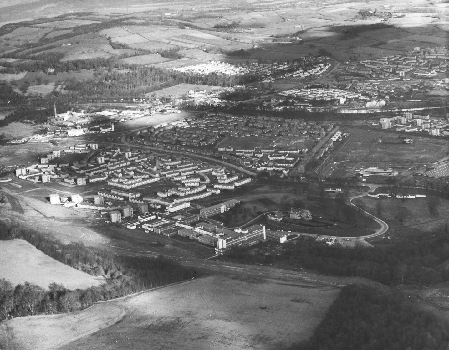 Castle had been surrounded by some beautiful gardens and parkland. Even after the destruction of the house a few particularly magnificent trees remained standing nearby, enhancing the look of that part of the hillside until they were sadly felled for the construction of the Alexandria A82 bypass. The stables can yet be seen from the road near the Stoneymollan roundabout.
Almost all of the land in this 1974 photo from the hillside at the bottom of the photo to the River Leven to-wards the top was part of Tullichewan Estate until the 1920’s. (The Alexandria bypass construction work is clearly visible cutting through the foreground of the image.)
Tullichewan today is a fairly unremarkable looking part of the Vale, but how many places can lay claim to the founder of a famous regiment, or having given their name to an African fort, been one of His Majesty’s Ships and supplied part of a world-renowned dockyard?
Note: It has come to light that many of the Wrens who were trained at H.M.S. Tullichewan were subsequently posted to the Government Communications Headquarters at Bletchley Park, which famously decoded Enigma, the German U-Boat code.
William Scobie
Tullichewan Crescent, Alexandria
Another of Tullichewan's “curtailed crescents” it dates originally from about 1950, but the present houses were built in the 1960's.
Tullichewan Housing Estate, Alexandria
The building of the first version of Tullichewan Housing Estate began in the late 1940's on what were some of the remaining large fields of Tullichewan Home Farm. It was also known as Black's Farm, after the farmer of the time (Black's farmhouse was in the middle of what is now Argyll Estate).
The first houses to be built in the housing estate were brick semi-detached and terraced house along the front of the Estate on Luss Road. They were completed about 1949. These houses are still standing. The rest of the estate spread out behind them in four semi-circles of aluminiums, each semi-circle being a crescent, with Tulliechewan Road bisecting the Crescents. The aluminiums were prefabricated by Blackburn at Dumbarton and quickly built on site. The “prefabs” or “aluminiums” as they were known, were innovative and very popular at the time, and they helped to start to solve the post war housing shortage.
The whole Tullichewan estate fitted well inside the semi-circle created by the roads from the north and south lodges to Tullichewan Castle, while the Castle itself was just one large field away to the west of the nearest houses. The prefabs were never meant to be permanent, and all the aluminiums in Tullichewan were torn down and replaced by brick-built housing. This second phase of building gave a far greater concentration of houses per acre, not least because each new building was at least two-storey. Even before the prefabs were replaced, most of the greenfield land in the Tullichewan Estate, not taken up by prefabs, was already being built upon by the late 1950's and early 1960's.
This was particularly true in the northwest corner of the Estate. After the completion of the prefab replacement, the first private houses were built in the 1970's. When plans for the second phase of private building were announced in the 1980's, they met strong local opposition. This was based on fears that the traffic from new houses could not be handled by the existing road system, particularly the exit onto Luss Road. Dumbarton-based councillors, on what was then Dumbarton District Council, eventually carried the day, and the houses were built.
Turnbull Avenue and Crescent, Alexandria
Both of these roads, one being a continuation of the other, in south east Burnbrae, were named after the Turnbull family who for a century or so from 1806 lived at the nearby Place of Bonhill. The Turnbulls owned the Millburn Pyroligneous Works, a chemical factory that was located just beyond Turnbull Avenue, for about 100 years. (This has been for 70 years or so Millburn Roads Depot). The old Dunbarton County Council built both roads in the 1920's.
Turnbull's / Trumbl's Loan
This road, with the Poachy Burn, is taken as the boundary between Renton and Alexandria and runs between Main Street and the River Leven. It is called after the Turnbull family, and in particular John Turnbull the patriarch, who was a partner in Cordale Works and who moved into Place of Bonhill House in 1806, completely restored it, and died there in 1817.
Other members of the family continued to have businesses in the area - a son, also named, John started the Millburn Pyroligneous Works on what is now the Millburn Roads Depot and it produced chemicals for use in the textile industry between 1790 and about 1900, while his son, Stewart, farmed about 600 acres in the Millburn area in the 2nd half of the 19th century. The family seems to have left the area in the early 1900's. Turnbull's Loan is now officially called Place of Bonhill.
![]()