Place Names (C) Cables Drive - Cullen Street
Cables Drive, Bonhill
This is one of the main roads in the Dalmonach estate and was built in the late 1940's. It runs from northern Main Street Bonhill almost opposite what had been the back gate of Dalmonach, in other words where the Cannon Row was, to Napierston Road and Woodside Crescent. Why it was called “Cables” has puzzled us for years, but Billy Scobie has come up with what seems a plausible and likely answer: that it was named after two Bonhill men who played quite different but key roles in the laying of the first Transatlantic telegraph cable and then other telegraph cables which circled the globe: Sir John Pender, who provided some of the money and much of the drive, and Donald McFarlane who was Lord Kelvin’s assistant and helped him solve many of the technical problems associated with transmission over such a long distance. The two county councillors for the area – Bonhill and Braehead – when the road was being named were Hugh McIntyre and Dan O’Hare respectively and it’s not hard to imagine that they would have liked to find a more subtle way of recognising the great achievement than naming it after Sir John Pender.
Calabria Road, Mossburn Estate, Balloch.
How on earth did this place name pop up in Balloch, so far from its home at the toe of southern Italy? Hopefully someone will provide the correct answer, but at a guess, Calabria lay at the heart of the Italian diaspora of the late 19th / early 20th century, probably providing more emigrants per head of population than any other part of Italy. As is well known, many came to Scotland and many to the Vale. Perhaps one of them had a hand in naming this Road in honour of their homeland, and no, the fact that Gennaro Gattuso, the ex-Rangers player and World Cup winner, comes from Calabria definitely has nothing to do with it.
Calamoon Wood, Alexandria
This wood lay between the bottom of the Heather Avenue and Fisherwood in an area probably best described as including the northern part of Rosshead and the area known as the Big Muddy, north to where the Barrage control station and Rowing Club now are. It was probably cut down when the Balloch-Stirling railway line was built 1855-56.
Caldarvan, Gartocharn
This is the name of the area to the east of Gartocharn around the curve of the Horseshoe road. It gave its name to Gartocharn Station on the Balloch-Stirling railway line. The name, like many others around it, dates back for centuries, and sometimes appears as Caldarven. In 1802, the McKenzie family, until then Glasgow merchants, bought Caldarvan House and have been farming in the area ever since. Admiral McKenzie lived in Caldarvan House in the early part of the 20th century.
Cameron Brae, Balloch
Most of this brae on the old A82 / Old Luss Road still exists, although on its northern side it merges into the pavement of the new A82, and therefore represents the end of Old Luss Road about half a mile north of the Balloch Loan roundabout. It did not feature at all on the original Dumbarton - Inverary military road (which was made up into the A82). The line of that road originally kept to lower ground much nearer the Loch. However, since it went right past the front door of the Smollett's new Cameron House, they paid to get it moved behind the house, and Cameron Brae came into being.
It was a noted hazard on the A82 for two reasons. In addition to it being a fairly modest hill there was a Z-bend on it, also the camber ran the wrong way. There were many accidents on it, a number of them fatal, and it was particularly unforgiving to motorcyclists. If the new A82 did nothing else, it removed this accident spot.
Cameron Drive, Tullichewan
This road in Tullichewan was built in the second phase of building at Tullichewan in the late 1950's - early 1960's. It is called after the nearby Cameron Estate of the Smollett family.
Cameron Estate & House, Balloch
The House was built at the landward end of a small peninsular into Loch Lomond, Cameron Point, from which the Estate derives its name. The name Cameron, like so many place names around the Loch, originates in Gaelic. This crooked piece of land, which is Cameron Point, attracted the name “crooked nose” which in Gaelic is “cam sron”, which has elided to Cameron. There is absolutely no connection with Clan Cameron or the Cameron family.
The land has been inhabited since early times, because the presence of two crannogs in Cameron Bay has been confirmed in recent years. The lighthouse sits on one - it had previously just been thought to be an ornamental or navigational cairn. The Smolletts, who at that time were living at the Place of Bonhill, bought Cameron Estate in 1762 (some historians say 1763).
The existing house on the estate was old, with cellars dating back to the 15th century, and the Smolletts set about major renovations and rebuilding of the house. Tobias Smollett, the writer, visited in 1766, while Dr Johnson and Boswell spent a night there in 1773, the day after they had visited Rossdhu. Johnson said that “here they had more solid conversation than at any other place they had been” on their tour to the Hebrides. That was quite a compliment from Johnson, and perhaps encouraged him to give the Smolletts some wording for the inscription on the memorial to Tobias Smollett, which was erected in Renton in 1774 (The Smollett Monument).
A new frontage was added in 1806, and about that time, the Dumbarton - Inverary military road, which passed the front door, was moved to the line of the old A82, including the old Cameron Brae. The main driveway alongside the Loch, which now goes past the marina and golf course, is the old military road. The House was considerably altered and expanded, especially after a major fire in 1865.
In 1972 a Bear Park was opened in the grounds of Cameron House. It was moderately successful for a time, but by 1986 its days were over. The estate and house were sold by the Smolletts, and were converted to a hotel. Timeshare lodges, a marina and a nine-hole golf course followed.
Cameron House itself was considerably altered, with the addition of bedrooms, function suites and a spa, but is still recognisable as the Cameron House of old. It is now the De Vere Cameron House Hotel and attracts many prominent clients including Clint Eastwood, the late Pavarotti, and the Scottish international football squad who use it as a base in the run up to internationals at Hampden.
Cameron Muir, Croftamie
Cameron Muir lies between the Drymen - Glasgow Stockiemuir Road just east of Croftamie, and the Horseshoe road. There is a walkable trail from where the Horseshoe turns north coming from Bonhill to the Stockiemuir Road, going over Cameron Muir and meeting the Stockiemuir Road at Finnich Toll.
Cameron's Park, Alexandria
This was the very first home of Vale of Leven Football Club for a short time after its formation in 1872.
The Vale certainly played Queen's Park on 11th January 1873 at Cameron's Park in what was billed as “the opening of Vale's home ground - Cameron's Park.” We can no longer be sure of its location, other than that it was in Doctor's Loan. We now know that Doctor’s Loan was what became known as either Upper Bridge Street or Upper Smollett Street. That being the case, Cameron’s Park could have been in the area where Queen Street now is and where Bridge Street Church was or, if it was in Upper Smollett Street on the piece of ground which later became Schoolhouse Park and after that the Tennis Courts. Whichever of these sites it may have been, it has long since been built on.
The Vale soon moved to North Street Park, which was the ground on which they had their Scottish Cup glory years, and in 1888 to Millburn, their 3rd ground, which is where they still are.
Campbell Crescent, Alexandria
This was another of Tullichewan's “curtailed crescents” (see Broomley Crescent) originally dating from about 1950. The present houses there date from the 1960's. It is named after James Campbell, owner of Tullichewan Castle in the latter part of the 19th Century. He was a full cousin of the Liberal Prime Minister, Sir Henry Campbell Bannerman who was a frequent guest at Tullichewan Castle, as were others such as the Italian freedom fighter Garibaldi. Campbell was not a local employer, but was correctly seen as a Vale “man of the people” in his day.
Campbell Street, Bonhill
After the Burn and Main Street, Campbell and Croft Streets are probably the oldest streets in Bonhill, and these four streets make up the core of the early industrial village. Campbell Street runs due east at the top of the brae to connect with the end of the much newer George Street. It probably dates from about 1800.
Camstradden House, Luss
This House lies just to the north of Camstradden Bay, and it was originally the factor's house for the Colquhoun Estate. Since converting Rossdhu Estate to the golf club and Rossdhu House to the Clubhouse in the early 1990's, it has been home to Colquhoun of Luss. It was at Camstradden that Sir Ivar Colquhoun of Luss died in January 2008.
Camstradden, Luss
Camstradden Bay lies on the west side of Loch Lomond about three quarters of a mile south of Luss village, opposite the north end of Inchtavannach. It used to be thought that there had been an island in the Bay on which there was an ancient residence of the Colquhouns surrounded by a fine garden, and that all that remained of it was a pile of stones visible only at low water, and indeed the Ordnance Gazetteer of 1884 reported as much. Also, Camden in his Atlas Britannica describes an island in his day with a house and orchard.
However, modern underwater archaeology searches conducted by divers on two shallow stretches in the bay have found no trace of any habitation. It does have an interesting history nonetheless, because of the slate quarries in the adjacent hill. Slate quarrying was carried out from the 1790's until the 1930's and the slates were mainly carried away from the quays, still visible, in the Bay by scows, a steam puffer and barges to, Balloch railhead and beyond.
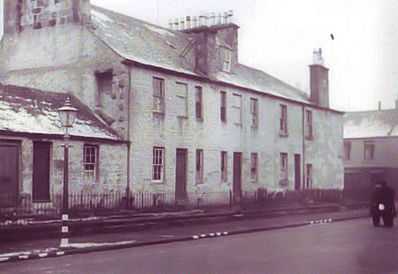
Cannon Row, Bonhill
Long gone, demolished in the late 1920's/ early 30's, this row of houses, two-storey with attics, stood on the Bonhill - Jamestown Road, almost opposite the back gate to Dalmonach, just about where Cables Drive now joins the main road. Considering how it turned out, it is hard to believe that when it was built in the early 1830's it was called Church Row, after the nearby Mount Zion Relief Church, which had opened in 1831.
There are a number of explanations for how it acquired the name Cannon Row, the most colourful being that the women of each house often used to hang out of her window to abuse passers-by, and this looked just like cannons poking through gun ports on men-of-war sailing ships. And why not? Possibly called after an owner of the buildings at some stage, a record of whom has long since disappeared.
Cardross Road Renton
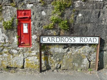 This road over Carman Hill to Cardross from
Main Street Renton goes back well before the formation of Renton in 1762,
although when Renton was founded Cardross Road was the village's
informal northern boundary, there being no houses beyond it to begin
with.
This road over Carman Hill to Cardross from
Main Street Renton goes back well before the formation of Renton in 1762,
although when Renton was founded Cardross Road was the village's
informal northern boundary, there being no houses beyond it to begin
with.
Before that, there were just a few houses in the area, but since they belonged to Cardross Parish rather than Bonhill, people had to walk over the Hill to the old Cardross Parish Church.
The Road comes down into Cardross more or less alongside the ruined Church (a victim of German bombs rather than old age or old Rentonians). It would have been a track, but as Renton grew Rentonians of all persuasions used it increasingly since they had to register all births, marriages and deaths in Cardross. It also became increasingly busy as a drove road especially after the Cattle Fair moved to Carman Muir about 1800. Nowadays it is mainly used as a short cut to Cardross Crematorium or as a means of avoiding the bottleneck of Dalreoch traffic lights.
Carman Hill & Muir, Renton
This area of moorland and hillside above Renton has a lot of history associated with it. Firstly, and the oldest site so far found on Carman, is the vitrified fort at the top of Carman Hill (which is also sometimes called Mount Mallow by locals).
This fort, known as the “Standing Stones”, although the “lying stones” is a lot more accurate description, was only identified in the 1930's by aerial photography. It has never been archaeologically excavated and views on its dating and purpose have changed over the years. Current thinking is that it is post-Roman dating from the Dark Ages, and that would fit in with an ancient British name - Car derives from the ancient British / Welsh for caer meaning fort.
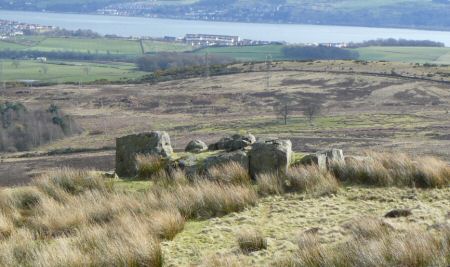
Mount Mallow's Standing Stones with the river Clyde in the background
It was a larger enough settlement, covering 6 acres. Although it was lost to modern history, Carman featured in the ancient poet Blind Harry's poetic “biography” of William Wallace. He says that there was a tunnel from Wallace's Cave at Havoc, up onto Carman Hill, and that Wallace escaped from the English through that tunnel. If it existed, it has been lost, though to be fair there has been no major attempt to find it.
Historians believe that Blind Harry was using poetic licence. Just below the Fort is a disused quarry from which red sandstone was taken for some of the buildings in Renton. Just a few years ago, a contractor wanted to use the quarry as a landfill site, but that idea was quickly knocked on the head.
The Hill is the southern end of the western ridge of the Vale of Leven. A drove road ran along that ridge from Glen Fruin via Stoneymollan to Carman Hill, down which it descended to cross Cardross Road and arrive at its destination - Carman Muir. On Carman Muir each June was held what had started as Dumbarton Cattle and Horse Fair, on a site at Townend. The expansion of the glassworks in Dumbarton in 1777 meant that it had to move up onto Dumbarton Muir, close to the Pappert Well and actually in Bonhill Parish. It stayed there for a number of years, but that site was not very accessible to the general public, so it moved again to Carman Muir, and finished its days there.
By that time it was known as Renton or Carman Cattle Fair. It attracted drovers from near and far and was important enough to be reported in the London papers. Its site just to the north west of Renton dam is still quite discernible in the heather as are the drove roads coming to it in all directions. While the Fair was on, the shepherd's cottage, now gone, but still standing until the 1930's, acted as a pub (without a licence) and Renton was a bit like a Wild West cattle town for a few days each June.
After the railway arrived in 1850, special trains were run to bring people to the Fair. Mayhem was never far away, and 1856 seems to have been a particularly violent time, with religion playing a part. Rail transportation of cattle killed these fairs, and the 1896 Renton Cattle Fair was the last one.
Before then, in 1886 Renton had built a brand new water supply fed by a new reservoir created at Carman Loch, adjacent to the cattle fair ground. This became known as the Renton Dam, and it remained quite separate from the Vale supply system until the 1950's - because Renton was part of Cardross Parish council as opposed to Bonhill, and “opposed” is probably an appropriate word.
The Dam, still called Carman Reservoir, no longer feeds the water supply, but is a very successful fishery. Just across the road from it, also on Carman Muir, the local model aeroplane club has flown its planes for many years. The whole area is excellent for hill walking, much of it signposted.
Carman Road, Renton
This road suffered a doubly whammy in the 1960's and 70's firstly from redevelopment, when all of its old buildings were pulled down and secondly from the building of the bypass, when it was decided to save some money by building only a footbridge over the bypass instead of a vehicle bridge. It puts “progress” into some sort of context, because when the railway arrived in Renton in 1850, a full vehicle bridge carried Carman Road over it.
Carman Road is therefore a cut down version of its former self, a one-sided road caught between the new school and the Renton Bowling Green, and its name usurped on the short stretch on which new houses now stand. To begin with, it was a track up onto the hillside, to a farmstead and shepherd's cottage, which wended its way over Carman Muir to meet Cardross Road - in fact a public footpath still allows the walker to follow that route.
By the mid 19th century, a quarry was worked close to the road providing stone for some of the Renton houses, and also for the fine mansions which were built on either side of Carman Road about 1880 onwards, and which are now accessed from Cardross Road. It was the most direct route from the village to the Renton Cattle Fair, and for a few days each year it must have seen many strange sights. Perhaps its no coincidence that the building of the large houses only started when the Cattle Fair was clearly in terminal decline.
Carmona Drive, Haldane
This road runs on the southern perimeter of the Haldane estate, and was built in the mid 1950's. By then perhaps all the easy street names had been taken, and someone was hard at work cobbling plausible ones together. Carmona has a hint of Carman to it and that may be the source of the name. Either that or some council official in 1955 had just come back from a visit to Seville - Carmona is a town near Seville. It is certainly the only Spanish town to have a street named after it in the Vale.
Contributed 20 June 2008
"Re your entry for Carmona Drive Haldane and the origin of this name on the valeofleven.org site.
Susan Louise Kirkpatrick-Chalmers DA ARMS was a well known local artist, she was principal teacher of art at Bearsden Academy for many years. She was the only daughter of Rosina and Andrew Kirkpatrick mentioned for Kirkpatrick Crescent, Alexandria. This street is named after Rosie Kirkpatrick, Labour County Councillor for Levenvale and Tullichewan for many years from the 1930's to the 1960's. She lived in Lansbury Street and represented the area in which a street is named after her. Rosie was one of the first women to be elected to the Council not only in the Vale, but also in Dunbartonshire.Mr Kirkpatrick had a large motor cruiser on Loch Lomond called "CARMONA" and the street where I now live is named after that boat. Susan and I were friends for many years before her death and she often recalled her time as a young girl on the Carmona sketching Loch Lomond. She told me her mother had chosen that name out of her love of Loch Lomond.
Many thanks
David Keown
Carmona Drive
Carrochan Burn, Jamestown
This burn rises close to Caldarvan and then runs westwards to Jamestown along a valley bed, and into the Leven just north of the Stirling Bridge - just under three miles in all. Along the way, a number of streams join from both north and south - the southerly ones coming off the Auchincarroch hills, and the largest of these is the Blairvault Burn. These burns have been a source of pollution in recent years with farmer's slurry overflowing into them and polluting the Carrochan Burn. For such a short burn, rural for most of its course, quite a lot happens along its way.
The valley in which it lies proved ideal for the track of the Balloch-Stirling railway line and from a couple of hundred yards west of Caldarvan station to a similar distance east of Jamestown station the line is never more than a few yards from the burn. Just after it enters Jamestown, its water was used for many years to power the “Chip Mill” where liquour was extracted from wood for use in the textile dyeing process in the Vale's factories. Little is left of that operation which closed over 100 years ago. It was located just above the weir at what is now Woodburn Avenue, while at the same point a sluice could be opened to allow the burn water to flow into Jamestown Dam. This inlet to the dam was corrupted into the “Inler” a, a term still in use for the area.
There are in quick succession three bridges over the Carrochan Burn. The first carried the old Dumbarton - Stirling road, just at the southern entrance to the Haldane scheme, the second carried the “New” road of the late 1920's, now called Carrochan Road after the Burn. In between these two Bridges the Ballagan Burn joins Carrochan.
There had previously been a milldam for Ewing's Mill at this junction, but it had been washed away in severe flooding in the middle of the 19th century, although signs of it survived until the late 1950's. In the 1950's at this point there was a pool called the “Dooky” which was deep enough to swim in during the summer. It was probably a hangover from the dam.
The third bridge was Dalvait Road Bridge. Having gone under these bridges, in its final few yards through what used to be Levenbank Works, the Burn is carried over the old Levenbank lades and into the Leven. For its final mile or so, the Carrochan Burn acts as the de facto border between Balloch and Jamestown - it was the local election ward and postal boundary.
Carrochan Crescent, Balloch
This Crescent, which has entrances on both Lomond and Carrochan Roads, was built in the late 1940's, to house key management workers in the factories that were then opening on Strathleven Industrial Estate. It may seem strange to-day that so much of the management had to be brought in from other parts of Scotland and England, but there was very little local management expertise in light engineering in the Vale at that time. Early occupants worked in Wiseman's, Burroughs and Westclox. By the late 1950's, the houses were available to all. Most of the detached newer houses, which back onto the Carrochan Burn, were built in the 1970's.
Carrochan Road, Jamestown and Balloch
Carrochan Road was built in the late 1920's, mainly as a replacement / relief road for Dalvait Road. The straight line of the road from old Jamestown to Balloch bus stance is the same as 80 years ago, but a lot else has changed. First came Carrochan Crescent in the late 1940's, then the roundabout in the late 1950's (and the centre of that changed every few years), then Tommy O'Hara's Haldane Arms also in the 1950's, and from the early 1960's houses on both sides of the Road. Balloch Library dates from a little later than this.
The 1980's saw the opening of a Somerfield supermarket that is now owned by the Co-op. The last open space on the Road, which was a car park for nearly 25 years, has now been built on, by the National Park Authority, as its headquarters building. For the first 30 years or so, locals called Carrochan Road the “New” Road to Balloch or Jamestown depending on where they were. Since Balloch people in particular, also called the new Lomond Road of 1935, the “New” road (it crossed the “New Bridge”), this could be quite confusing. You needed some context to know to which one they were referring. It was the 1960's before Jamestown and Balloch people routinely referred to Carrochan Road, rather than the New Road.
Carson Road, Balloch
Built as part of the Dalvait scheme in the 1970's, it is named after John Carson, Labour County Councillor firstly in Arrochar and then in Bonhill. He was also the Election Agent for the West Dunbartonshire constituency Labour Party for many years. He was the first owner from the mid 1950's of the newsagent's shop in Brown Street in the Haldane.
Castle Danger, Alexandria
This was the nick-name of a tenement on the corner of Main Street and Hill Street in Alexandria, probably built in the 1830's and demolished in the 1940's / 50's. It is most likely called after the 1832 novel, Castle Dangerous, by Sir Walter Scott.
This image was taken from a position just below the Police Station in Hill Street. McKenzie's pub can be seen on the building to the right. The tenement was located on what is now the entrance to Glen's garage.
Cat's Close or Cat's Loan, Bonhill
These stairs ran between the Burn and Campbell Street in Bonhill and were a well-used short cut for a century and a half. They disappeared when the Burn was swallowed up in the re-alignment of roads, which went with building of the new estates at Ladyton, Nobleston etc from the 1960's onwards.
Catter Burn, Croftamie
This large Burn flows through Croftamie, and joins the Endrick about half a mile east of the village of Croftamie. For most of its length it is known as the Gallangad Burn and it is only its final two miles or so that it is called the Catter.
Catter House, Kilmaronock
Catter House is a fine mansion, which stands just to the south east of the junction of the Stockiemuir Road and the Balloch - Stirling Road, just by Drymen Bridge. It stands on the site of an old castle of the Earls of Lennox, of which nothing remains. However, the medieval “motte” or Hill of Justice is still well preserved and is listed by the Royal Commission for Ancient and Historical Monuments.
The site is, however, mentioned in a number of medieval charts and the “three Catyrs” appear in the 1493 final settlement of the Partition of the Lennox, signed at nearby Drymen, when they are allocated to the Haldane of Gleneagles family. There are still a number of other properties - houses and farms - around Croftamie in which the name Catter appears.
For centuries the local laird - the Buchanans and then the Dukes of Montrose - dispensed what then passed for justice, on gallows erected at Catter Hill, beside what is now the mansion. The present Catter House was for many years the house of the factor, or as the Montroses styled it, the chamberlain, to the Duke of Montrose who lived in line of sight just across the Endrick at Buchanan Castle.
Charleston, Alexandria
This was one of the earliest parts of Alexandria, indeed it pre-dated Alexandria, but now it has completely disappeared from Alexandria place names. Gone too is Red Row, also known as Charleston Row, which was described as the only “approach” to a completed street in Alexandria at the end of the 18th century.
Charleston was the area around what is now referred to as the Craft Gate, close to Linbrain Hole. As housing improvements were made, and the Craft expanded, Charleston was demolished, and was replaced by Craft and India Streets. The name survived for some years in the Charleston Engraving Works, which produced engraved copper plates for textile printing. These works started in 1830, between Croftengea and Levenfield Works, and continued as an independent company until the formation of the UTR in 1897, when it was included in that combine.
Christie Park, Alexandria
Opened on 5th July 1902 by the wife of its self-styled “donor”, John Christie, a director of the UTR, the Park has proved a great boon to the Vale over the last 100 years or so. At the time of it's opening, a deal of resentment surrounded it, because Christie had hijacked the money to pay for it from the annual bonuses usually paid to his workers in the UTR. Instead of getting their expected bonus, they got a park whether they would have preferred the money or not.
Christie took the plaudits by having the Park named after him without paying a penny out of his own pocket. To a generation of UTR workers it was forever the Bonus Park. It covers over 13 acres and was laid out on land called Nottman's Park, which was already used for public events such as cattle shows. From the outset it had a bandstand (since dismantled and last heard of in Clydebank where it was proposed to re-erect it), a glass-enclosed pergola and a putting green (both also gone) as well as the grass spaces and flowerbeds that have provided the Park's enduring attraction.
The Cenotaph, which contains 393 names from World War One, and 78 from the Second World War, was unveiled in the early 1920's and its design is based on the Cenotaph in Whitehall. The Park remains a great favourite with the people of the Vale, and a great credit to the staff who preserve its floral standards.
Church Street, Alexandria
This much changed Street used to continue downhill from Main Street to join John Street close to its junction with Random Street - both now completely disappeared. Until 1906 it was actually called Ann Street, but after the extension of the adjacent Parish Church and the building of Church Halls in the Street, (which have also disappeared, but used to stand on some of the ground now occupied by Saint Andrews Court) it was renamed Church Street.
Clairinish Gardens, Balloch
This is the name of the private housing development, built in the late 1990's, on the site of the old British Silk Dyeing works, also known as the Silk Factory, in Balloch Road. The name comes from the small island off Balmaha which loch boatmen and women have, for as long as anyone can remember, called Clairinch, but which the Ordnance Survey, for some reason, calls Clairinish, while a few others call it Clairinsh. Hunter, in his list of place names of 1892 called it Inch Clair. So many spellings for such a small island.
Cloverleaf Path, Alexandria
Well, it's different. This attractive housing development entered from Leven Street, stands on the site of the old Vale Emmet's football park. For a century you could stand on the north terracing at the adjoining Millburn Park and watch two games in progress, and hopefully see at least one decent one. It was sold for houses and built on about 1990.
Clyde Canoe Club, Drumkinnon Bay.
This entry is contributed by Jim Biddulph and is an extract of a Private Paper Jim prepared for the Balloch Heritage Group.
Jim has also contributed the photographs and map image which appear in this entry. The recent aerial photograph of Lomond Shores which pinpoints the exact location of the Club relative to the present very much altered geography of Drumkinnon Bay appears by permission of Scottish Enterprise.
The Clyde Canoe Club (“CCC”) arrived at Drumkinnon Bay in 1898 from Rosneath on the Gareloch and its name reflected its origins as a canoe club which evolved to small boat sailing. The Club had been founded at Rosneath, where it had built a fine 2 storey clubhouse and although based on the Clyde, a popular sailing “expedition” for the Club had been up Loch Long to Arrochar, across to Loch Lomond, down the Leven and Clyde and home to Rosneath. The islands provided suitable camping sites. In 1898 a decision 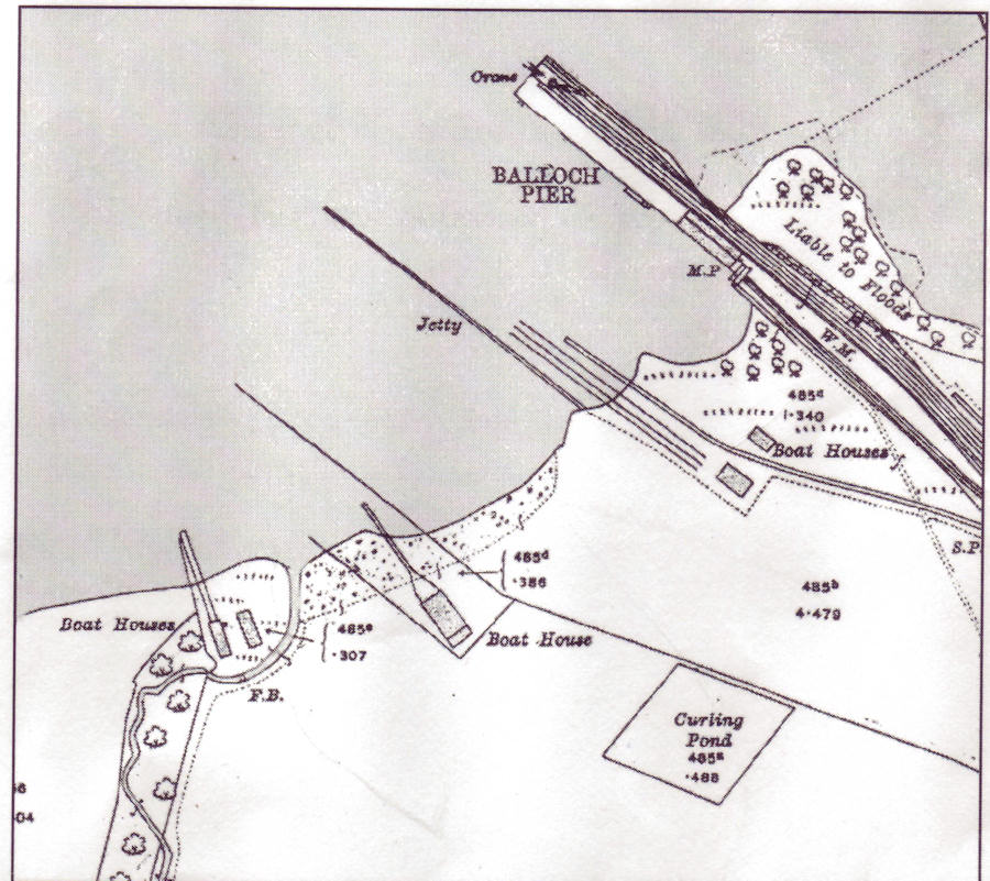 was made to set up a base for the Club on the Loch and James Campbell of Tullichewan provided a piece of ground on the Drumkinnon Bay shore immediately adjacent to the railway company‘s boundary fence. On this site a very attractive 2 storey Clubhouse was erected to a classic Victorian / Edwardian boathouse design.
Access to the Clubhouse, and the adjoining boathouse which belonged to Woodbank House, was via a lane which has long disappeared but the entrance to the lane can still just be seen on Old Luss Road. It is denoted by the short wooden fence which stands between the last former Silk Factory bungalow and the start of the boundary wall to the Cameron Estate on the east side of the road. By the 1930’s this adjoining boathouse and the land around it had become Hogg’s boatyard.
In the early 1900’s the Club also erected a much smaller clubhouse on the east bank of the Leven immediately adjacent to the White Dyke, the southern boundary of Balloch Park. It can be seen in this picture of a right-of-way demonstration from August 1911 at the top of the picture, close to the Dyke. This clubhouse disappeared about the time the photograph was taken, and although Balloch Hotel, whose ground it was, was sold to the Public House Trust shortly after the photo was taken, the Trust had a reputation as pretty benign landlords at Balloch so it’s unlikely that they threw the Club off the land. It seems most likely therefore that 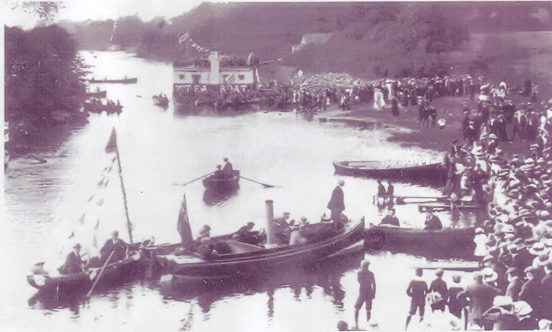 either the Club’s needs changed, or the members quite understandably decided to remove themselves from the scene of weekly public demonstrations.
The Club was very active at Drumkinnon Bay and its members, both men and women, seem to have enjoyed both the sailing and social events. In 1933 the Club acquired a site near to Cashel on the eastern shore of the Loch and moved some of their sailing activities to the new base.
The distinguished Clubhouse seems to have disappeared from Drumkinnon Bay about this time too and there is speculation that at least part of it may have been dismantled and re-erected at Cashel – a number of loch users have commented on the similarity between the old CCC clubhouse at Cashel and the Drumkinnon Bay Clubhouse which appears in old photos.
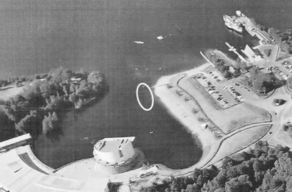
Where the CCC was located relative to to-day’s Drumkinnon Bay.
Thanks to Scottish Enterprise for their permission to use this photograph.
Even although a new Clubhouse had been opened at Cashel in 1933, the Club continued to have a presence at Drumkinnon until the 1950’s – probably for the convenience of members how found it difficult to get to Cashel. However, by the mid 1950’s the Club had vacated Drumkinnon and was operating exclusively from Cashel. Some years after that it changed its name to more accurately describe its activities – it became the Loch Lomond Sailing Club. It describes itself as having “Scottish Inland Sailing at its Finest” and no one can argue with that.
Colquhoun Drive, Rosshead
This road is one half of the circular road around Rosshead - the other half is Halkett Crescent. It dates from the original building of Rosshead in the early 1960's. It could have been named after any of the Colquhouns of Luss, or indeed for the whole clan, but it was named after Sir Iain Colquhoun of Luss, who had been a county councillor and also the Chairman of Vale of Leven District Council until ousted in 1935 by a left-wing coalition, which included George Halkett. Sir Iain seems to have got on well with his political opponents and would probably have enjoyed the irony of being posthumously being joined with George, who was equally easy going.
Cook Road, Balloch
This is one of the oldest roads in the Haldane, having been built about 1953-54. It is named after one of the Vale's GP's, Doctor Cook.
Cordale Avenue, New Cordale Road, Renton
These are the two main north-south thoroughfares in the new Cordale Estate development of the last 15 years, under the aegis of the Cordale Housing Association.
Cordale, Renton
Cordale was the name of an estate, on part of which was built an extensive bleaching and dyeing factory. Also on the estate was a fine house in which the factory owners usually lived, but the factory and the house and its policies were kept very much apart. When the factory closed in the 1940's the council started to build houses on it and by the late 1940's there was an extensive housing estate on the old Cordale estate and part of the factory land, centred on Cordale Square.
This large square, no longer around, was used from the 1940's for political rallies at election times, while in the summer time in the 1950's, the Reverend James Currie of Millburn Church would bring religion to the people and hold popular open air evening services in the Square, using the Communist Party's loud-speaker system. Well it was Renton after all. A few of the old buildings, and some ruins of the factory can still be seen at Cordale Point on the Leven.
Additions were made to Cordale Estate as late as the 1960's, but by then it was obvious that a major regeneration was required. Much of the older housing scheme was demolished or refurbished and for a short time Cordale was renamed Kirkland, after Dr John Kirk, who was the main doctor in Renton for virtually the whole of his working life - from the 1930's to 70's. This well-intentioned initiative was not a great success, and the name Kirkland was quietly dropped.
A new approach was adopted from 1993 onwards, based on the idea of a Housing Association, with the residents managing most of their own affairs. This has developed into the Cordale Housing Association, which is one of great urban regeneration stories in the last 20 years in Britain. It is now, rightly, attracting attention and visitors from around Europe. In the best Renton tradition, much good is being done by stealth.
Cowie Terrace, Alexandria
This is the name given to a terrace of private houses, built in the early 1960's by the house builders Varney, on the part of Gilmour Street west of Smollett Street. It is named after a prominent local family who lived for many years in an adjacent red sandstone villa. One of them was Dr Cowie, who although he did not practice locally, was a prominent member of the medical staff at Glasgow's Southern General Hospital.
Craft or Croft Street, Alexandria
This is the local, and original name for Alexander Street in the middle of Alexandria, for which there is an entry under Alexander Street. It probably started life as Croft Street, named after a croft that was sited there (that is the suggestion when the Parish school moved there from Cameron Estate in 1816). It was further reinforced when it led to the entrance to Croftingea Works, and the “Craft” version is just a corruption of Croft, as it is in references to Croftingea Works as the Craft.
Craig Avenue, Alexandria
This short Avenue in Tullichewan is named after Hugh Craig, an Alexandria Labour Councillor who was first elected to represent Alexandria North on Dunbarton County Council in 1932 and represented it continuously thereafter until his death in the mid-1950’s.
He was at various times Chairman of Vale of Leven District Council and of the Dunbartonshire Police Committee. He was part of the group of councillors of the left from the 1930’s to the 1950’s who dedicated themselves to changing the social conditions in the Vale and was very highly thought of. As has been said of a number of other entries, the length of thoroughfare to which he gives his name is a poor reflection of the size of the contribution he made.
Craigandro Wood, Renton
This wood lies on the west side of the railway line in Renton, more or less opposite the station, and extending up Carman hillside. A number of Renton sports clubs have taken their name from the Wood over the years.
Craigie Fort, Balhama
This is the name given to the hill on the promontory at the end of which Balmaha Pier stands. From it there is a commanding view of the Loch, particularly to most points north, from where any threat was most likely to come. There is no visible sign of a fort actually having been there. However, about 1715 a series of “watches” or local guard companies were formed, from Balmaha to Stirling, to protect the countryside against the raids of the McGregors led by Rob Roy. In some cases they were based in mansions, while in others some form of fortification was erected.
It seems at least plausible that Craigie Fort was one such fortification, probably made of wood, and named after the local watch commander.
Craiglomond Gardens, Balloch
This small private estate was built in the 1980's on a green-field site, which while it lies on the north side of Lomond Road, has its vehicle access from Balloch Road, Balloch. There is no historical connotation to the name.
Craiglynn Gardens, Balloch
This small private housing estate beside the Carrochan Burn and Carrochan Road was built in the late 1980's. It is an amalgamation of two names and has no obvious origin. There is a brief description of the Lynn element under Lynn Walk.
Cranloch Court, Balloch
These flat-roofed 5-storied blocks of flats which stand adjacent to Dumbain Crescent in the Haldane were built in the early 1960’s – a little later than most of the rest of the houses on that part of the Haldane. In January 1968 they bore the brunt of the infamous storm during which the roof of one of them was lifted off by the wind and blew away. Fortunately nobody was seriously injured but the block stood empty for a longish time until thorough-going repairs were carried out. Like nearby Dumbain Crescent, it takes its name from an old local farm – Cranloch, which was on the Horseshoe and marched with the present Lochend Farm. It seems to have been merged with that farm and for about the first half of the 20th century the joint farms were known as Lochend-Cranloch. After WW2 the name Cranloch was dropped from Lochend’s title and only survives in the Haldane.
Crescent, The, Alexandria
This was the name given to the towpath for a few hundred yards southwards from Bonhill Bridge. A number of tenement buildings stood on the Crescent, and they were built from about 1810 onwards. In the 1841 census, the Crescent is called Bonhill Crescent, but by its demise in the 1970's it was known simply as the Crescent. Its best-known building was Bobby Woods' Cosy Corner Bar and Lounge, which stood on the corner of the Crescent and Bridge Square.
The housing, which has replaced it on the Riverside Estate, is a significant 10 yards or so further away from the Leven, and also the banks were raised a few feet when the new houses were built in the 1970's. These measure were meant to combat the fairly frequent flooding to which the Crescent was prone, and worked pretty well until December 2006 when the Leven reached heights unprecedented in living memory. Even then, sandbags helped prevent more serious flooding.
Creveul Court, Alexandria
Built as part of the Town Centre redevelopment in the 1960’s, it is named after Charlie Creveul, who represented Alexandria East on the Vale District and then County Council for Labour, with a break 1955-58, from 1945 until January 1961 when he abruptly departed from the Vale in very sad personal circumstances after the sudden deaths of his daughter aged 21 then his wife and an aunt, all in a short space of time the year before. He was Chairman of the Vale of Leven District Council when he left, as well as being prominent in the Co-Operative movement. He ended up living in Lancashire where he eventually resumed his involvement in the Labour Party, rubbing shoulders with the likes of Prime Minister Harold Wilson, who was a Merseyside MP.
Croft Street or Loan, Bonhill
One of the earlier streets of Bonhill as it expanded up the Brae. The name comes from a croft on whose land the Street was built. Its most famous resident was that great Vale institution, McDougall's Lemonade factory. McDougall's Ladyton Springs lemonade was made in Croft Loan for over 100 years, from the early 1880's to the 1990's when Alex McDougall sold the business to a competitor. The factory was closed, the land sold and houses built on it.
As in Croft/Craft Street in Alexandria Croft Loan was commonly known as Craft Loan locally.
Croftamie
While many of the estates, farms and houses in and around the present-day village of Croftamie go back hundreds of years, the name of the village itself goes back no further than about the 1850's. When the Balloch - Stirling railway line reached it in 1857, they called the halt Drymen Station rather than Croftamie. Even as late as 1884, the Ordnance Gazetteer of Scotland, although referring to Drymen Station, makes no mention of Croftamie. In fact, the earliest written reference to Croftamie is 1823, and that referred only to a general area - there was not a village at the time.
In spite of its recent origin, there is no authoritative definition of the name Croftamie. The Croft is a croft, but whether that is significant or not, we don't know. Similarly, what the derivation of the “amie” part might be is unknown. There is also a Croftamie entry in the Loch Villages pages.
Croftengea Works, the Craft or Croft, Alexandria, Official name Alexandria Works
These are three of the many names, which were given over about a century and a half to what was the largest and last of the UTR textile works in the Vale. The northernmost part of the works was originally known as Levenfield Printworks, and this was also the oldest part, opening originally as a Printfield in 1768, making it the oldest textile works in Alexandria. It was also the first printworks, as opposed to bleachfield, in the Vale.
The southernmost part, around where the Craft Gate still stands, was the original Croftengea Works, started in 1790 by William Stirling & Sons of Cordale and Dalquhurn. The middle part of the works had been the Charleston Engraving Works where the pattern plates for printing etc were engraved. The Croft and Levenfield were merged in 1860, but Charleston did not become part of the organisation until the formation of the UTR in 1897.
The heyday of the works was from the 1850's and 60's onwards, when most of the substantial brick buildings were built. It was reasonably busy until the 1950's by which time volume work at all the other UTR works had finished and most had long since closed (a small specialist UTR operation remained at Dalquhurn until the mid 1960's). The Craft was taken over by the Calico Printers Association and closed in 1960.
The Craft stock - its main chimney - was reputed to be the highest factory chimney in Scotland. It was visible for miles around and was a very useful navigational aid on Loch Lomond. Over 300 feet tall and weighing over 2,500 tons it was demolished in 1964 to make way for the building of Loch Lomond Distillery.
A surprisingly large number of the buildings from the 1850's have survived more or less intact, and are now used as whisky bonded stores, and by the Antartex Village retail complex. The boundary wall with the Leven towpath has been allowed to fall into disrepair, particularly from the Heather Avenue to the Ferry Steps, and there is thus little to act as a flood barrier when the Leven rises to the abnormal heights seen in the last few years.
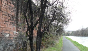
Trees and Wall blackened by the "Angel's Share"
The image above is of some trees on the opposite side of the wall from the Loch Lomond Distillery's whisky bonded warehouse on the river Leven towpath. The whisky is stored in oak barrels which allow some of their contents to escape through the wood. Typically 2% to 5% of the contents of each barrel is lost each year (one reason for the higher price of older whiskies). This loss is known as the "angel's share". When it enters the atmosphere surfaces and trees adjacent to the bond get covered by a mould, which turns them black although the trees are still quite healthy.
Cross Keys, The
This is the road junction, now a roundabout, where the road through Glen Fruin to the north and the road from Muirlands to the east meet the Black Hill road from Arden to Helensburgh. There was once a toll at this spot and the old house at the junction was the tollhouse.
Cross Street, Alexandria
This Street appears in a map of the centre of Alexandria in 1864 but has gone by the time that the first Valuation Roll appeared just over 20 years later. However, the line of the road still pretty well exists, since it was more or less exactly where Lennox Street now is, and ran from Craft / Alexander Street to the bottom of Wilson Street.
Cullen Street, Alexandria
This short street in Tullichewan, like a number of others in Tullichewan, is named after a local doctor. In the case of the Cullens, there were three generations of doctors who served the people of the Vale from about the 1850's to the 1920's. One of them was killed in a railway accident at Dalreoch Junction in 1889, while another was one of the first people in the Vale to have a motorcar. The Street belongs to the second phase of building of Tullichewan i.e. the 1960's.
![]()