Place Names (M) Main Street, Renton - Muirlands
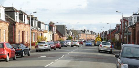
Main Street, Renton, now the B857
Being part of the Dumbarton - Inverary military road that was built in the 1740's, it was handily in place to be used as the Main Street when Renton was founded in 1762. It was the through road and well built for the time, so it was unquestionably the Main Street, and formed the backbone of the village from the outset. Luckily we have a view of the first days of Main Street Renton, in an engraving of about 1777 of the Smollett Monument. This is in fact the first pictorial representation there is of anywhere in the Vale of Leven.
 The Tobias Smollett Monument
was erected in Main Street in 1774, on the site it still occupies, and
it was the first significant event in the development of Renton. The
engraving centred on the monument looking south, and shows nothing to
the north of it, but it does show the very clear straight line of Main
Street going to-wards Dumbarton, and a few cottages on either side of
it. The monument centred the village very well at the time, and was indeed
close to the central core of houses until the 1930's.
The Tobias Smollett Monument
was erected in Main Street in 1774, on the site it still occupies, and
it was the first significant event in the development of Renton. The
engraving centred on the monument looking south, and shows nothing to
the north of it, but it does show the very clear straight line of Main
Street going to-wards Dumbarton, and a few cottages on either side of
it. The monument centred the village very well at the time, and was indeed
close to the central core of houses until the 1930's.
Main Street was one of the first streets to be named and covered that part of the road running from what became Hall Street in the south, to Cardross Road in the north. Main Street and Back Street ran parallel to each other, and a number of shorter streets crossed it from the Leven to Back Street to form the core of Renton. The name Main Street also defines the original north - south length of Renton - Lennox Street was only created in the early 1880's as new public and tenement red sandstone buildings were added at the south end of the village. While to the north, even in the 1880's, Millburn Church, which had been completed in 1845 as a Free Church, and the more recently built houses on Main Street north of Cardross Road, were regarded as a separate district lying just outside the village.
This attitude continued until the end of the century with some people in Renton. Not only could no land be found within Renton for the dissenting Millburn Church in 1845, but also nearly 50 years later in 1889 Saint Martin's Church had to go even further north on Main Street than Millburn Church. It is said that the main landowners of the time would not sell land “in the village” to either of these non-establishment churches at the time of their building - although other free churches were built in Renton at other times. The land for both was provided by more liberal-minded, not to say Christian, men, Campbell of Tullichewan, and Turnbull of Place of Bonhill respectively.
Growth of the village was swift - by 1788 the first Masonic Lodge in the Vale was founded in a house above the Black Bull Public House, which was in Main Street. It may not have been the same Black Bull as stood until the early 1960's at the corner of Station Street, but the information tells us a lot. Firstly, there was at least one two-storey house on Main Street by 1788. Secondly, there was already a public house in the village, and thirdly the name “Black Bull” denotes that cattle drives came through Renton even then, long before the Cattle Fair moved onto Carman Hill for much of the 19th century, since the name was a sort of “drovers union” sign, not unlike the CIU signs on workingmen's clubs to-day. Fourthly, of course, it showed that Renton men were already organising themselves into clubs.
In spite of the two-storey Black Bull house, most of the original buildings on Main Street were single-storey rows of houses with one or two rooms. This was the most common type of house in Renton in the early days, and some survived until the late 1950's, although most lasted only until about the 1850's.
About then a steady stream of privately funded building replacement began, not just with houses, but also with businesses such as shops, banks, public houses, tearooms etc. Most of this centred on Main Street. An indication of this is that the two oldest surviving houses in Renton at the present, date from about 1868, and both are on the east side of Main Street, almost opposite the School.
Further evidence is that the largest school in Renton was opened on Main Street in 1858, replacing a number of earlier ones. It was considerably expanded in 1875, to give it the two-storey, bright looking aspect, which it had for about the next hundred years as Renton Public School. The present Primary School and Language Unit were built on adjacent property in 1975, although the old school was not demolished until 1982. Most of the old school playground continues in service as the new school playground.
In 1870, the Church of Scotland mission to Renton was upgraded into a full-scale Parish, and the building on Main Street became a Parish Church. Although this building stood until the 1980's, it only lasted as the Parish Church until 1892 when the new Trinity Church opened round the corner in Alexander Street.
Renton Football Club was founded just a few months after the Vale in 1872. It used a few fields at the north and then the south end of Renton, before settling into Tontine Park just beyond the south end of Main Street in 1878. It was here that Renton FC enjoyed their greatest triumphs, winning the Scottish Cup in 1885 and 1888, and of course becoming football's first World Champions by defeating West Bromwich Albion 4-1 on 19th May 1888.
By the 1880's, Main Street was a bustling, busy housing and commercial thoroughfare, where the preponderance of new plate-glass frontages to the shops, then something of an innovation, drew very favourable comments. There were about 70 - 80 businesses then operating on, or just off, Main Street. They included two bank branches - The British Linen (from the 1960's part of the Bank of Scotland), and Clydesdale Banks - and their presence was indicative of Renton's prosperity at that time.
Many fine new buildings were added to Main Street as a result of this prosperity. In 1883 Renton Public Hall was opened at the corner of the appropriately named Hall Street. It went through a variety of names and uses, gaining its first film licence in 1912, changing its role and name to the Picture House in 1918, and the Roxy in later years, and ending its days as the Burroughs Social club, before a fire and demolition.
In 1887, the year of her Golden Jubilee, the Victoria Institute was opened. It survived in Public use until 2006, when it was sold off by West Dunbartonshire's then Labour Council. 1891 saw the Argyll Public House tenement (later the Kind Man and then Toby Jug) and the Central Bar building followed it in 1893. Both of these buildings still stand.
Perhaps the finest of them all was Govan Place on the east side of the Street, which was built for Peter Ewing the dairyman, in 1896. It later also housed Templeton's the grocers. One unusual feature of some of the houses built on the east side of Main Street from about 1830 onwards, is that because of the embankment which sloped to-wards the towpath and the Leven, one or even two storeys were built below the level of Main Street, into the embankment, with doors and windows which only faced east over the river.
Many of the houses in these buildings continued to be occupied until the 1940's while many of businesses only closed in the 1960's. As Renton expanded southwards in the 1880's, the part of Main Street to the south of Hall Street was renamed Lennox Street. Presumably this was a marketing ploy on behalf of the builders of the day who wanted to demark their fine new red sandstone public and private buildings from the older part of town.
In 1897 the south end of Main Street lost one of its great attractions when Renton FC went bankrupt, and dropped out of the Scottish League. Tontine Park continued in occasional use for such things as galas and Highland Games, but the Wylie Park, just across the road, soon became available as a site for these events.
For 20 years, from 1908 - 1928, tramlines ran down the middle of Main Street as part of the Balloch to Dalmuir tramway system. It was a single-track line with a passing place outside the school. By 1900 the northern boundary of Main Street and Renton was regarded as the Mill Burn - that had always been the Cardross Parish boundary since its creation in the middle ages.
On the eastern side of Main Street at that end of town, behind a high brick wall that ran all the way from the Mill Burn to Stirling Street was Cordale Estate. The Estate dated back to the 17th century, and on its stood Cordale House, which was built about 1770. For over 100 years the owner / main director of Dalquhurn and Cordale Works lived in this very attractive mansion. The last resident was Alexander Wylie, MP for Dunbartonshire 1895 - 1906, and a sort of unofficial provost of Renton. The entrance to the Estate and Cordale House was opposite the Bowling Green Tavern.
In 1922 Renton's War Memorial was unveiled at Howgate, beyond both Main Street and Lennox Street, and all of the houses at the southern end of Renton. That was about to change, because the County Council had acquired Tontine Park and started to build houses on it. The first houses were occupied about 1928, mainly with people moving from overcrowded housing in Back Street. At the same time at the north end of Main Street, the Red Row had been opened up to give access from Main Street to the new Hillfoot houses at the northern end of Back Street.
By the early 1930's the Council had also acquired the Cordale Estate and demolished Cordale House to make way for the new Cordale Housing Estate. During the 1930's, the southernmost of the new houses being built on Cordale Estate appeared on Main Street at Stirling Street, and over the next 15 years or so gradually extended northwards, as the old estate wall was knocked down and the new tenements built. After a major refurbishment about 20 years ago, they still stand on Main Street.
Its hard to believe now, but as recently as the 1940's there were about 60 shops and pubs on Main Street, down from the 77 of the period 1925 - 30 listed in Jim Murphy's book, but just a wee bit more than the current figure of 7. It isn't just the number of shops that impresses, it's the diversity of them. Grocers, confectioners, bakers and butchers are all expected. But a milliners? It's actually a great insight into the way that people lived, and also how little a shopkeeper could get by on in those days.
The shops, and most of the old Main Street, were demolished in the early 1960's to make way for the first iteration of Renton redevelopment. This featured a wide open aspect on most of the east side of central Main Street, with an unbroken view over the Leven, but also many new houses and a new shopping centre on both sides of the Main Street just north of the Cross. Some of these shops did well for a number of years - e.g. people came from all over the Vale to shop at Alex Rennie's butcher's shop - and the general stores obviously met the requirements of their customers. However, economic and social problems were obvious, and it proved very hard to maintain standards.
There was no lack of effort from the authorities - one 1960's five-storey tenement block on Main Street, and its immediate surroundings, were refurbished at a rumoured cost of £1 million in the 1980's. After a few years, defeat was admitted and they were all demolished.
Although it was not apparent at the time, things were about to get markedly better for Renton, and eventually for Main Street. Cordale Housing Association (“CHA”) was founded in 1993. It has spread benefits around Renton, not least taking the lead in developments on the Main Street, such as the new medical centre and chemists on the site of the old shopping centre on the east side of Main Street, the new Spar shop on the west side, and the very sheltered accommodation on the south corner of Burns Street and Main Street which is the biggest single building investment in Renton in decades and will by June 2008, provide up to 40 sheltered apartments at the heart of the community.
The businesses and buildings, which have shown some relative longevity, deserve a mention. The oldest building is Tobias Smollett Monument, then the school (in spite of two attempts to close it in the last 25 years). The Central Bar, now Renton's and Main Street's only public house, where once there were seven, and the building originally built as the Argyll Bar both of which date from about 1891. The former Bowling Green Tavern or Lizzie Connolly's pub is also from about that time. It lay fire damaged and empty for many years, but now (2008) it has been redeveloped as very attractive terraced houses. Last but by no means least, Tom Swan, whose confectioner's shop, now beside Red Row, is a long standing Renton and Main Street institution, and apart from the McLaughlins Farm, by far Renton's longest running family business.
Manse Drive, Balloch
This road in the Haldane, built about 1954 was named after the Jamestown Parish Church Manse, which stood more or less at the end of Manse Drive in the junction between Cooke and Miller Roads. The minister moved to another manse in Balloch, before the building of Mill of Haldane started.
Margaret Drive, Alexandria
This is an extension to Gilmour Street, which runs along the top of the Ritchie Hill parallel to the bypass. The houses on it were built in the 1970's and 80's, but there is no record of who Margaret was.
Martin Avenue, Haldane, Balloch.
This short road, dating from the late 1950’s, is named after the first Labour MP for the area, William Henry Porteous Martin. When he was elected in the 1923 General Election, the Vale was part of the old Dunbartonshire constituency. He was defeated in the next year’s General Election in 1924 and disappeared from sight as far as the Vale is concerned.
Matheson Lane, Jamestown
This short thoroughfare dates from the 1960's, and is named after the Vale evangelist of the earlier part of the 20th century, who founded Mathieson's Mission, a Christian group based in Susannah Street. The spelling of the name of the Mission, as usually rendered (see below) and the Lane are different. A road nearby is named after another Christian lay preacher, Gavin Grainger.
Mathieson's Mission, Alexandria
Mathieson was an Alexandria man who founded an evangelical Christian movement in the Vale in the early part of the 20th century. He attracted many adherents and they built their own meeting place in Susannah Street. When the Mission closed, the Hall was acquired by another religious group, who had been based in Mitchell Street, and the Mission Hall was renamed the Ebenezer Hall. It is still in use.
McAllister Road, Alexandria
This Road is almost, but not quite, unique - a street in the Vale named after an Independent councillor in the 1960's or 70's. This town centre street, which was built as part of the town centre redevelopment, is named after a councillor who represented the centre of the Vale in the 1950's and 60's as an Independent. There were still a couple of them about in Alexandria (and Luss and Gartocharn) up until local government reorganisation in 1974, which meant bigger wards, and that favoured Labour in most of the Vale.
McColl Avenue, Alexandria
This road in Tullichewan was built when conventional houses were replacing the aluminiums in the 1960's. It is one of the streets in which an element of ambiguity remains, because it could have been named after a BPC councillor of the 1920’s, a long-serving District Councillor of the 1930’s to 1950’s or Ian McColl the footballer. Unlike McGregor Walk, which is nearby, there was no public announcement when it was named in the mid 1960’s so all 3 are possibilities of varying likelihood.
If it is named after Ian McColl, then it is the only street in the Cradle of Scottish football (always excepting Renton) named after a football player, which is a great omission. Alexandria born Ian McColl played for, and captained, Rangers and in a career spanning the years 1945 - 60 at Ibrox he also captained Scotland at the World Cup in Sweden. After hanging up his boots he moved into management, firstly with Scotland, 1961 - 65, who won 16 out of the 27 games with him as manager, including the 2-1 win over England at Wembley in 1963, and then with Sunderland. Fuller details of his career can be found here.
The main other possibility is William McColl who represented Alexandria North for Labour on the District Council from 1930 until 1952.
Edit: Margaret Costello later confirmed that McColl Avenue was definitely called after her Grandfather William McColl who served for 25 years as a Councillor.
McCulloch Lane, Alexandria
This lane in Tullichewan, which was built in the 1960's on land previously occupied by the aluminiums, is named after Hector McCulloch, Labour County Councillor in Alexandria from the 1930's to the 60's. He was an influential figure, who was the de facto leader of the Labour Party in the Vale in the late 1950's - 60's.
McGinns, Bonhill
McGinns was the name used by locals to refer to the old quarry at Bonhill. Presumably McGinn was the quarry operator?
McFarlane Road, Haldane
This Road in the Haldane was something of a puzzle for a while, because no-one called McFarlane was elected to the local Councils in the 1920’s and 30’s, which is when most of the councillors commemorated in Haldane road / street names served on either the County or Bonhill Parish Council. However, Angus McFarlane was co-opted onto the best-remembered of the Bonhill Parish Councils, that of 1922-25. He was already politically active in the Vale having led delegations to the Parish Council in 1920-21 seeking an increase in Poor Relief and he stood as a Labour candidate in the 1922 election for the Alexandria East seat.
He was 4th in a seat which elected 3 councillors. Peter Talbot (after whom Talbot Road is named) topped the poll in Alexandria East, but resigned from both the Chairmanship of the Parish Council and also from the Council itself about 6 weeks into the 1922-25 term and Angus Robertson was co-opted in February 1923 to take his place. However, that’s not the end of the story because he did not serve out the term, resigning in August 1924 i.e. after having served for only 18 months; no reason was given.
McGregor Avenue, Haldane
This thoroughfare in the heart of the Haldane, dating from the mid 1950's, is named after Reverend Dr McGregor, the minister of Jamestown Parish Church who had died a few years previously.
McInnes Steet, Haldane
McInnes Street, which links Miller Road and Cook Road in the Haldane, was named after local councillor Thomas Fry McInnes, who was born on 4th January 1884 and died in January 1944. His very strong background in the Friendly Society movement meant that he understood all the poor relief and health insurance issues which came to dominate local politics immediately before and after WW1.
Initially a member of the Vale Liberal Association he was endorsed by the Vale Trades Council and Wards Committee when he stood for Bonhill Parish Council’s Millburn Ward in 1919. He was unsuccessful but when he stood again in 1922 he was elected in Millburn. Thus he was a member of the Labour group on the Bonhill Parish Council of 1922-25 which has earned its place as a footnote in Scottish history books for taking on the Conservative government of the day on the subject of poor relief.
It was a constant battle on the Parish Council and it took its toll on many of the Labour councillors, who either resigned from the Council during their term or never stood again for public office. Thomas McInnes was one of those who resigned – in March 1924 after 16 months on the Council. He never stood for the Council again.
McIntyre Terrace, Balloch
This short terrace on Dalvait Road in Balloch, built at the same time as the rest of the Dalvait Estate in the early 1970’s, is named after Hughie McIntyre, Communist County Councillor in Bonhill for over 20 years until he was defeated in 1952. In December 1935 he ousted Sir Iain Colquhoun from the chairmanship of the Vale of Leven District Council after the local elections that month in which the left-wing parties had taken a commanding majority. He was one of the leading figures in improving housing and education in the Vale at that time. As has been remarked upon elsewhere, it’s sometimes ironic in the Vale that those who have made the greatest contribution to the common good have the shortest stretches named after them.
McKim Walk, Renton
This short stretch of houses runs off the east side of Main Street in the south of Renton and is named after David McKim, a Renton Councillor from the 1930's. He was part of a well-known Renton family of photographers and political activists who had shops in Renton and Alexandria. His brother Willie was perhaps the better photographer and many of his colour photos, particularly of the Ben and different parts of the Loch, taken in the 1930's, have never been bettered and remain the Loch's iconic images.
McKinlay Avenue, Balloch
This short Avenue in the Haldane was built in the mid 1950's and is named after Adam McKinlay who was the Labour MP for West Dunbartonshire from a by-election in 1941 to 1950. He died a few weeks after the 1950 election, but Tom Steele held the seat for Labour in the resulting by-election.
McLean Court, Balloch
This short street in Balloch is named after Cathie McLean who was the Labour County Councillor for Balloch and the Haldane from the 1950's until the early 1970's, and Chairman of Vale of Leven District Council in the 1960's.
McLellan's Brae better known as Bauchop's Brae, Alexandria
This was the farm track, which led up to Millburn Farm. It must initially have run from Main Street Alexandria, but after Burnbrae was built it ran from Queen's Drive. Both McLellan and Bauchop were farmers at Millburn over the years and the Brae's name changed with the different occupants of the farm. In fact, it is still called Bauchop's Farm by some people in spite of it not being a working farm since the last farmer, Jock Graham, retired in the early 1970's.
Some people also still call it Graham's Farm. The building of the Alexandria bypass in the 1970's closed vehicle access to the farm from Burnbrae. There is a pedestrian tunnel under the A82, which gives access to the brae. The Brae carries on past the old farm, as a sort of sunken track between two hedges, up onto Carman hill, and looks pretty well as it must have done in its old role as a drove road.
Note: We were contacted by Catherine Cameron, who has historical family connecttions to the farm. She recalls that this was actually called "McLaren's Brae". Catherine informs us that the farm was tenanted by someone called McLaren in the late 19th century so it is perfectly possibly that McLellan is wrong. Some local people pronounce McLaren as "McLeran" so it may have beeen corrupted over the years.
McNaught Place, Renton
This short row of houses, adjacent to Renton Bowling Club, was named after Mrs R McNaught who was a County Councillor in Renton immediately after WW2, being elected in December 1945. Mrs McNaught had an almost unique place in Britain’s wartime political history. She would have been a Councillor 3 years before that, but for an unsavoury piece of chicanery on the part of the so-called Independents on the County Council in February 1942. There was a war-time agreement, issued by the coalition government, that local council elections and by-elections would be suspended for the duration. Councillors would continue in post and when a seat fell vacant through death or resignation, then the person nominated by whichever party presently held it would be declared elected. That agreement was honoured all over Britain – except in Renton.
When the Labour seat of Renton East fell vacant, Labour nominated Mrs McNaught fully expecting her to be declared elected. The Independents / Moderates, who were closet Tories to a man and woman at local level but supported the Tory candidates in national elections, ignored this nomination and appointed Lt – Col Findlay VC, a member of the Boturich family, but who had stayed in Helensburgh for many years, as the Councillor for Renton East. The anger felt at this was compounded by the fact that they had a majority because some councillors on the left were serving in the forces and couldn’t vote for Mrs McNaught – the Communist councillor for the other Renton County Council seat, Renton West, being a case in point.
The matter was raised at government level but the Scottish Secretary said the agreement was a voluntary one and while he and the rest of the government deplored what had happened, he couldn’t do anything about it. At the first opportunity to ask the good people of Renton what they thought of Lt Col Findlay, in the elections of December 1945, he scurried back to Helensburgh to contest the Colgrain seat, never to be seen in Renton again. Mrs McNaught easily won the seat that should have been hers three and a half years earlier, but it took Renton many years to get over that particular piece of political skulduggery.
McPherson Lane, Alexandria
This lane in Tullichewan, built in the 1960's, is named after Alistair McPherson who was from the 1930's to about 1960 in charge of the Parks Department for the old Vale District Council. On taking up his new job in the 1930's, his first big challenge was to convert the Lyddite munitions works with its bunkers and pits, which looked like the surface of the moon, into the Argyll Park.
From the outset, the main football pitches in the Argyll Park were regarded as amongst the very best playing surfaces in Scotland, and an excellent cricket wicket could be fitted in between them as well. It is a mark of the quality of the job that he did, and its visual and recreational impact on the Vale, as well as the high regard and affection in which he was held, that an employee of the council was recognised in this way.
Middleton Farm, Alexandria
This farm, which stood about half way up what is now Overton Street, went back centuries - it appeared on Roy's Map of about 1750, and was spelled Middletown on that map. It is referred to in other documents as Middletoun. Of course, at the time of these early references there was no town of Alexandria for it to be at the middle of. However, there were a number of other farms on the west side of the Leven, which collectively might have been referred to as a farming township.
By the 1870's when it started to disappear under buildings in the development of west central Alexandria, it was owned by Wattie Gardner. The road up to it was known as Wattie's Loan (it is now called Overton Road, after the Farm above the Vale where it terminates). By the 1890's the farm had completely disappeared under the villas on Overton Road.
Middleton Street, Alexandria
The growth in demand for housing of all types in the late 1850's and 1860's, led to much land throughout the vale being “feud” i.e. divided into building lots on which a separate feu duty would be paid. One of the first of these developments to get under way was Middleton Street in Alexandria. It ran parallel to Main Street from what was then Notman's Field (now the Christie Park) to what became, at about the same time as Middleton Street extended that far, Upper Bridge Street.
The little changed Middleton street Alexandria
Like other streets from about this period, or immediately before it, it was not built in a serial, uniform fashion, but buildings were erected as and when builders acquired the land, funds or both. It is also very noticeable that the type of house being built changes from north to south, and the change takes place at Overtoun Street / Road. To the north of that are detached or semi-detached cottages, which were built to accommodate the growing middle class of managers and professional people.
Middleton Street is the first street in the Vale in which this happened. South of Overtoun Road are a number of red sandstone two storey terraced housing, both taller and to a higher internal specification than the houses of 40 years or so before, in Main Street. The second terrace from Overtoun Road on the east side of the street is dated 1879, while a more southerly one is dated 1873, so they were not all built at the same time and indeed there must have been gap sites for a number of years.
These houses were built for foremen and journeymen, the sort of key workers of the day. Unlike many of the terraces in Bonhill and Jamestown, which were built by a factory owner, it was private individuals or the new-ish Vale of Leven Building Society that built them. The name of “Middleton”, while geographically very apt, was chosen because the street was built on what had been up until then, Middleton Farm, which belonged to Wattie Gardener or Gardiner.
Mill of Balloch, Jamestown
The Mill of Balloch was in Jamestown, and was entered by a lane at the top of Dalvait Road. There was also access through a gate at the bridge over the Carrochan Burn in Dalvait Road. It was a grain mill, powered by a large water-driven wheel, which dated from the late 18th century. The water to drive it originally came from the Dam of Balloch,
After flooding destroyed this dam, Jamestown Dam replaced it about the middle of the 19th century. The mill was in use until the 1920's, but new technology including steam-driven traction engines, which went out to farms, replaced it. The mill wheel was occasionally turned right up until the mid 1950's, but not in anger. Some of the buildings associated with the mill also continued in use until the 1950's. Itinerant “tattie howkers”, some Irish and some Scottish, used to lodge each autumn in the old stable building, at the entrance to the Mill. Kessog Gardens now stands on the former site of the Mill.
Mill of Haldane Housing Estate
This is the largest of the immediate post World War Two's housing estates in the Vale, consuming as it did the whole of Milton Farm's 119 acres in one fell swoop. The totality of the hillside estates in southeast Bonhill is larger than the Haldane, but individually each estate is smaller.
At the time, the Haldane was seen as being relatively remote, and care was taken to build some supporting infrastructure at the same time as the houses. Thus a new primary school, Haldane Primary opened about 1956, and a number of shops - a Co-Op grocery, chemist and post office, and newsagents also opened about that time. A bus route, the 137, was even immediately created to slot into the Balloch-Glasgow route. Lessons had been learned from other new housing estates.
The houses were built for two separate landlords. Firstly, Dunbartonshire County Council, which was addressing local housing needs in the Vale. Secondly The Scottish Special Housing Association, whose main role was to provide housing in support of the government's economic strategy. In the Haldane this meant Greenock's Torpedo Factory workers being transferred to the Vale because of the closure of the Greenock factory.
This was probably the biggest influx of new people over a short period of time that the Vale had experienced up until that time, and it was a bit like a communal blood transfusion. The people from Greenock and Gourock brought many new ideas and gave fresh impetus and enthusiasm to many clubs and organisations in the Vale - in particular to Jamestown Parish Church. Some returned over the Clyde when the Torpedo Factory shut, but most stayed on, now firmly Vale folk.
There had been plans since the 1930's to have a new housing scheme stretching from Bonhill to what is now the Haldane, to replace the old houses in Bonhill, the centre of Alexandria, and the centre of Renton. By the time it came to implementing this plan, it had been changed to two separate estates - Dalmonach (which started in the late 1940's) and the Mill of Haldane scheme, modified because of SSHA's participation.
Actual building work started about 1953, with the first houses occupied in late 1953 and early 1954. Building started from the most accessible points, on the west side of the scheme, and worked steadily east. The first roads completed, therefore, were at the west side of the estate - Shandon Crescent and Shandon Brae, and parts of Miller Road and Dumbain Road. The work then proceeded quite steadily eastwards over a period of two years or so and finished on the west side of Dumbain Road. Woodburn Avenue, Davidson Road and the 5 storey flat-roof flats were all added later in the 1950's and early 1960's.
Parts of the Haldane were badly damaged in the storm of 1968 - including a roof being blown off a 5 storey flat. By the late 1990's some of the Haldane was in need of freshening up, and this has been going on for the last 6 years or so, particularly in the eastern part of the estate. Many buildings have been demolished, particularly flats and terraced buildings, to be replaced by 2-storey semi-detached houses. Although this work has inevitably resulted in parts of the Haldane resembling a building site again, the results so far are very impressive.
Mill of Haldane, Balloch
This was originally a clachan, which took its name from the Haldanes of Gleneagles who inherited most of the land immediately to the north of Balloch in the Partition of the Earldom of the Lennox in 1493.
There would have been a mill there for the grinding of grain etc from Haldane's farms, and that is how the name came into being. Its location was / is where the road west down to Balloch Ferry connects with the Dumbarton - Stirling road. Although mills surrounded that whole area, there's no evidence left to-day of the mill. However, there was until the 1950's, a blacksmiths, operated by Donald Aitken, the third generation of Aitken's to be a blacksmith there, who was also the local county councillor for many years until the 1950's.
The smiddy, altered a bit, but still recognisable, still stands, including a building over the Ballagan Burn, as does what was originally a croft and then a dairy, which lies behind Haldane Terrace. Both of these go back more than 200 years. Until the 1960's there were tenement buildings from about the 1850's on the other side of the Stirling Road between it and Mollanbowie Road, on what is now a grassy space.
If Haldane Terrace looks like other terraces built by Sir Archibald Orr Ewing, that's because it was - about 1880. Until about 1900 and the start of villa building in Drymen Road, the Mill of Haldane would not have been thought of as part of Balloch, but as being a self-contained rural community on its own.
Millarochy Bay
One of the Loch’s best known beaches is at Millarochy Bay on the eastern shore about 2 miles north of Balmaha on the Rowardennan road. Like most of the Lochside names it derives from Gaelic – in this case “meal larachain” meaning the hill or knoll with the little ruined farm. These days there’s very little ruined anything at Millarochy except the summertime peace and quiet of a beautiful setting as day-trippers descend on the beach by all means of transport, unfortunately including jet-skis, for which it seems to have become the base.
Millburn Depot / Millburn Pyroligneous Works
From about the 1920's onwards, the Millburn Depot, which straddles the Alexandria - Renton boundary has been the Council's road department depot. Latterly, like just about everything else in the Vale, West Dunbartonshire Council decided that they didn't need it and it was used by Argyll & Bute Council until they could build one of their own in the Helensburgh area. In the last few months they have announced that this is now in hand and they intend to dispose of the Depot. The land will be redeveloped for housing.
That could yet prove interesting, because one of the benefits of its use as a Roads Depot was that while polluting agents such as tar and salt were stored in the Depot in fairly liberal quantities, that didn't matter too much since the land was already polluted from its time as the Millburn Pyroligneous Works (1790 –1900). This was a chemical works, owned by the Turnbulls of Place of Bonhill, which extracted chemicals from wood for use in the dyeing process in the Vale textile works.
Millburn Farm, Alexandria
Although it ceased to be a farm about 1970 and is now a private house, this farm just above Burnbrae was one of the oldest in the Vale. It appears on maps from the late 18th century and no doubt it existed before that. It was accessed from the track up Carman from Queen's Drive, a branch of which went into the back or south gate of the Vale Cemetery - the route by which hearses usually exited the cemetery after a funeral. This route was cut off by the Vale bypass in the mid-1970's. The bypass goes within yards of the farmhouse and a new road along the cemetery's eastern boundary was built, but by then Millburn was no longer a working farm. Jock Graham was the last farmer there.
Millburn Park, Alexandria
The home of Vale of Leven FC and their descendants, the Vale of Leven Juniors. Millburn is actually the third home of the Vale. Cameron's Park on the Doctor's Loan was the first short-lived home, opened on 11th January 1873 by a game against Queen's Park. The next ground was North Street Park at the corner of North Street and Lennox Street, home to the Vale from 1873 until April 1888. North Street Park was the Park in which the Vale had its cup glory years from 1877 - 79, and on which the “Old Vale” team played.
Hastened by a 5-0 defeat to Renton in the last game at North Street, the Vale started building Millburn in May 1888, and played their first game there on Saturday 18th August 1888 - against Dumbarton, and it ended in a 2-2 draw. Contrast the building speeds and costs of 1888 till now. Construction of Millburn began on 25th May 1888.on a 12-acre site - 5 acres were allocated to football - on the same plan as Hampden. This meant a park 120 yards long by 75 yards wide, with a surrounding quarter mile cinder track 15 feet, with final stretch on the eastern side of 20 feet width.
The preparation and laying out of the pitch and track cost £442. The pitch and turf contractor was a Thomas Kinloch of Alexandria - perhaps of Napierston Farm since the turf seems to have been sourced locally. The surrounding fence was from the outset made of corrugated iron sheets (“like Ibrox” as was noted at the time) and this together with moving the grandstand and pavilion from the North Street Park brought the total cost to about £700. It was ready for the first game on 25th August 1888 - just under three months from the start of the work. The Victorians certainly outshone us in their building projects.
Millburn was the name of the whole area, including the football ground (see the Millburn entry) and it all belonged to Mr Turnbull of Place of Bonhill and the Millburn Pyroligneous Works. He rented the football ground to the club on a very advantageous 20-year lease. The ground was declared open by Mr Gilmour, of the Gilmour Institute etc fame, who then went out to the centre spot and set the game in motion by kicking the ball up into the air. The layout hasn't changed much over the years - the pitch not at all. A new brick bungalow type pavilion was built and lasted for many years until destroyed by arson, as was the fate of a large wooden shed, which housed the Vale of Leven Harriers who shared Millburn with the Vale until the 1970's.
A new Fort Apache-type clubhouse now houses changing and committee rooms etc, but vandalism has recently damaged the turnstile area. The hay sheds from both Ladyton and Nobleston farms were re-assembled at Millburn when these farms were built on, giving the Vale a covered enclosure along most of the west side of the pitch.
When the northern of these sheds was blown away in a gale many years ago, the Vale had the unique distinction of having both a winter and a summer stand - the winter one covered against the elements, the summer one a steel-frame skeleton in which to sunbathe while watching the game. The Millburn Trust now owns Millburn Park.
Millburn Road, Alexandria
This short road in Burnbrae runs from Turnbull Avenue to Hillside Avenue. It is where the red sandstone houses end in Burnbrae, since they are only on its north side. It dates from the late 1920's / early 1930's.
Millburn Terrace, Alexandria
This two-storey red sandstone Terrace stood on the east side of Main Street at the south end of Alexandria, where Main Street now turns sharply east to join the 1970 Alexandria town centre bypass. It was built about 1890 and demolished to accommodate those twenty yards or so of link road in the early 1970's. Of the many fine buildings, which fell victim to the disastrous town centre redevelopment of the late 1960's and 1970's, this was in the top five or so of the developer's biggest “crimes against the Vale”.
Millburn, Alexandria and Renton
Although Millburn is now most often thought of as a part of Alexandria, from the earliest references it actually covers the area that straddles both sides of the Poachy Burn, the traditional boundary between Renton and Alexandria. It reaches westwards up the hill where it becomes Millburn Muir (also the name of a TV mast on the hillside), where it has a common boundary with Carman Muir.
There is a reference to Mills in Pont's map of 1654 (which is not very geographically accurate in some cases) but 100 years later it is shown in pretty well the correct location on Roy's map of about 1750,and Ross's map of a few years later. It is very likely, therefore, that there was a mill or mills beside the Burn in the middle ages and the name is derived from that.
In Temple and Ferguson's Epilogues to the Old Vale & Its Memories, there is a description of a water-driven mill operating in Millburn Quarry - but that's the point, it was already called Millburn long before either the Quarry (which took its name from the area) or the mill in it. Millburn has lent its name to a number of buildings etc in both Alexandria and Renton over the years, including Millburn Church, Renton.
Miller Road, Haldane
This was one of the first roads to be built in the new Haldane estate about 1954. It runs from Carrochan Road to Dumbain Road in a sort of Haldane “inner circle”. The old Jamestown Parish Church Manse survived the initial building of the Haldane and lay in the “V” formed by the junction of Miller and Cook Roads. There are no obvious political candidates for this road but there was a Rev D J Miller who was the minister of Jamestown Parish Church for 48 years, until his death in 1925 aged 73. Since this is a similar time-frame to the Councillors after whom many of the Haldane thoroughfares are named, it seems most likely that Miller Road is named after him.
Milton Buildings and Cottages, Jamestown
These dwellings were (in the case of the Cottages, still are) located in Milton Loan, and date from the mid 1850's. Milton Buildings was a short (there were 4 houses on the ground floor) brick-built tenement of similar construction to Milton Terrace - two storeys plus attics. It was demolished in the 1960's. There are four Milton Cottages that are still standing.
Milton Estate, Jamestown
This mixture of 2 story terraces and 5 storey flats was built in the 1960's, and stands on the entire site of the old Milton Terrace (including wash houses and drying greens) which had just been demolished at that time.
Milton Farm, Balloch
This was the farm on which most of the Mill of Haldane was built from about 1954 onwards. The farm lay to the east of what was then the Dumbarton - Stirling road and was accessed from that road via what was then called the Ministers Loan. This was because it also accessed the manse of Jamestown Parish Church. It ran from just north of the bridge (still standing) over the Carrochan Burn, past the Manse, to Milton Farmhouse. In terms of present locations the farmhouse stood approximately just to the south of Cook Road, and just west of Talbot Road near its junction with Cook Road, close to where the Pavilion for the Inler Park now is.
It was at that time owned by the Muirheads, who also had a horse and cart milk delivery business in Balloch and Jamestown. Milton was a very old farm or estate name and appears on Pont's map of 1654 and many subsequent maps. The older maps are not very accurate on specific locations, but it seems likely that the older farm buildings were about half a mile to the south, right in the area where Milton Works, Terraces etc were subsequently built and that it gave its name to them. It also seems very likely that the name came from a mill - probably a grain mill - of which there were a number in the area by the late 18th Century.
Milton Grove, Ballagan
This striking building, which dates from about 1880, stands completely on its own, just northeast of the former Ballagan Garage. As its name suggests, it dates from the days of Ballagan Mill.
Milton Loan, Jamestown
This short road has existed since the mid 1850's, and perhaps even before that. It runs due east from Main Street Jamestown at the northern end of Milton Estate. Originally, it lay between Milton Terrace (or more precisely Milton Stores) and Levenbank Terraces. The wall protecting the railway siding on its sharp decline into Lower Milton works was its southern boundary. Now its southern boundary is Gilmour & Aitkens sawmill.
For almost a century, a lot of diverse activity was packed into this short, one-sided lane. It had firstly, the houses of Milton Buildings, then Jamestown Drill Hall where the forerunner of the Territorial Army met, then the Railway Mission building and finally Milton Cottages. Of these, only the Cottages have survived the demolitions of the 1960's.
Milton Stores, Jamestown
There was a substantial building between Levenbank and Milton Terraces, which housed a largish shop with a flat above (Milton Loan ran up its northern side). Although there were many other shops in the Terraces, this seems to have been the one that most people remember by name - probably it was the largest and carried the most diverse range. From the 1940's till its closure it was owned by the Davidson family, and is usually remembered as Davidson's Stores.
Milton Terrace, Jamestown
Milton Terrace was the middle of the three Jamestown Terraces. Milton Terrace was built in 1867 by Sir Archibald Orr Ewing to house his workers in Milton and Levenbank Works. It stood exactly where Milton Estate now is, and as well as the building itself the Milton Estate footprint occupies all the other terrace land such wash houses and drying greens. It was brick-built, with two storeys and attics. There were 64 houses, which each had one room, a kitchen and a scullery. The 32 attics consisted of a single room, and no other facilities. They shared the sink and water tap with the upstairs tenant through whose scullery they accessed the attic.
Latterly, attics were incorporated into the upstairs houses. Like the other terraces there were no inside bathroom or toilet facilities. The outside toilet facilities were, until the 1930's, of the dry midden sort, which had to be emptied once a week. When the toilets were converted to water closets, they still stayed outside. It was demolished in the early 1960's to be replaced by Milton Estate.
Milton Works, Jamestown
In 1772, Milton Works were opened on the east bank of the Leven, immediately opposite Levenfield Printworks on the west bank. The company which built it, which now called itself Todd & Shortridge, also owned Levenfield Printworks. Milton Works later became known as the “Laigh Field”, or Low Field, to distinguish it from Levenbank Works, the “Heigh Field”, or High Field, which was further up the river from Milton.
 Milton Works dyed yarn, which was then transferred
across the river to Levenfield for printing. Because they were adjacent
to each other but separated by the River, a ferry ran between the two
works. It was so convenient for people who lived in the Jamestown Terraces
that it survived, albeit running intermittently, into the 20th century.
Milton Works dyed yarn, which was then transferred
across the river to Levenfield for printing. Because they were adjacent
to each other but separated by the River, a ferry ran between the two
works. It was so convenient for people who lived in the Jamestown Terraces
that it survived, albeit running intermittently, into the 20th century.
The “Ferry Steps”, complete with chain ring, are still more or less intact on the towpath on the western bank of the Leven, outside a bricked up gate to what would have been Levenfield Works. The cloth crossed the Leven on an elevated wire sling. Milton was originally built as a small bleachfield for Levenfield, and it was perched right beside the Leven, but after it was bought over by Archibald Orr Ewing in 1850, he considerably expanded it to handle Turkey Red and fancy yarn dyeing.
This is when it extended to behind Milton Terrace into the ground now occupied by Gilmour & Aitken's wood yard. A tunnel, which ran under the Jamestown - Bonhill Road linked the two sites.
Milton Works survived becoming part of the local UTR combine, but it was partially closed in 1911, and fully closed in 1919. The part of the factory between the road and the river was demolished, and the tunnel boarded up soon after Milton closed - although for about 50 years children used the tunnel as easy access to the river. The riverside site lay derelict for many years. In the 1980's it was landscaped and the tunnel bricked up. Now a riverside walk goes through the old factory site.
The part behind the Terraces was, and still is, accessed from Auchencarroch Road. It has served as a sawmill and wood-yard at least since World War 2. Tommy Anderson operated it during and after the war, and a number of German and Italian Prisoners of War worked there, and were housed in huts in the works. Some stayed on after the War.
When Tommy Anderson sold it, it passed through a number of hands, including those of John Lawrence of house building and Rangers FC fame. Wood was delivered by rail via the Jamestown Line and the Milton / Dalmonach branch line right up until the line closed in 1964. It was rumoured that the line was only kept open for so long because of Lawrence's influence, but that seems a cast-iron urban myth. Its present owners Gilmour and Aitken have very successfully expanded the wood yard, but the actual three boundary walls are those of the old Milton Works.
Mitchell Street, Alexandria
This was one of the oldest Streets in Alexandria dating back to about 1800. In early documents it was sometimes referred to as Mitchel Street. It was a very busy street, being the first vehicular link going south between Main Street and Bank Street. From the 1880's onwards it housed the Co-op Yard - stables, garages, and even the Co-op's own electricity-generating station to begin with.
Latterly the Salvation Army Hall stood next to the entrance to the Co-op Yard, in what had originally been an old single storey house. A religious group who eventually moved to Susannah Street had converted this into the Ebenezer Hall. Then the Salvation Army moved in and used it as their Hall, until it was demolished about 1973.
There were also a number of tenement buildings dating from 1810-20 as well as Argyll Terrace, one of the best red sandstone buildings in Alexandria, which occupied almost half of the north side of the Street. Its demolition in 1972-3 was particularly stupid. Random Street ran due south to John Street from about Mitchell Street's mid-point.
Mitchell Way, Alexandria
The shopping / housing, is the pedestrians-only replacement for Mitchell Street. It runs on a similar line to Mitchell Street, but about 10 yards further north.
Mollachan, Glen, Luss
Glen Mollachan runs in a north-westerly direction from about the end of the road in Luss Glen, and eventually gives access onto Glen Douglas. It has long featured in history. There was a small chapel or hermit's cell there from the dark ages. However its place in history is darker than that - black-faced in fact. It was on a farm in Glen Mollachan that the black-faced sheep, which featured so prominently in the Highland Clearances, were first introduced into the Highlands about 1769.
There were plenty of sheep in Scotland prior to the clearances - they typically had white or dun coloured faces, were smaller and yielded much less wool. They also happily co-existed with man. The larger black-faced sheep competed with man in the Highlands, and the clearances were predominantly driven by the large landowners' wish to make more money from the black-faced sheep on land, which had traditionally been crofted by their clan kinsman.
The sheep part of the Clearances started here in Glen Mollachan on Colquhoun land. After the introduction of Tolls, again by the Colquhouns, on both the Loch Lomondside and Loch Longside roads, one of the major drove roads from south Argyll came through the Glen. There is still excellent hill walking in the Glen.
Mollanbowie Farm, Road and Estate Balloch
The Lawrence Estate in Balloch, which was built from the late 1950's to the 1970's, was built on land, which had previously been part of Mollanbowie Farm. Similarly, the houses on Drymen Road, which date from the1930's stand on land that had been part of the farm. On selling the land the farmer retired and the farmhouse and its outbuildings stood for many more years - indeed the barn was only demolished about 2005.
The farm was not as ancient as some in the area, e.g. its immediate neighbour Ledrishbeg. However, it was old enough to have left the origins of its name obscure. The best guess is that the “Mollan” is derived from the Gaelic “Muileann” for a mill, and that somewhere in the area - perhaps the farm itself - was a mill owned by a man named Bowie. The hillside lends itself to a mill, and the whole area was full of them - Ballagan, Haldane, Carrochan, Jamestown - so that explanation is at least quite plausible.
The “Mollan” also appears locally in Stoneymollan, where a mill is even more plausible. The houses built by Lawrence are now collectively known as the Mollanbowie Estate. Many of the streets are called after islands on the Loch, while others such as Castle and Park are self-explanatory since the Estate shares a common Boundary with Balloch Park. Lorn Drive is named after a farm on the nearby Boturich estate.
Monkey Island, Balloch
The name of the island in the River Leven at Balloch, close to Balloch Bridge. In early maps the island appears simply as Balloch Isle, and it is not until the late 19th century that there are any references to Monkey Island. There is no absolutely accurate basis for the name, but the most popular version is that a retired seaman - make him a captain if you want - lived on a hut on the island, and he had brought home a monkey with him from his travels, hence Monkey Island. That’s got a nice authentic feel-good factor to it, and is probably quite close to the truth – except for him having a pet monkey, which does diminish the story a wee bit. However, it is true that a succession of people lived in a succession of huts on the Island from the late 19th century onwards, and these huts are probably the basis of the name.
As the children of Haldane Primary School pointed out a number of years ago, the term “Monkey” is another name for the uppermost part of a ship’s bridge, and it often resembles the deck cabin of an old wooden sailing ship. In fact on some of the older Clyde steamers it probably was a recycled deck cabin. There has been a number of very fine wooden deck cabins used as dry-land “house-boats” in the Balloch boat-yards over the years. In fact, John Sweeney has an excellent example of one in his west-bank yard which he uses as an office. It seems most probable that one of the first of these old wooden deck cabins to come to Balloch was used as an early hut on the Island for a time and the Island got its name from that.
Mount Mallow, Renton
This is the common local name for what maps call Carman Hill - although most locals would not know that Carman Hill is its official name. It is also sometimes called “The Standing Stones” after the man-arranged stones, which lie or slope rather than stand at its top. In fact, these are not a Stone Age ring which have fallen over, but seem to be part of a vitrified fort i.e. the stone walls of the fort were bound together by the heat of a fire lit for that purpose.
The views from the top, up and down the Clyde and across to the Campsies and the Loch and Trossachs, are among the best in the central belt of Scotland. The origin of the name defeated even the best of local historians, Dr Iain MacPhail, but the Ordnance Survey map now shows a geographical feature called Mullour about half a mile due north of Carman Hill, on the Vale's western ridge. Mull is a “bare headland” or “rocky brow” in Gaelic while, the “our” could come from “ar” meaning on or near, so maybe that's the origin of Mallow. Mullar - “on a rocky brow” could have become Mullour then Mallow, but its all just guesswork.
Moe information on Mount Mallow is available here.
Muir Street and Muir Crescent, Alexandria
These streets were both part of the original Levenvale build in the mid 1930's. They are named after Thomas Muir of Huntershill, a contemporary of Robert Burns, who was a victim of a legal travesty, which was monumental even by the standards of the Edinburgh High Court judges defending the Establishment.
Muir was a member of the Faculty of Advocates who earned a reputation for defending the weak against the powerful. He was a supporter of the French Revolution, helped found the Scottish Friends of the People and pressed for political reform. Naturally he was charged with sedition and after a show trial, sentenced to 14 years transportation to New South Wales. After 2 years there, he escaped in 1796 and although he got as far as France by 1797, he died there in 1799 without ever seeing Scotland again.
Muirlands
This is an area on the B832 road about halfway between the A82 and the Cross Keys. For over a century there was a small rural school there by the name of Muirlands, which was the school for the hamlet of Arden, and close by, a number of cottages including a group of agricultural workers houses. The school has been closed for over 20 years now
![]()