Place Names (B) Back Street - Burnside Crescent
Back Street, Alexandria.
Now, here’s a new one – Alexandria also had a Back Street, although it was certainly no rival to Renton’s illustrious Back Street (see below). A chance search of a birth, marriages and death register of the 1840’s revealed its existence, which came as a great surprise to the folks who are supposed to know about these things, including us. It belongs to that group of Alexandria streets of very functional names, including Gas and Water Streets, which appear in documentation of the 1840’s but seem to have disappeared by the 1850’s. What happened in between was that the railway arrived in the Vale and it seems possible that they disappeared under the new railway line. As best as can be identified, it seems to have been located in the area of the Craft Gate – around Charleston and at the foot of Susannah and Alexander Streets, an area which was quite populous from the early 1800’s onwards.
Back Street, Renton
This is one of the best-known streets in the Vale. It dates from the original foundation of Renton in 1762, when the old core of Renton was laid out, with Back Street and Main Street running parallel to each other, and a number of shorter cross streets such as Burn Street, running from the Leven, and terminating in Back Street.
Hillfoot, Renton
The name derives simply from being behind or at the back of the Main Street, although Back Street residents have never seen themselves as at the back of anything. The actual buildings in the street have changed every 50-60 years or so, but the line of the street is much the same as it was when it was first laid out. The only change to its line is that with the opening of the Hillfoot housing estate about 1928, Back Street continued on (as Hillfoot) to join with Cardross Road, whereas until that time it at ended as a cul-de-sac just behind Red Row's cul-de-sac.
Back Street was from the outset, a very busy, not to say overcrowded, place to stay. It originally consisted mainly of single-storey one or two bedroom houses, with, like Main Street, many rows of houses running off at right angles, sometimes behind the houses on Back Street. A number of red sandstone tenements replaced some of the older buildings in the 1850's and 60's. 1850 also saw the opening of Renton Railway station, with the station yard opening onto Back Street.
Later developments saw Renton's first Police Station opening in the Street, while the Gas Works were built on it in 1880, and a number of small workshops such as the blacksmiths, survived until the 1930's. Back Street's finest hour came with the First World War, when a disproportionate number of men from Back Street volunteered for the army. It is said that at least one man from every household went off to serve, and that Lord Kitchener, the Minister of War and head of the army at the time, said that if he had more men like the men from Back Street he would finish the war in no time, and that he wanted to visit Back Street to thank its residents.
He was drowned off Orkney in 1915 before he could make good on that. After the First World war, there were major concerns with the overcrowding in housing in Renton in general, and Back Street in particular. Many people were living in slum conditions, and when Tontine Park estate opened in 1929, Back Street residents were at the head of the queue to be re-housed there. Many of the older houses were pulled down in Renton's first slum clearances. Although gap sites appeared, and some Back Street residents emigrated to Dalmonach or the Haldane in the late 1940's to the mid 1950's.
The Street retained its original character - and a couple of shops - until the wholesale demolitions and redevelopment of the late 1950's and early 1960's. Then practically every old building was knocked down and the layout on both sides of the Street changed, with new shorter parallel streets introduced. Many of the houses built in the 1960's have been refurbished, but on the whole the houses put up then have stood the test of time well. Some small businesses have prospered for many years around the old railway station yard.
Ballagan
“The place in the hollows” from the Gaelic, which is a pretty apt description for the hamlet of Ballagan. There is also a Ballagan Burn, which once drove a mill, which cut stone quarried locally - mainly red sandstone - which flows from the hamlet, underneath the old blacksmith's shop at Mill of Haldane to join the Carrochan Burn just in front of Shandon Crescent. There is an entry for Ballagan in the Lochside Villages pages.
Balloch
Balloch is derived from the Gaelic “bealach” meaning a pass, unlike Balloch at Inverness, which is derived from “baile an loch”, place by the loch. It comes into the “time immemorial” category being mentioned in charters from the middle ages, and the old Balloch Castle (see below) was the seat of the Earls of Lennox for about 150 years from about 1238.
Until the 19th century Balloch was usually referred to as Balloch Ferry or Balloch Boat, being the shortest east - west crossing point in the 25 miles or so of the length of Loch Lomond. Balloch was important to transportation around the loch and its hinterland. The various goods which went in and out of the Loch such as timber, stone, slates, coal, lime, etc were carried in gabbarts and sailing barges on the Loch and Leven with Balloch being the transit point.
 It
saw quite a variety of transients over the years including the Vikings of 1263,
many kings of Scotland visiting their hunting parks on the Lochside or old
Balloch Castle, and Rob Roy McGregor, not only on his Loch Lomond Raid of 1715,
but also as a preferred route on his many visits to Glasgow. The towpath which
was used by horses to pull vessels up the Leven started / stopped at Balloch.
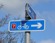
It is now part of the Route 7 Cycle Path from glasgow to Loch Lomond and beyond.
It
saw quite a variety of transients over the years including the Vikings of 1263,
many kings of Scotland visiting their hunting parks on the Lochside or old
Balloch Castle, and Rob Roy McGregor, not only on his Loch Lomond Raid of 1715,
but also as a preferred route on his many visits to Glasgow. The towpath which
was used by horses to pull vessels up the Leven started / stopped at Balloch.
It is now part of the Route 7 Cycle Path from glasgow to Loch Lomond and beyond.
From the late Middle Ages onwards, Balloch Fair and Horse Market was held every September at Moss of Balloch and was not only a leading Horse market in Scotland, but also the main holiday in the Vale. It was dying out in the early 1900's, and the last one was held in 1919. After 1770 when Scotland's main cattle market moved from Crieff to Falkirk, the cattle drives from mid and southern Argyll started to come through the Vale, most crossing the Leven at the ford at Balloch. From about that time too, a trickle of rich people's tourism started. For both the drovers and tourists the Ferry Inn, which became Balloch Inn and then Balloch Hotel, was the only hostelry in miles.
The first steamship on the Loch, the Marion, arrived in 1817, and the transformation of Balloch began. Soon there were other steamers on the Loch and a coach service from the pier at Dumbarton bringing passengers. The first bridge at Balloch was built in 1841, and it lasted until 1887. The one, which was rebuilt and re-opened in 2004, replaced it. It was the revenues from the steamer trade - both passengers and cargo - which attracted the railway to Balloch, and therefore the Vale. Not having enough money to build a line to Glasgow, the first line in west Dunbartonshire ran between Bowling harbour and Balloch Pier, which was built out into the Loch to provide step-on services to steamers in all levels of the Loch.
The railway opened in 1850, and in 1856 a line between Balloch and Stirling followed. It was not until 1858 that there was a direct line from Balloch to Glasgow. Henry Lynn started to rent rowing boats and run pleasure boat cruises about 1880, while John Sweeney followed later in the 1880's.
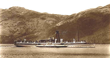
Prince Edward (from an old postcard)
The old houses at Front of Balloch were built from the 1820's onwards to house the men working on the steamers, and later railwaymen. The villas around the station date from late Victorian and early Edwardian times, as does the Tullichewan Hotel. In 1908 trams arrived at Balloch with the tram terminus for the Dalmuir trams being in Balloch Loan immediately to the west of the railway station. While trams lasted only until 1928, they were popular with day-trippers, especially since they ran on Sundays, which the railway didn't do until 1919.
In 1915, the Dennistoun Brown family sold Balloch Castle and surrounding estate to Glasgow Corporation and it was opened up to the public at that time. Management of the Park was passed to the old Vale of Leven District Council in the early 1970's, and to begin with, this worked extremely well. Best to draw a veil over the depredations of the 1980's and 90's, but West Dunbartonshire Council has in the last few years heavily invested in bringing it back to being the jewel that it was.
It was in the early years of the 20th century that privately owned cabin cruisers started to appear on the Leven, and they were followed by a fair number of houseboats. The hey-day of the Balloch cabin cruiser fleet, which sailed every weekend and on which people stayed, was the period 1920's - 1960's. In these years the sight of the “Balloch Flotilla” heading out of the Leven on a Friday night for the islands and favourite bays on the shores of the Loch was a sight to behold.
The post-Second World War period saw a great expansion in housing in Balloch. The early 1950's saw a start to the Mill of Haldane Estate, while by the late 1950's the Mollanbowie Estate had been started by John Lawrence the builders. House building has been the main feature in Balloch ever since, with just about every gap now filled in.
It's impossible to end any description of Balloch, however brief, without an honourable mention of Arcari's Ballroom. This spanned fewer years than memory suggests, being opened from about 1950 until the early 1960's when it was destroyed by fire (although by then it was no longer owned by Mr Arcari). A generation of happily married Vale couples met there. The Waterhouse Inn now occupies most of the site. There is a separate website for Balloch.
Balloch Castle and Park
Old Balloch Castle was one of the earliest headquarters of the Earls Of Lennox. It was a stone built edifice, probably built about 1238, standing on the east bank of the Leven, just as the river leaves the Loch. Part of its fosse or ditch can still be seen, immediately to the east of the park pathway just south of the mouth of the Leven. However nothing else remains visible - it is 200 years since anyone recorded seeing the ruined stone walls - and no worthwhile archaeological excavation has ever taken place on the site.
It was in a strategic location in its day, and the Lennoxes had moved there from a wooden castle at Faslane, partly for greater security. Its questionable if they felt they found it, because they moved their headquarters to a castle on Inchmurrin in about 1390, and that remained their headquarters till the death of the last “real” Lennox - Countess Isabella - at Inchmurrin in 1460. However, Balloch Castle did continue to be used socially by the Stewart Darnleys who frequently entertained royalty there.
One of the Darnleys married Mary Queen of Scots and fathered James VI of Scotland (James I of United Kingdom). Darnley was soon murdered and James was a child when he inherited the Castle, and is not really associated much with the Castle. After he became King of the UK he had much bigger fish to fry anyway. It was ignored by the Stuart Kings and gradually fell into neglect.
The Colquhouns bought the Balloch Estate, which included the old castle, in 1652. They held onto it until 1802, when they sold the estate to John Buchanan, a Glasgow merchant and banker. Buchanan already owned property at Ardoch, Gartocharn. He built the existing Balloch Castle on the hill in 1808-9, to a design by Robert Lugar - also the architect of Tullichewan and Boturich Castles. Buchanan sold the estate and castle in 1830 to Gibson Stott, and in 1845 the Dennistoun-Brown family bought it.
The White Dyke was built about mid 19th century to keep people out of the Park, causing a long running controversy. The Dennistoun-Browns sold the 200-acre estate and castle to the City of Glasgow Corporation in 1915. From then on it became Balloch Park and was thrown open to the public.
Glasgow City Council still owns the grounds, although the day-to-day management and maintenance of the Park is in the hands of West Dunbartonshire Council. Its workers have carried out a £2.4 million renovation recently (2004-7) to restore the Park trees and gardens to the sort of glory which Buchanan and the Dennistoun-Browns spent a century creating. It is an urban myth that Queen Victoria ever visited, far less stayed, at the Castle.
Balloch Road or Balloch Loan, Balloch
Strictly speaking, Balloch Road runs from its junction with Old Luss Road to a notional point a few yards to the east of Balloch Park main gate, where it becomes Drymen Road. However, the stretch of the Road between the Bus Stance and the east side of Balloch Bridge is known as “The Front of Balloch”, and there is a separate entry for the Front of Balloch on this web page. That leaves what locals call Balloch Loan, stretching from the west side of the Old Bridge to the junction with Old Luss Road.
Balloch Loan originally connected the track down Loch Lomondside with Balloch Ferry across the Leven. Even after Balloch Bridge was built in 1841, there was only a single low building on that stretch of road, called Ferryhill. It seems to have been in the way of the railway line, which came to Balloch in 1850, and no mention of it appears after that.
The railway station and the railway cottages beside its western platform were the first buildings of the new era, and remained in splendid isolation on that side of the Leven until the end of the 19th century. Two tracks came off the north side of Balloch Loan from the 1840's. The more easterly went down beside Balloch Bridge to the riverside towpath, where from the late 1870's onwards Harry Lynn and then his sons owned a boatyard and boat-hiring business.
John Sweeney started his yard just north of the Lynns in the 1880's. The other track is now known as Pier Road and led up to the then new pier at Drumkinnon Bay. In the 1890's and early 1900's further buildings appeared on the south side of Balloch Road. These included the Tullichewan Hotel, built originally as a temperance Hotel, which it was until the late 1920's.
At the same time, four private villas, all still standing, were built west of the railway. Across the road, the Anchorage Cottage and Ben Lomond Tearoom appeared in the early years of the 20th century. The Dalmuir trams arrived in 1908, and ran until 1928, coming down Balloch Loan from Luss Road to terminate just outside what is now Pepe's shop. In the 1920's, the Glen Roy Tearooms were built, while just across the Road at about the same time the Bungalow Tearoom was opened.
After a false start in 1929, The British Silk Dyers (“BSD”) opened a factory which occupied all of the land on the north side of Balloch Road up to the BSD's own houses in Drumkinnon Road. The BSD closed in 1980, and in the late 1990's the Clairinish Gardens housing estate was built on the front part of the site. On the south side of the road, in the early 1930's John Lawrence the builder erected a row of detached and semi-detached villas, and these ended at the grounds of the Loch Lomond Hotel, also built in the early 1930's (this is now Laudervale Gardens).
Later in the 1930's, the Glen Roy Tearoom was upgraded to the Glen Roy Hotel, by which name it is still best known, although it was renamed the Lomond Park Hotel many years ago. About 1950, the Bungalow Tearoom was substantially extended to become the Bungalow Ballroom and it featured Scottish Country Dance Bands - Jimmy Shand and Jim McLeod both played there. It changed hands, and in the early 1970's became the enormously successful Wonderland Chinese Restaurant.
That too changed hands, becoming the Manzil Indian Restaurant in the late 1980's, but it burned down. Two buildings arose from the ashes and both are still there - La Scarpetta and the adjoining Hairdressers. The Ben Lomond Tearoom became a pub in the 1960's, was extended, and for years it was well known as Nightingale's Nightclub. It has since been divided into a restaurant and Desire's nightclub.
McArthur's Garage prospered from the 1920's to the 1990's at the junction with Old Luss Road, and only disappeared to make way for the entrance to Lomond Shores. In 1986, Balloch Central Station moved from the north side of Balloch Road to the south side, and the last operational level crossing in the Vale closed. The old station has been a Tourist Centre and temporary HQ for the National Park, whose new premises open in 2008.
Balmaha
There are two possible derivations of Balmaha: “Bal maitheas” meaning town of mercy or the goodness of God” (one of the Celtic towns of refuge for the shelter of fugitives under the protection of the church), or “St Maha's place”. This second derivation seems to be gaining increasing credence, perhaps because of St Maha's Well nearby. There is an entry for Balmaha in the Lochside Villages pages.
Bandry, The
The Bandry is the southernmost of the three picturesque bays just to the south of Luss. The Bandry has strong connections with St Kessog (or MacKessog) who came from Ireland and founded a monastery on Inchtavannach, which is just a few yards across the Loch from Bandry. He was martyred, possibly at Bandry, in 520.
When soldiers were building the Dumbarton - Inverary road in 1746-48, they came across an ancient cairn at the Bandry, in which was a statue of a man dressed in a bishop's robe. No one knows when or by whom either the statue or the cairn was made, or whom the statue represents, if anyone, or why the statue was hidden in the cairn. Again the rule of “time immemorial” comes into play for historians, and basically any half plausible story gets a hearing, because no one can conclusively prove otherwise.
One of the half plausible stories is that this is a representation of St Kessog, and why not? None of this pre-occupied the soldiers too much. The cairn stood in the way of the road, and they demolished it. The statue was removed for safe keeping into Luss Parish Church, where it has remained ever since.
Not
satisfied with the confusion over that statue, the Bandry provides another.
This time the full history is known, but why should that get in the way of
a tall 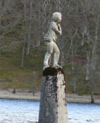 tale? Standing in the Loch in the Bay is a statue of a boy, which many
take as some form of memorial to a drowning in the Loch. That is completely
wrong, and the truth is a very happy story.
tale? Standing in the Loch in the Bay is a statue of a boy, which many
take as some form of memorial to a drowning in the Loch. That is completely
wrong, and the truth is a very happy story.
William Kerr made the statue for a house in London, which he had been commissioned to build. Although by the late 1870's and 80's Kerr was a successful builder in London, as a child Kerr and his siblings had been orphaned and brought up very happily by a lady in Luss. When he was left with the statue surplus to requirements, instead of putting a hammer through it, he thought of his childhood in Luss, and at his own expense, brought it up and erected it in the Bandry in 1890. (Place mouse pointer on image to enlarge)
There it still stands, as a memorial to these happy childhood days in Luss. There is even a photograph of Kerr standing on its plinth out on the Loch, with his arm round it. It was at first known as Kerr's Folly, but seems to be a very wise and honourable folly. It is sometimes now referred to as Wee Peter, but no one seems to know why.
Also at the Bandry there is a former Free Church. It was built immediately after the Disruption of 1843, when Colquhoun of Luss's wife and brother joined the walkout over patronage - unusual behaviour for landowners, who usually owned the patronage. Its congregation reunited with the Church of Scotland in 1929, but it continued as a separate church until 1940, when it closed. It is now a private dwelling.
Bank Street, Alexandria
This is one of the principal thoroughfares of Alexandria, running from the Fountain to Bonhill Bridge, although now only its northern pavement travels the distance in its original straight line. Bank Street was originally called Ferry Loan from about the 1790's, until about 1855 when a local industrialist called Guthrie, who had nothing to do with the national banks, opened his own Bank on it.
What's left of Bank Street Alexandria today
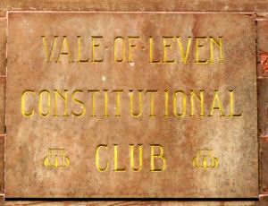
After its name had changed to Bank Street, three of the national banks did open branches on it in the 19th and early 20th centuries. Clydesdale Bank was first in 1862 and then what became the Royal Bank opened in Weir's Building about 1893, while the last was Bank of Scotland, which was housed in the Constitutional Club building from about 1905, until it took over the British Linen Bank and moved to its building in Main Street in mid 1969.
Initially Ferry Loan / Bank Street's importance lay in its connection between the military road and the Bonhill Ferry and then its Bridge. However, as the 19th century went on, it steadily grew in importance as a housing and then commercial centre. By the1860's Bank Street and Main Street were the most important thoroughfares in the Vale, while by the end of the century nearly all of Alexandria's shops were to be found in these two streets.
 Many of the finest of the Vale's
signature red sandstone buildings stood on or beside Bank Street. Nearest
the Bridge was the Public Hall (built 1862).
Many of the finest of the Vale's
signature red sandstone buildings stood on or beside Bank Street. Nearest
the Bridge was the Public Hall (built 1862).
Further up, just beyond the railway which arrived in 1850, with its station initially only accessible from Bank Street, were the Post Office (1904), the Constitutional Club (about 1905), the Co-op Hall and Head Office building (1895), Weir's Building (1893) and Stevenson's Building (1895).
During that period, two other fine buildings were added to Bank Street - the Clydesdale Bank and the Free Church (1889), although neither was built using red sandstone. Other important Bank Street buildings included the first Labour Exchange, Telephone Exchange and Co-op shop; all stood just about opposite where the former Post Office building stands.
The social side of life was not neglected. The Public Hall got a licence to show films in 1911, while in 1914 the Vale's only purpose-built cinema was opened. Initially called the Palace it became the Strand in 1929, and stayed that until it closed in 1978. Its site is now part of the Aldi car park - Aldi was a very welcome addition a few years ago against the trend.
Rock 'n Roll reached the Vale via the jukebox in Bernie di Felice's café. It was Teenage Central in the Vale of the 1950- 60's, and stood almost opposite the Strand. The 1970's and 80's redevelopment destroyed most of Bank Street, directly or indirectly. Most of the shops have now gone, with the Co-op Department Store closing a couple of years ago. Some survivors do stand out. The Paint Pot now occupies McLaren's Pub, and Bobby Biddulph's carpet shop thrives in what started life as an Auction Room and was for many years Taylor's Furniture Store.
The largest building still in use is the Medical Centre, but there are even plans, allegedly, to relocate that. It was built on the site of the Co-op Hall. Redevelopment saw houses and businesses making way for car empty parks and a demented road system. Its time to fix it.
Bankhead, Balloch
Bankhead was two parallel, short lanes, which ran from Dalvait Road to the River Leven, just south of where the New Bridge now stands. It is now incorporated into the Red Fox Estate, but until the late 1960's there were a number of 2 storey tenement houses in Bankhead, of which only the central one remains.
There had been buildings on the site going back over 200 years, including a blacksmiths and a sawmill and joinery shop by the Leven's edge. The joinery shop was converted into the Radium Works of 1915 - 20, which was accessed via Bankhead. The name Bankhead probably started as a farm or smallholding in the 17th or 18th century.
Bannachra Crescent, Alexandria
Bannachra Crescent in Tullichewan was first laid out in the late 1940's, when the first version of Tullichewan Housing Estate was built. Like most of the rest of the Tullichewan scheme of that time, the houses on Bannachra Crescent were prefabricated at Blackburn's ex aircraft factory at Dumbarton, and made mostly from aluminium. They were called “prefabs” or “aluminiums” and that is still how most people who can remember them, think of them.
The highest point in Tullichewan was in Bannachra Crescent, at what is now the bus stop just outside the Hospital. The prefabs were removed in the 1960's and replaced by the present houses. Bannachra is called after the estate / ruined castle at Arden.
Bannachra Muir, Estate, Castle and House, Arden
It is hard to say whether the old Castle and estate were named after the Muir and Hill or vice-versa, but since one old spelling is Ben-uchara, it's quite possible that the hill and Muir were named first. In any event the estate is dominated by the Muir, which rises to a height of just over 1,028 ft. The Castle dates from medieval times and its ruin still stands on the estate, close to the present Bannachra House. It was a Scottish baronial keep, typical for its time and purpose - keeping out neighbouring enemy clans. It was originally a Galbraith castle, but in 1523 it passed into Colquhoun hands.
Here in 1592 a murder took place, which is still shrouded in mystery. The story at the time was that a party of McGregors and McFarlanes attacked the Colquhouns in the Castle. That was a credible enough cover story, but quite possibly untrue. It was further claimed that in the ensuing melee an arrow fired by the raiders killed Sir Humphrey Colquhoun. This arrow was fired in darkness at night, through a narrow window slit, when a candle held by a treacherous servant illuminated Sir Humphrey.
That would have been some shot, certainly unequalled again until John Ford started making westerns, and “Ah hae ma doots” comes to mind. Your doubts would have been well placed, because not long afterwards his own brother was tried and executed at Edinburgh for his murder.
Just over a decade later, there was a real melee with the McGregors a few miles away in Glen Fruin, and about 140 people on the Colquhoun side were killed. It was alleged that this included a party of school-boys from Dumbarton Grammar School, and a mound at Bannachra was / is supposed to contain their bodies.
Another of Bannachra's claims to fame is that from about 1706 until 1731, at the house of a “retired” minister on the estate, a local Gretna Green type of marriage service was conducted - no banns, and no moral or religious questions asked. For some reason, it proved especially popular with couples from Greenock who rowed to Craigendoran, and then walked over the moor to Bannachra. By 1730 it was calculated that one third of all Greenock couples were getting married at Bannachra. It all stopped when the minister died in 1731, aged 92.
The old Castle fell into ruins and was eventually replaced by a mansion, which is small, only by the standards of other Lochside mansions. It was at this house in June 1787 that Robert Burns, on his way back from an unhappy visit to Inverary, was entertained by its then occupant a Mr McLachlan. As was to be expected they had a heavy night and morning of it, coming out about 6 am to toast the sun rising over Ben Lomond. They then left Bannachra, quite possibly to visit and dine at nearby Arden House with Mr Buchanan (who also owned Bannachra), where again they “pushed the bottle”.
It was immediately after leaving the dinner table en route to Dumbarton, that Burns engaged in a horse race with a Highlander, was thrown from his horse and ended up in the bracken, probably somewhere around Cameron Brae. Since it was part of Arden estate when the Lumsdens bought Arden, they also bought Bannachra House, and a member of the family lived at Bannachra until it was sold in 2003.
Barton Avenue, Haldane
This thoroughfare, which was one of the last to be built at the “back” of the Haldane was named after a councillor, John Barton, who served on Bonhill Parish and Dunbarton County Councils for many years as a “Moderate” i.e. Tory. He represented Alexandria East, a heavily working class ward, on the Parish Council from 1907 until standing down in 1928 and he also represented Alexandria West on the County Council 1925-1928. He did not contest the elections to the reconstituted Dunbarton County Council in 1929, but did stand again in 1932 (Millburn) and 1935 (Alexandria West) when he failed to get elected.
He returned for one final election in 1945 in his old seat of Alexandria East but was well beaten by George Halkett, who had held the seat for 10 years by then. There was no change which went unobjected to when John Barton was in a meeting (unless he had proposed it himself) and Dan O’Hare called him the “star dissenter”. In spite of that they were personal friends and Barton showed flexibility and diplomacy many times over the years which belied his reputation for obduracy and was an even-handed chairman of the Parish Council.
Baxter Lane, Alexandria
This short Lane in the Rosshead Estate Alexandria was built in the early 1960’s. There are two possibilities for the source of the name. Firstly it could have been called after Dr Baxter, a local family doctor who had a practice in the Vale for many years. Or, it could have been named after Archie Baxter who was a local councillor in Alexandria in the 1930 – 50’s and was latterly the Vice-chairman of the Vale of Leven District Council. Since he died at about the time that Rosshead was being built and since Colquhoun Drive and Halkett Crescent in Rosshead are named after local councillors, it could well have been named after him.
Beaton Road, Balloch
This street in the Dalvait Estate was built in the early 1970's.
Bilsland Place, Renton
This road in the redeveloped Renton of the 1960 / 70’s is virtually unique in the Vale in that it is mis-spelled. It is named after Walter Bisland, a prominent Rentonian of the late 19th and early 20th century. Walter, or “Wattie” as he was better known, took a leading role in Renton FC and other Renton football teams, was a Cardross Parish councillor and was active in many other civic organisations in the village. He was also a JP, one of the few to actually live in Renton at that time. The spelling of his name is quite definitely Bisland, and not the Bilsland that the Council applied. In spite of the best efforts over the years of Alex Bisland, a descendant, the Council has refused to change it. Wattie would be spinning in his grave if he knew that in spite of his life-time efforts, some council administrators have proved to be education-resistant and can’t spell.
Beechwood, Bonhill
This private housing estate, on the hillside at the south end of Bonhill, was the last of the major housing developments on the hill to get under way. It was started in the late 1970's, but mostly dates from the 1980's. Unlike its near neighbours on the hill, it has street names - Beechwood Drive, Murroch Crescent (after the nearby Murroch Glen), and Broomhill (after the adjacent Broomhill Wood).
Black Hill, The
“The Black Hill” is the name locals give to the B831 / 832 road from Arden roundabout to the Cross-Keys roundabout, and on to Helensburgh. The road initially runs through Glen Fruin, and further north on Glen Fruin, well after the Black Hill road has swung west at the Cross-Keys, is the Black Bridge. There is no direct connection with the road.
Black seems to be a theme in the Glen, as it could be in any number of Highland Glens. It could be related to the slaughter of the Colquhouns by the McGregors at the battle of Glen Fruin in 1603, but that is pure speculation and the darkness of the Glen is just as likely a source for the name of the road.
More information on the Black Hill is available here.
Boathirers at Balloch
One of the main attractions of Balloch over the last 130 years or so has been the boathirers yards on the banks of the Leven. There, people could go for a cruise on Loch Lomond on what were initially steam, then later motor, launches. Alternatively, they could hire rowing boats, and eventually small motorboats were also available. The two families most associated with these yards have been the Lynns and the Sweeneys.
The Lynns were the founders of boat hiring at Balloch. In the late 1850's Harry Lynn started work as a boatman helping to tow scows up the Leven and the Loch using a steam launch. In later years he started his own yard building and repairing boats, as well as towing. The last horse-towed barge is reckoned to have come up the Leven in 1874, and by that time even steam towing up the river was in decline, losing out to the railway. Lynn had spare capacity for his steam launches, which he used to take tourists out for a cruise on the Loch. He added a few rowing boats for the more energetic visitor, and around 1880 a new tourist attraction was born. His boat yard, which continued with the repair and building business, was on the west side of the Leven, immediately north of the old Balloch Bridge.
A few years later, John Sweeney, who had been a textile worker in the Craft, opened his yard just north of Lynn's, also on the west bank. He too rented out rowing boats and took people for cruises in 2 steam launches he had. Business boomed. Harry Lynn's sons, Tom and Isaac, succeeded him in the early 1900's. Also about this time, a Mr Walker started to operate a motor launch on the south side of Balloch Bridge, but still on the west bank. All these businesses operated on what now seems a comparatively short stretch of land from the Bridge to the Railway's Coal Pier, just north of the Humane Society's Shed.
In 1911-12 the Sweeneys and the Lynns were thrown into some disruption by two apparently contradictory rows about public access. The first and best known was the Sweeney Case. John Sweeney was sued by the riparian owner, James Campbell of Tullichewan, for anchoring a jetty to the bed of the river. There was considerable public support for David (Sweeney) against Goliath (Campbell, the landowner), but Sweeney lost. Also in 1911, Tom Lynn wanted to open a yard on the east bank of the Leven in front of the Balloch Hotel. Public protests ensued against what was wrongly seen as access restrictions. After a time they died down, and Tom Lynn opened his new yard. His brother Isaac kept his yard on the west bank.
About 1920 Bob Roxburgh opened a second yard on the east bank, this time on the south side of the Bridge, on what had previously been a marshy field. After John Sweeney died, Maggie Sweeney took over. She bought Bob Roxburgh's yard in the 1930's, and then sold it to the Blair's, who owned it in the 1940's and 50's. They in turn sold it to Harry Lynn, son of Tom, in the 1950's. Harry at that stage therefore owned both yards on the east bank. However, he vacated the northern of the two yards in the early 1960's and the site was converted into the substantial riverside walkway, which it is to-day.
Harry Lynn sold the southern yard to Nigel Stead of the Gratispool family, about 1970. He in turn sold it to the Mullens who had it for over 20 years, before selling it a few years ago to John Sweeney. John Sweeney owns the two remaining boat-hiring yards at Balloch, although his boats sail only from the west bank. That yard has not been in continuous Sweeney ownership since 1880. Maggie Sweeney sold the old Sweeney site when she moved to the east bank, and a Mr Hynd ran it for about 20 years after the Second World War. John's father, John senior, brought the yard back into Sweeney ownership in the 1960's. On his death in 1984, his son took over, and the business has gone from strength to strength.
There were two other boat-hiring stations at Balloch, which are worth a mention. The first of these was at Drumkinnon Bay and was called Hogg's Yard. It operated in a field, roughly where the excavated Lomond Shores pond now is, from the 1920's to the early 1950's. The other one was at Lennoxbank House Hotel where about 1960 its owner, Harry McGhee, started a cruise business called Lomond Marine Cruises, using waterbuses specially imported from Holland. It lasted about 10 years.
Boll or Bowl of Meal, Alexandria
This is the original name of the Park in which Rosshead housing estate now stands. The bowl of meal would almost certainly have been the annual rent, which a farmer in the middle ages would have paid the landowner for the use of the park. It eventually belonged to the UTR, whose Croftingea Works were adjacent to it across the Heather Avenue.
By the 1950's, it was both a football park and a cricket park. The UTR works team played there, as did their ladies team, the famed Craft Cuties. It's not hard to imagine which games drew the larger crowds to the Bowl of Meal. The much-travelled Vale of Leven Cricket Club moved from the Argyll Park to the Bowl of Meal for a few years in the mid to late 1950's. When work began on Rosshead in the early 1960's, they were once again homeless and moved back to the Argyll Park for a number of years.
Bonhill Parish
As befits the oldest named part of the Vale, (it is mentioned in a charter of 1270 as “the parish of Buthehille”) and the Parish in which most of the Vale is situated, there is a choice about the origins of the name Bonhill. There is firstly, a belief in the Gaelic “bog n'uill” meaning the foot of the rivulet i.e. the Burn. If you don't like that, then you can have the foot or base of the hill. Buthelulle then became Bollul. And if you didn't like either of them (and who would?), by about 1550 it was Bonyle, then Bonuil or Bonill, and finally settled for Bonhill by 1700.
To begin with, Bonhill was a small, poor parish. It was enlarged in 1650 by the annexation of lands from neighbouring Kilmaronock and Luss Parishes, and its boundaries have remained unchanged ever since, although political and administrative boundaries have changed many time since.
The parish is about 5 and half miles long (north to south) and between 2 and 3 and a quarter miles wide (east to west). At the south end of Loch Lomond, 2 miles of the western shore and three quarters of a mile of the eastern shore are in Bonhill Parish. The southwestern boundary is the Poachy Burn at Millburn where the Parish of Cardross begins. Renton is therefore not in Bonhill Parish, the only Vale town or village not to be so.
Dumbarton Parish begins at the north end of Strathleven Industrial Estate. Kilmaronock parish begins at Ashfield House on the Gartocharn road, and Luss Parish at the Arden roundabout. A church for the Parish is mentioned in the 13th century, but it is not known what sort of building it was, or exactly where it was. It would certainly be small, because even by 1643 there were only 120 communicants in the Parish, implying a total population of about 350.
It remained rural, sparsely populated and poor until the arrival in the second half of the 18th century of the bleaching and then dyeing industry. Ironically this came initially to Dalquhurn in Cardross Parish, but quickly spread up-river. By then there was a church in the area of the present Bonhill Parish Church, probably built about 1700. In 1747, the first of the modern Bonhill Churches was built and by then the parish's population had grown to 901.
Today, a parish is seen almost exclusively as a church organisation. However, until quite recently and for centuries before that, it was not only an ecclesiastical unit, but was also used as the lowest level of local government administration. Although its powers were meagre they were important. Its main responsibilities were the provision of schools, and the administration of poor law. In 1894 this was formalised into a Parish Council organisation. From 1894 until 1929, when it was abolished under local government legislation, there was an elected Bonhill Parish Council. Right until its demise the Parish Council continued to have responsibility for poor relief, which is where the phrase “going on the parish” came from.
Bonhill Parish Council still has its footnote in history books, because during the 1920's slump, it decided to set its own level of relief payments - higher than those of the government. The government went to law on the matter and naturally won, for what that's worth. When 1929 local government re-organisation saw the replacement of the Parish Council with the Vale of Leven District Council, the new Council included Renton (and central government took some responsibility for relief payments for the first time). So, administratively as well as geographically, Renton and the Vale were one for the first time.
To confuse matters further, there was also a separate Bonhill Parish School Board from 1872 to 1918. The only government context in which the Parish has any meaning to day, is in the Registration of Births, Marriages and Deaths. It provides the basis for counting the population of exactly the same geographic area over the centuries. From 1650 when the population of the whole parish was about 350, it has grown steadily. In 1750 it was about 901, 1801 - 2,460 and by the time the present Parish church was built in 1835, the parish population was about 6,500. In 1901 it was 14, 581, 1921, 16,622. It took a dip below 16,000 during the Depression, when people left in droves to find work, not getting back above 16,000 until 1951.
Bonhill Village
For the origins of the name Bonhill, see the entry for Bonhill parish above. Bonhill is the oldest place name of the Vale towns and villages, and a church has carried the name since the 13th century. There was a very small church building at the beginning of the 18th century, just about where the present church is and the first modern church was built in 1747 close to the river. In 1835 the present church was built, but from 1830 onwards there was no shortage of churches in Bonhill. Mount Zion in 1831 as a Relief Church, a replacement Parish Church in 1835, and a Free Church in 1843, which became the South Church. All were still open up until the 1960's, but now only the Parish Church survives.
Apart from an early church, the other point of note was a ford across the River Leven, which is still there. Drovers taking their cattle from Argyllshire and the Lochside to market in Glasgow used this ford. As early as 1664, the drovers were calling this trade “past memory of man”.
At the peak of textile finishing in Bonhill in the 1840's, Bonhill had 4 textile works in operation. The oldest was Dalmonach Works, a printworks that started in 1786, was burned down in 1812 and rebuilt by Henry Bell of the steamship The Comet fame. It closed in 1929, was used an army barracks during World War Two, and then by a variety of smaller companies before being demolished in 2006. A new private housing estate is presently being built on the site, with many houses already occupied.
Dalmonach Works was notable for having a school attached to it which taught not only children who were employed in the works, but pupils from as far away as Dumbarton. It is a listed building and has survived the demolition, standing just outside the original Main Gate of the works. The second works was the Wee Field, which opened in 1793. It was wedged between the Parish Church, Main Street and the Burn, and it closed in 1840. There is a very good engraving of the Wee Field, which includes the present Parish Church and the old Main Street buildings - it is the earliest illustration that there is of Bonhill.
Dillichip Works opened in 1820, and by 1830's was employing over 500 people. In 1875 a branch railway line was run into the works which entailed building a railway bridge over the Leven. It survived until its closure in 1936, but was subsequently well used. During the war it was a REME depot, and after that it was for a number of years a store for J & P Coats, suffering a major fire in 1950. It is presently a bonded warehouse, but a number of the old factory buildings survive virtually intact, and it is quite recognisable as the Dillichip of old.
In 1836 the 4th and final works was started, just south of the churchyard, close to the river, but entered from Main Street. This was Kirkland Printworks, which only lasted about 30 years and was demolished in 1868.
In 1836 Bonhill Bridge was built over the Leven. It was quite wrongly built as a toll bridge for which the toll was a halfpenny, which earned it the name of the “Bawbee Bridge”. The tolls were the source of considerable anger for almost 60 years until they were abolished in 1895.
With the growth of the textile works, the village steadily expanded during the 19th century firstly along Main Street from Dalmonach to Dillichip Terrace, and at the same time and in similar numbers, astride the Burn. The various streets in Braehead soon followed. By the 1820's there were a number of small businesses in Bonhill including a distillery, a nail factory, and a blacksmith's shop. An impressive aspect of the Main Street by the closing years of the 19th century was the number of shops on it from Bonhill Bridge to the top of the Brae.
The existing Bonhill Primary school was opened in 1874, and while St Ronan's, High Dykes and Ladyton primary schools have all opened in the hillside estates of the 1960's - 80's, it soldiers on. In the 1880's houses began to be built on Ladyton public park, and they became part of George Street. The green space there was finished off in the 1920's when council houses were built on it.
McDougall's Lemonade (or ginger!) factory opened in Croft Street Lane about 1884, and operated from there for over 100 years. The red sandstone Co-operative Society houses on Union Street were built in 1900, while the Golf Course at nearby Northfield opened in 1907. The Burn was at last covered put into a tunnel and Burn Street covered over in 1929. New council houses were also built in Hillbank Street in the late 1920's.
Immediately after the Second World War, work began on Dalmonach Housing Estate and its new residents came from both Bonhill and Renton. The only downside to the overwhelming benefits of Dalmonach Estate was the loss of one of the Vale's most famous names and walks - the Slunger, although Northfield Road follows most of the line of the Slunger. The building of the new estates on what had been Ladyton and Nobleston farms: O'Hare, Ladyton, Pappert, Nobleston, Redburn, High Dykes and the private developments at Strathleven Park and Beechwood, did not have any initial impact on the old village of Bonhill. By the 1980's however, it was decided to make major road alterations and the main road from Dumbarton to Balloch bypassed Bonhill village.
Part of that re-alignment was the destruction of most of Burn Street and the area around Hillbank Street and Bonhill Quarry. That might have been a price worth paying if the so-called road improvement had not totally overlooked the need for a southbound filter lane at the Bonhill Bridge junction.
The middle of old Bonhill village has more gap sites than seems possible in the land-hungry Vale, while Campbell Street's surface could be used for road testing lunar vehicles. A little TLC would not go amiss. As for the rest, Bonhill now probably has as large a population as Alexandria.
Bonhill, Place of, Alexandria (by a few feet!)
This is a name of very long standing, and was for centuries a House, and is now a Road and area - the location for both the Vale of Leven Academy and St Martins Primary school.
These days we are a bit confused by the name, expecting it to be in what is now the town of Bonhill, but of course Bonhill in the title refers to the Parish. The site of the house called Place of Bonhill was between the entrance gate to Academy and the playground of St Martins. The original house was built in the 16th century, but in 1684 the newly enriched Smollett family, who were until then merchants in Dumbarton, acquired it.
From the Place of Bonhill property, the Smolletts acquired the right to style themselves Smolletts “of Bonhill”. They lived at the Place of Bonhill until 1763 when they acquired Cameron Estate and House. However, they retained Place of Bonhill and it gradually fell into a dilapidated state until taken over in 1806 by John Turnbull, a partner in William Stirling & Sons and owner of the nearby Millburn Pyroligneous Works, which he started in the 1790's.
The road currently named Place of Bonhill is actually Turnbulls or Truml's Loan and is named after the Turnbull's of Place of Bonhill House, as is Turnbull Crescent in Burnbrae. The Turnbulls leased the land on which Millburn Park stands to Vale FC in 1888, on very advantageous terms. They left the area when they sold the chemical works, in the early 20th century, but Place of Bonhill was converted into flats and in constant habitation until the late 1950's. The last householders there - who included the Flowers family, who had been there for decades - only moved out because it was being demolished to make way for the Vale Academy.
Bottle Linn, the
This is located where the Bonhill Burn runs into the River Leven, a few hundred yards south of Bonhill Bridge, just before the churchyard. A linn is a sandbar, caused in this case by the sand and gravel washed down by the Burn. Until 1927, the Burn ran open along Burn Street Bonhill and people dumped their rubbish into it. The empty bottles floated down the Burn, through the tunnel under the Main Street and out into the Leven, where they got caught on the Burn's Linn. Hence the Bottle Linn
Boturich Estate and Castle, Balloch
Boturich Castle and Estate are featured in many charters from the middle ages, and the “twa Boturichs” are listed in the Partition of the Lennox settlement of about 1493, when they passed to the Haldane of Gleneagles family. It was a substantial estate on one of the most picturesque spots on the Loch, and remained in the hands of the Haldanes until 1811, when they sold it to John Buchanan. Buchanan, who was a Glasgow merchant, already owned Ardoch at Gartocharn, a couple of the farms on the Boturich estate, and Balloch Estate, which he acquired from the Colquhouns in 1802. He was therefore a substantial landowner on the southeast shore of Loch Lomond.
In 1830 he retained Robert Lugar, who was also the architect of Balloch and Tullichewan castles, to rebuild the ruined Boturich Castle. The new build incorporated at least one wall from the old castle, and it was occupied by 1834. After Buchanan's death in 1839, his grandson Robert Findlay bought it. The Finlay family, “East India merchants”, continued to own and live in the castle until the1980's. Boturich Estate is the southern boundary of Kilmaronock Parish.
Braehead Estate, Bonhill
This housing estate on the hillside above Bonhill, takes its name from the old Braehead area of south Bonhill, but is about a half a mile from it at its nearest point. It was the last of the hillside estates to be built by the council, dating from the 1970's. It lies just above Redburn and south of Pappert. It is another single name, numbers only estate. High Dykes Primary School is located in the estate.
Braehead, Bonhill
This is the area of the south end of Bonhill, stretching as its name implies from the top of the brae to Bonhill's southern boundary. It was also the name of the old County Council election ward, which delineated the area pretty well.
Brandy Castle, Dalmoak
This is the nickname given by locals to Dalmoak Castle after it was built in 1868-9 by an Ulsterman, James Aitken, who was a brewer and distiller, hence the nickname.
Brawley's Park, Alexandria
This was a field in Smollett Street, Alexandria, long disappeared under villas, in which a man by the name of Brawley used to graze his cows, while tending his market garden near the Crescent, beside the Leven at Bonhill Bridge. No, we don't know where he came from, but presumably he took his cattle with him to save his own grazing, and if this was the nearest he could get to the Crescent, it must have been in the 1870 - 80's after Bridge, Leven and Thomas Streets began to encroach on Parkneuk at the Crescent, and before the Smollett Street houses were built.
Bridge Square, Alexandria
The outline of three sides of the square is still quite recognisable. It lay at the immediate west end of Bonhill Bridge where Bank Street and Bridge Street both terminated on its western side with the Public Hall standing, as it still does, between these two roadways. On its eastern side two minor roads went down onto the towpath on either side of the Bridge, as two roads still do. The southern of these two roads turned into the Crescent at the Cosy Corner pub.
What is missing is the southern side of the Square in which there were a number of Co-operative Society tenement buildings with shops on the ground floor and flats upstairs. The shops included a butcher, a chemist, and a grocer, but they did change function from time to time. There was also Mary Biagi's café. The Square was laid out after Bonhill Bridge had been built in 1836, and the south side was demolished in the 1970 redevelopment.
Bridge Street Church, Alexandria
This fine red sandstone building was erected in 1908 by a United Free congregation that up until then seemed to have found it difficult to settle in any spot for too long. It was located on the south west corner of the Queen Street / Upper Bridge Street junction. The congregation merged with that of Alexandria Parish Church to become St Andrew's Parish Church in 1987.
Thereafter the Church lay empty for a number of years as various attempts were made by developers to comply with planners' restrictions, which reflected the Listed status of the building. It burned down one night, and the site was subsequently used in the late 1990's to build the five detached houses that now stand on it.
Bridge Street, Alexandria
Bridge Street originally ran the whole way down from Alexandria Main Street to Bridge Square at the western side of Bonhill Bridge. The Bridge was opened in 1836, and the Street obviously takes its name from it. Equally obviously, it was laid out at about the time the Bridge was opened. However construction on it was not continuous. Buildings were erected whenever land and money became available, in a piecemeal fashion. There could be decades, therefore, between the ages of adjoining buildings.
The New Bonhill Bridge
There were many fine red sandstone buildings in Bridge Street. These included the house of the headmaster of Main Street School, a tenement building with a pend close giving access to a garage, complete with petrol pump, the Baptist Church (still standing on its own), the YMCA, demolished to make way for new private flats in the 1990's, and Andy Lynn's pub which reputedly took its cue from the Windmill Theatre in London, and never closed.
The Quoiting Club and the Albert Hotel stood at its western end. Both escaped the vandalism of the 1960's and 70's, but succumbed to later economic and social changes. Only a stump of the original Street survives between the railway and Main Street, and a few yards at the eastern end. In these few yards, however, two older buildings survive - the Baptist Church as mentioned, and the building that houses the Laughing Fox pub.
Brock Hospital, Alexandria
The Henry Brock Hospital, to give it its full name, was gifted to the people of the Vale in 1924 by Mrs Brock, the widow of Henry Brock. Colonel Henry Brock as he was often styled (he was a Colonel in the Volunteer Movement and then the Territorial Army) was a local businessman who was amongst other things a director of the UTR and Scottish Amicable Life Assurance Society. He was also the Unionist candidate for the County of Dunbarton hoping to succeed Alexander Wylie in the 1906 election. That election, however, was a Liberal landslide; Brock lost and he never became an MP. He had strong local connections, since his father owned Auchenheglish House for many years in the late 19th Century and Henry Brock and his wife lived there for a time before they bought Darleith House and Estate, on the Cardross side of the hill although it is in Bonhill Parish, in 1907. They were living at Darleith when Henry died in October 1915 and the Brocks never at any time lived in Broomley House.
His will was not published until 1919 when it was announced that he had left a bequest of £15,000 which was to be used for the benefit of the people of the Vale of Leven, as his wife saw fit. Mrs Brock let it be known that her preferred option was to use the money to open a hospital in the Vale. No doubt she was influenced by the appalling casualties of the War and the great many survivors who were still needing hospital treatment in the Vale as in every other community in the UK. A search was started for suitable premises and when the whole Tullichewan Estate was put up for public auction in May 1922 she bought Broomley House for conversion to a hospital. The work proceeded over the next 18 months or so and it officially opened in 1924.
The Brock Hospital was the first Hospital in the Vale and was a great boon to the area. It was a sort of cottage hospital “plus”, and handled accident and emergencies, and general hospital work, although all major cases were transferred to the Western Infirmary in Glasgow or elsewhere as appropriate e.g. Killearn Hospital. It was replaced by the Vale of Leven General Hospital when that opened in 1957, the first completely new hospital to be built in the UK after the Second World War.
The old Brock Hospital was, however, kept open at that time as an old people's hospital, and only closed when the new Geriatric Unit was opened at the Vale Hospital. It was demolished shortly thereafter, and nothing of it now remains except the trees which surrounded it and which now surround parking spaces at the top of the hill facing the main entrance to the Hospital.
Broomley House, Alexandria
There have been a number of spellings of Bromley (pronounced “Broomley”) Estate over the years – Broomlea, Broomlie and Broomilie being amongst the most frequent in addition to the two already mentioned. It had a history going back centuries, but because of its proximity to Tullichewan Castle, the fact that it came to share a south drive with the castle, and because the Campbells owned them both for nearly 80 years century, it is often assumed that it's a sort of adjunct of the Castle. However, a Robert Carmichael built Bromley House, probably at about the same time as Tullichewan Castle was being built, i.e. in the 1790's, but that is quite coincidental.
For much of the early part of the 19th century it was owned by the Misses Alston who are said to have been relations of the Smolletts. Since the last of them, Elizabeth, was 85 at the time of the 1841 Census it seems that it was on her death that Broomlie, as it was called at that time, was bought by William Campbell shortly after he bought the adjacent Tullichewan Estate in 1843.
The first detailed maps date from after the acquisition of Broomlie by Campbell and they show that by that time Bromley shared a south drive and lodge (the one opposite the main gate of the ex Torpedo Factory) with the Castle. It did however have its own north drive and lodge, and the lodge still stands, a private residence, on the west side of Luss Road immediately before the start of the Tullichewan Housing Estate.
Opening of Broomley House as a Hospital in 1924 (CLICK TO ENLARGE)
Broomley, as it became known under the Campbells, remained in the ownership of the Campbells of Tullichewan until the public auction of Tullichewan Estate in May 1922, when it was bought by Mrs Brock to house the Henry Brock Hospital (see above). While the Campbells owned Broomley, it was usually occupied by a family member, of which there was no shortage.
One of James Campbell’s sisters who was married to General Frederick Gildea lived there with her husband for a number of years. It was their home address while both were serving in South Africa during the 1st South African or 1st Boer War 1880-81. Gildea was in charge of the defence of Pretoria and he named part of the town’s defensive system “Fort Tullichewan” in honour his wife. After the Campbell Trustees sold it to Mrs Henry Brock in 1922 it was converted to the Henry Brock Hospital (see above) which opened in 1924. Even after the opening of the Vale of Leven General Hospital in 1957, it continued in use as an old people's unit, only being demolished after the opening of the Geriatric Unit of the Vale Hospital.
Brooke Avenue, Balloch
This road in the Haldane dates from about 1954 in the first phase of the building of the Haldane. It is named after Willie Brooke who was the Labour MP for Dunbartonshire from 1929 - 31. He was defeated in the National government landslide of 1931, and while he returned to parliament as a Labour MP, he didn't do so for Dunbartonshire. That wasn't surprising really, since he came from Bradford. Perhaps the fact that he was an official of the Amalgamated Society of Dyers helped him get selected to stand in Dunbartonshire in the first place.
Broomley Crescent, Alexandria
Only the southern part of Broomley Crescent still exists in Tullichewan, but originally, when aluminiums stood on it, it was a full crescent, which rejoined Luss Road further north. It was originally laid out about 1950, but the aluminiums were always meant to be temporary, and when Tullichewan was redeveloped in the 1960's, new road layouts were used to make more effective use of the house-building land. Broomley Crescent was curtailed. Broomley comes from Broomley, or more accurately, Bromley House, which was adjacent to Tullichewan Estate, and was the Vale Cottage Hospital at the time.
Brown Street, Haldane
This street in the heart of the Haldane dates from about 1954. On it were built all of the original shops in the Haldane, including a chemist, newsagent and grocers (for about 50 years, the Co-op, but which has been closed for the last few years). The street is named after James “Lawyer” Brown, who was as his nickname suggests, the leading lawyer in the Vale in his day. More than that, he was also clerk and legal adviser to the old Parish and then District Council. He was succeeded by his son who had his offices in Bank Street in the Constitution Club building, and practiced until the 1970's in the firm of McArthur Brown.
They were both very generous with their time and many organisations and individuals benefited from their free help. Both of the Browns well liked and respected figures from the days when streets could be named after lawyers without a public outcry.
Buchanan Avenue, Haldane
This dates from about 1954. There are a number of possibilities for the origins of its name. Firstly, the Buchanan family were the dominant clan in the south-east shores of the Loch for centuries until financial problems forced them to sell out to the Grahams who became the Dukes of Montrose. However, they did stay on in Ross Priory and then in other smaller estates at Gartocharn. It was probably after this family that Buchanan Place in Jamestown was named in the early 19th C. This was a tenement building at the north-west end of Burnside Crescent in old Jamestown, close to where the chip shop now stands on Main Street.
The tenement was knocked down to make way for the last phase of the Haldane development in the early 1960’s, the building of the Davidson Road area. It was very much still standing when Buchanan Avenue was built so its unlikely that it was the source for Buchanan Avenue. The most probable source was a Vale of Leven District Councillor from the 1930’s, William Buchanan, who represented Millburn in Alexandria. The local councils of the early 20th C were a rich source of names for many of the street / avenue / quadrant names in the Haldane.
Buchanan Castle, Drymen
This baronial pile is now a ruin, having been striped of its roof to avoid paying rates in 1955. It was the home of the Duke of Montrose, but was in fact a comparatively recent building, having been constructed by the Duke in 1854 to replace a previous House, which was destroyed by fire in 1852. This previous house is now referred to as the Buchanan Old House, and the remaining parts of it are incorporated into the clubhouse of Buchanan Castle Golf Club.
The Golf Club is also owned by Montrose and was opened in 1936, partly on land on which there had been a racecourse and gallops. The name Buchanan is derived from the Buchanan clan who were the previous landowners in the area. Their ownership dated from a grant of land by the Earl of Lennox in 1225, which grew over the centuries to the estates of the chief of the Buchanan Clan. When the clan chief died in 1681, he left such enormous debts that the estate had to be sold in 1682 to the 3rd Marquis of Montrose, who had no previous land ownership on Loch Lomondside. The Marquis, subsequently Duke, of Montrose, was of course Rob Roy's sworn enemy and Rob Roy hardly missed an opportunity to extract what he saw as revenge from the Duke's estates and employees.
In spite of Rob Roy's best efforts the Montroses prospered - elevated to a Dukedom in 1707 as one of Burns's “Parcel of Rogues”. By the late 19th century they had their own first class railway coach specially reserved for them and kept in a special siding at Drymen Station to be taken out on the Balloch-Stirling line as required. These coaches brought many exotic visitors to Buchanan Castle such as the Shah of Persia and Prince Fujian of Japan. King Edward VII also visited the Castle - but he arrived by horse and carriage - at least until the gate on the Drymen Road where estate workers replaced the horses and drew the carriage up the driveway to the castle.
The castle's main claim to fame in the 20th century was that during the 2nd World War, Buchanan Castle was used as a military hospital and it was to it that the German Deputy Fuehrer, Rudolph Hess, was taken immediately after he crashed landed at Eaglesham in May 1941, in a vain attempt to meet another Scottish Duke, the Duke of Hamilton. Perhaps Hess' presence left some contagion, because by the 1960's the then Duke was living in Southern Rhodesia, a firm believer in racialist white supremacy rule, and a member of Ian Smith's white government which was in open revolt against the British government. In spite of this, no action was ever taken against him, and the Montroses are still in Drymen, but not in Buchanan Castle.
Burma Road, Renton
This is the nick-name of Cordale Road, given to it by a Renton wag (it is often attributed to Johnny Kane) because of the length of time and effort it was taking to complete it, when the first Cordale housing estate was being built in the 1930's - 40's. The original 350 mile long Burma Road was opened in 1938, having been built by 20,000 Chinese labourers to supply the Chinese Nationalist leader Chiang Kai Shek in his fight against the Japanese. It runs through the jungles of northern Burma (now Mayanmar), over parts of the eastern Himalayas and then across a long Chinese wilderness. It was a Herculean task in an inhospitable terrain and climate.
Cordale Road, on the other hand, ran a few hundred yards from Main Street, down a gentle slope, into the flat heart of the Cordale estate. Guess which one took longer to complete.
Burn Street, Renton
This is one of the core streets of the old Renton, about the same age as its near neighbour Thimble Street (i.e. probably laid out soon after it was decided to build Renton in 1762). Also like Thimble Street, it runs eastwards from Main Street, down towards the river, where it turned north-wards for a short way to meet the east end of Thimble Street. It was probably named after a Burn coming off Carman Hill. Burn Street has just about survived and with the new Very Sheltered Accommodation building going up on its south side and the chemist and medical centre at its north side, it may just about resume its status as part of a rejuvenated, busy Renton Cross.
Burn Street, the Burn Bonhill
Burn Street was the oldest part of the village of Bonhill, dating from the late 18th century. It is called after the Burn of Bonhill (from which Bonhill itself takes its name) and indeed the Burn ran down the north side of the Street. However, as well as being an original source of domestic water, it was also an open sewer, and the source over the years of many infectious disease epidemics. After years of campaigning it was at last covered over in 1929.
Burn Street ran from the Quarry to the Main Street and was part of the old drove road, which ran up Hillbank onto the hill. In spite of its downside, it was very much the beating heart of Bonhill for nearly 200 years, although there are only a few yards of it left now. As well as houses, there were many shops, clubs - including a Vale FC Supporters Club - a blacksmith who was there until the end, a cooperage and a nail factory at one time. The first independent subscription school in Bonhill was in the Burn for over fifty years. There were at least two generations of housing developments in Burns Street, firstly just before 1800 –1850 and secondly in the 1920's when many of the remaining older houses were knocked down and a number of gaps left between the tenements. Up until it was almost completely flattened and re-aligned to create the new road up to Ladyton, Nobleston etc in the 1960's it did manage to retain the lively age-old character of the Burn.
Burnbrae, Alexandria
This was one of the first post-First World War County Council housing estates to be built in the Vale. It was started in the 1920's and finished in the 1930's. The red sandstone houses there and at Hillfoot in Renton were about the last houses in the Vale to be built with the stone from the Bonhill Quarry that gave so many Vale buildings their defining colour and character. The name has no external origins, other than that the scheme is unarguably at the foot of a brae down which a burn flows.
Burns Street, Alexandria
This street in Levenvale, Alexandria, which was built in the mid 1930's, is named after Robert Burns, Scotland's National Bard. For many years - until about 1980 - the last remaining “Hut” stood in an alcove in Burns Street, now called Wilkie Place. It was used as a de facto community hall.
Burnside Crescent, Jamestown
Burnside Crescent is one of the thoroughfares of old Jamestown, and used to run from Arthurston Road behind the Church and School and come out on Main Street opposite Jamestown Dam. It took its name from the Inler Burn alongside which it ran for most of its way.
Many of the tenements which stood in the Crescent were knocked down when the final stages of the Haldane were built in the late 1950's / early 1960's. Until that time Burnside Crescent was not a made up road, but more of a stoney track. The building of the Davidson Road houses more than halved the length of the Crescent, and left it a cul-de-sac.
![]()