JAMESTOWN
Of all the Vale towns and villages, Jamestown is the only one whose identity is under threat from within the Vale. The main culprit was the building of the Haldane which very much blurred the boundaries of the village, but in recent years estate agents have not helped either, with properties in what has been Jamestown for 200 years periodically advertised as being in Balloch. Does any of this matter? Well you would like to think that accuracy always matters. But of equal importance is that local identity is fundamental to the well being of every community.
The invariable social consequence of the erosion of local identity is that “nobody cares” soon becomes the prevailing ethos, and there is no need to add to that. For years Jamestown's boundaries have been defined as: the southern boundary is the Sandbank Burn, the northern boundary is the Carrochan Burn, to the west the boundary is the Leven, while to the east the boundary is not as well defined being an arc from the eastern end of the Inler along the Rickett Moss to Auchincarroch Road and down that Road to the former branch line to Dalmonach and along it to the Sandbank Burn.
The village of Jamestown grew up around the junction of the southern road to Balloch Ferry or Boat, from the Dumbarton - Stirling road, or more accurately track, until it was built up into a military road around 1755. This road down to the Ferry over the Leven is now called Dalvait Road, and indeed has been called that for at least 250 years. References to the land of Dalvait go back to at least the 16th century and its Gaelic derivation from the “field of boats” indicate that the area was used by fishermen who fished for salmon in the Leven at designated places or “shots”.
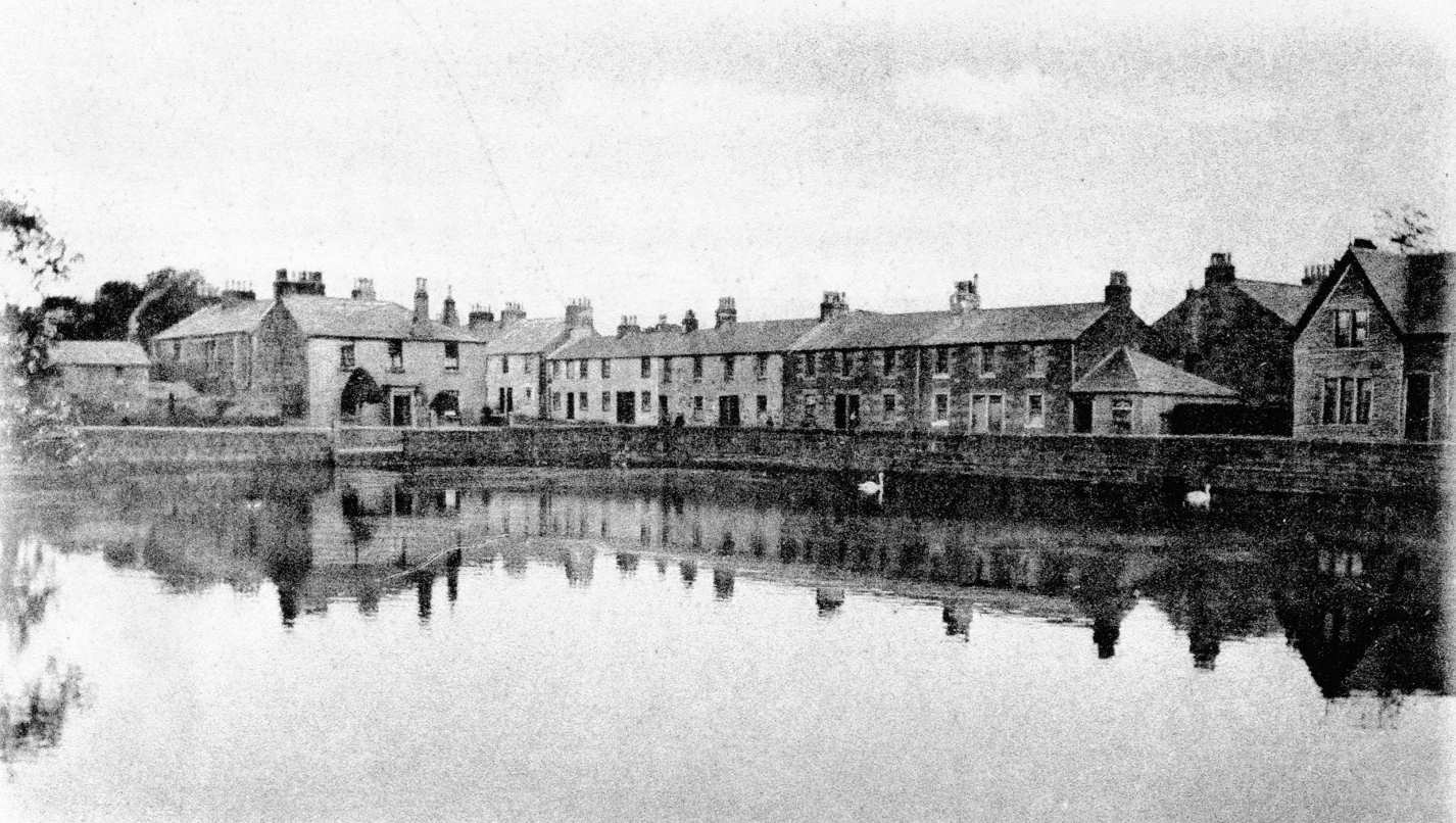
Dalvait features prominently in the origins of Jamestown, for two reasons. Firstly, the Mill of Balloch stood close to Dalvait Road, where it crosses the Carrochan Burn, and it was from the dam for this mill that Jamestown took its first name. The mill was originally driven directly by the Carrochan Burn, its waters being controlled by a dam which was built at the confluence of Ballagan and Carrochan Burns, just behind where Balloch Library now stands This dam was swept away in a flood about 1850, to be replaced by Jamestown Dam which was the centrepiece of the village for about 100 years.

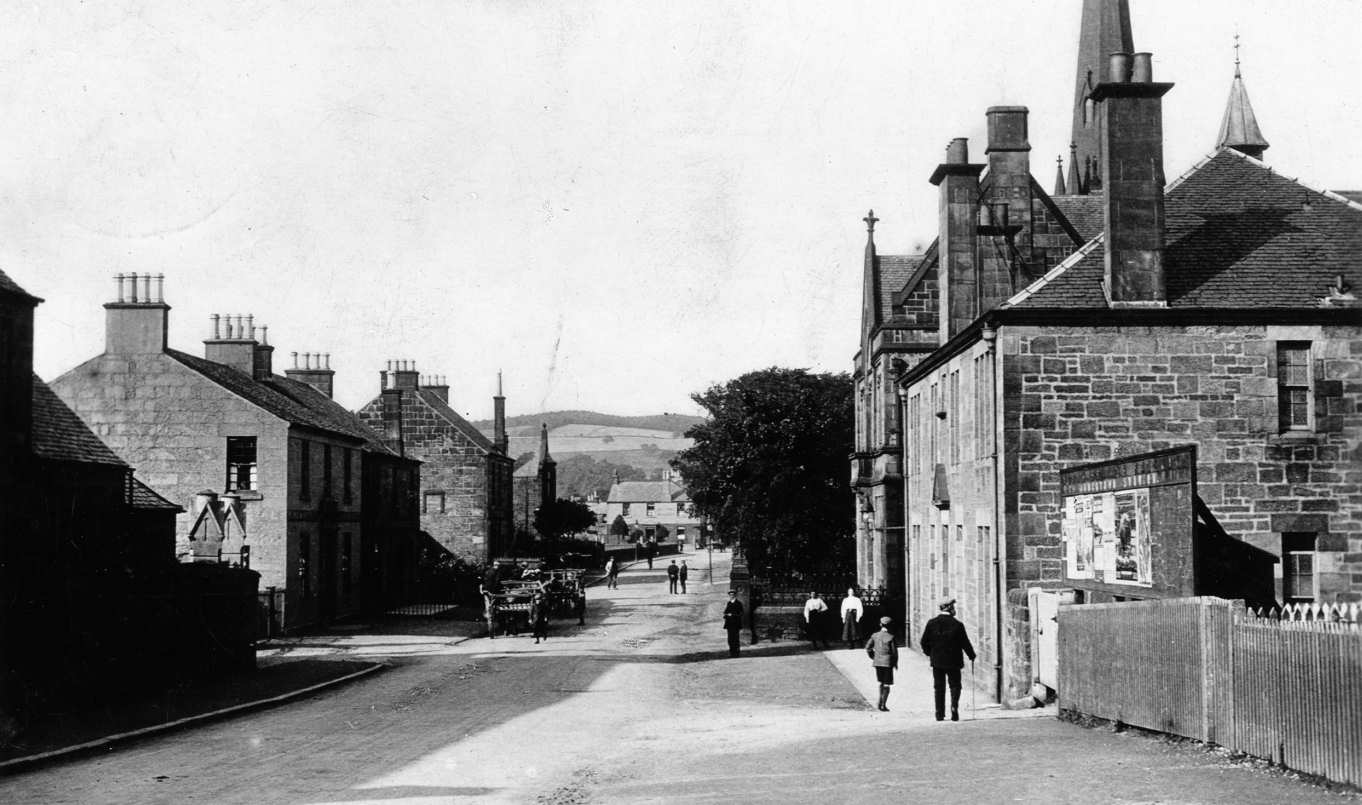
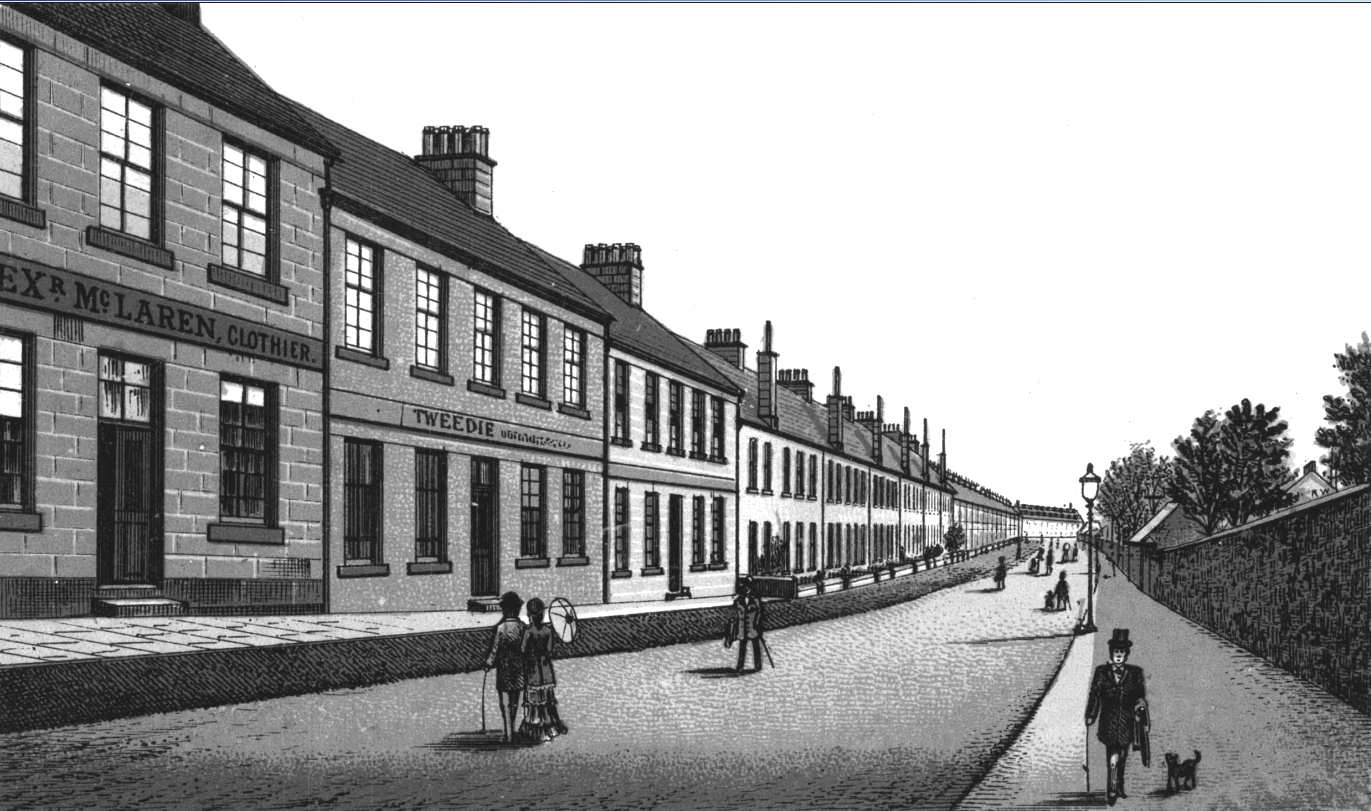
Jamestown Steet Scene (Click to Enlarge)
Long before the old dam was swept away, the hamlet just east of the mill had been given its first name, probably about 1750, and it was called Damhead, or more likely, Damheid, of Balloch. There are much worse names than that in Scotland, but obviously the hamlet's few residents were none too impressed and looked around for a snappier one. The story goes - and this is one urban myth that is probably true - that in the 1790's there were a number of men (3 is often mentioned) living there with the name James, so they decided to call it Jamestown, and Jamestown, or more usually, Jimson it has been ever since.
The second reason that the name Dalvait features prominently in the development of Jamestown is that it was on the land of Dalvait that the first houses in the area were built. These were fishermen's houses, belonging to the men referred to above, who drew nets across the Leven to catch salmon. Nothing new there you might think, but their operations were quite legal as well as very profitable. In the mists of time the Crown had given permission for nets to be drawn at specific locations on the Leven. These locations were called “shots” and were originally mainly held by churches.
After the Reformation, local landowners grabbed them in the mid 16th century, and they were rented out for the next 300 years or so. There were a number of them based on the riverbank around the Fisherwood, but since they could be worked from either bank, many of the fishermen lived at Dalvait. The hamlet straddled both sides of the Carrochan Burn as it entered the Leven. The original houses survived into the 19th century, but were gradually swallowed up by the expansion of Levenbank Works, particularly the major building work of the 1850's and 60's, and had completely disappeared by the 1890's, when netting was abandoned.
Some of the later buildings located on Dalvait Road close to the entrance to Lennoxbank House, and which probably housed fishermen displaced by the expansion of Levenbank, were occupied until the 1920's and their ruins were still evident after World War Two. However, when Damhead or Jamestown was established in the mid 18th century, the people of Dalvait were its largest single group of inhabitants, although that soon changed.
Jamestown Dam (Click to Enlarge)
Further proof of the importance of the area of Dalvait, is that one of the first of two Parochial school houses in Bonhill Parish was built at the “top” of Dalvait Road (i.e. Jamestown end) about 1772. The schoolhouse was a two-story building, consisting of a schoolroom on the ground floor and a house for the schoolmaster on the upper floor. A Statute of 1646 from the old Scottish Parliament had required a schoolhouse to be built in each Parish. It took the Heritors (which in reality meant those with money and land) of Bonhill Parish almost 130 years to comply with this Statute, but at least when they did, they had the good grace to build a schoolhouse on both sides of the Leven, because at the same time as this one was built at Jamestown, another was built on the Smollett's estate at Cameron. This is an indication that the centres of population in the 1770's, small as they were, were at the northern end of the valley.
The school was obviously one aspect of Jamestown's status at the time. Another was the fact that from 1809 until 1848, the minister of Bonhill Parish Church, still for all of that time the only Church of Scotland Church in the whole of the Vale, lived in a house at Mill of Balloch, close to the schoolhouse. A new Parish Church was built at Bonhill in 1747, and in 1758 a manse was added in front of the Church. When the Reverend William McGregor took charge in 1809, he declined to live in the manse probably because it was in a pretty dilapidated state, and lived instead over 2 miles away in Jamestown. He was a bit of an iconoclast both religiously and socially, and it is very unlikely that he cared much what his parishioners thought of this arrangement. It probably gave Jamestown some additional influence to have the minister in residence, and he stayed there until his death in 1848.
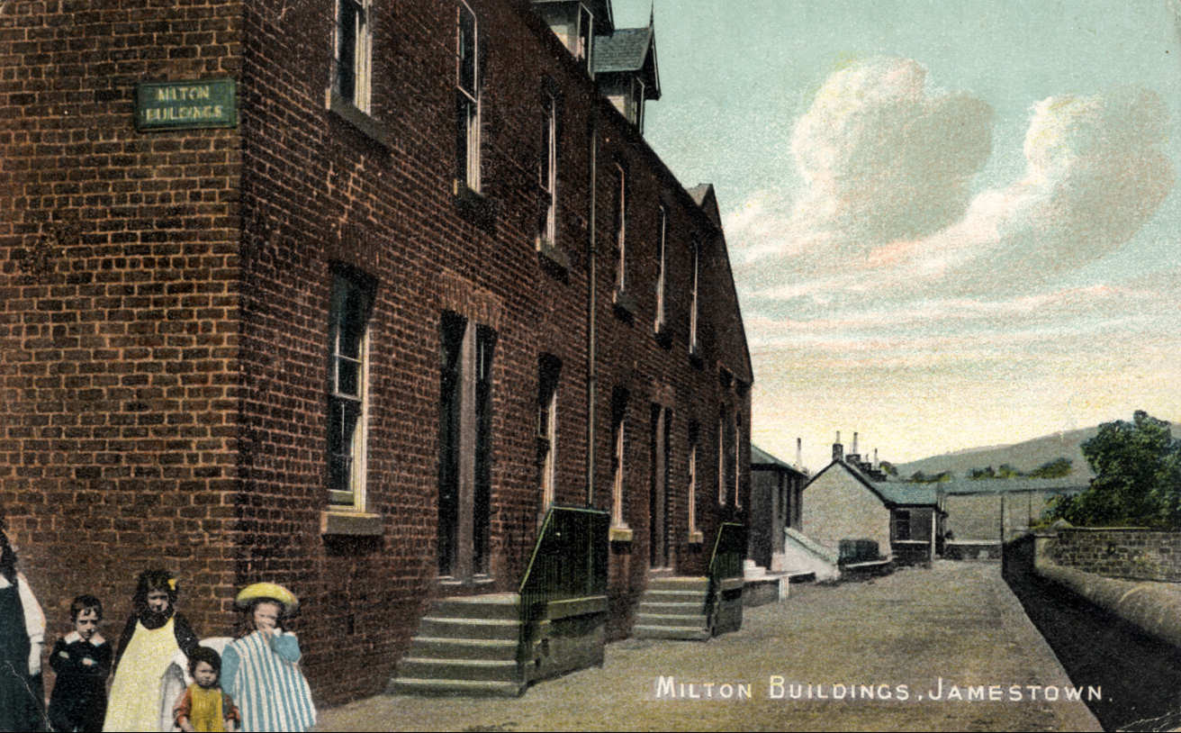
By the end of the 18th century, the fishermen and workers at the Mill of Balloch had been joined by people working in the two textile finishing works, which had opened at either end of the village. The first of these works to start was Milton, which opened in 1772 on the banks of the Leven as a bleach works. Todd & Shortridge, who had started Levenfield in 1768, directly across the Leven from Milton Works, owned it. Levenfield was the first block print works in the Vale, and Milton bleached the textiles, which were then printed across the river. It is not certain that it was actually called Milton to begin with. That name definitely was used from the 1850's onwards after it had been bought by Archibald Orr Ewing and expanded over the road to-wards Milton Farm. Its nickname of the “Leigh Field” or Low Field probably dates from the early 1800's when Levenbank Works started to be expanded by John Stuart.
Watson, Arthur & Co, opened Levenbank Works in 1784 for the printing of what we would now probably regard as women's accessories, such as shawls and handkerchiefs. In 1808, it was taken over by Stuart, Arthur & Co and modest expansion took place. But even in the late 1820's and early 1830's, James Barr who was born in 1816 in Dalvait, tells us that Levenbank print works "consisted of half a dozen buildings of not very imposing dimensions. Much of the rest of the ground now covered by huge brick extensions (Barr was writing in 1892 - 1893) was then open grassy fields."
At this time Levenbank was also known as Lennoxbank Works, while it also acquired the nick name of “Heigh Field” or High Field as opposed to the Low Field of Milton Works. Stuart seems to have had financial interest in the very first steamer on the Loch, the Marion, which started sailing in 1818. It was moored in the Lade of Levenbank Works over the winter. Many of the crew were also employed in Levenbank for the winter.
In 1825, Stuart built a fine new house for himself, Lennoxbank House, in Dalvait Road. In the course of building this house, the line of Dalvait Road, which, after crossing the Carrochan Burn, had previously run close to the river all the way to emerge on the Front of Balloch immediately opposite the Balloch Hotel, was altered to pass behind the new Lennoxbank House. The new line of the road has remained in place to this day.
Both of these works were, to begin with, very modest operations, probably employing no more than about 20 men each. The houses in which they lived were clustered north of Dalvait Road on both sides of the Dumbarton - Stirling military road (now Main Street). Nothing has survived of them, but until the late 1950's-early 1960's, which was after much of the Haldane had been built, a number of old 2 storey tenement buildings many, dating from the 1820's and 30's, still stood there on both sides of Main Street, Jamestown. Some would have replaced earlier buildings. Collectively, they defined the core of Old Jamestown.
On the west side of the Main Street from Dalvait Road north, was a group of separate buildings standing on what was known as Fenton's Land. Most of these old buildings were demolished in the late 1960's to make way for a car park and the row of retail units, which included a laundrette and a bar owned initially by Robert Dawson, Mister Robert's that changed hands a number of times. Subsequent names included Bunny's and it is now known as Fenton's Bar, presumably after Fenton's Land. (See discussion page entry on this)
The last of these buildings to be knocked down was the one housing the Lochiel Bar, which is now occupied by a block of flats. Elmtree House a few yards further west on Dalvait Road, which probably dated from about the 1850's / 60's, survives in isolation. At the north side of Fenton's Land, the Ben Lomond Garage was built by Joe Campbell in the late 1920's - early 1930's. The Elliott family later acquired it and added a general store to the garage and bus operation. Elliott's and the garage are long gone, with a convenience store now occupying the site.
Across the Main Street stood a row of 2-storey tenements dating from different times, but the ones which survived until the late 1950's / early 1960's were probably built in the 1820's and 1830's. Many pictures survive of Old Jamestown in the 1850's and 60's, and even now convey a strong impression of Jamestown as a rural village, rather than the industrial one that it was fast becoming.

A Wedding Scene taken Behind the Tenements in Jamestown in the 1890's with the Minister of Jamestown Parish Kirk in attendance. The wedding is of Wilhemina Weir to William Crawford of Dublin. (The groom was obviously conscious of his lack of inches. You can see that he is standing with his heels on the higher step above.) Also in the photograph are Agnes Weir and her husband George Manson, Margaret Weir and her husband William McLaren and Mary Weir and her husband Andrew Stewart. On the far right of the photo is Thomas McKean Weir and his wife Jeanie McLaren. The minister is the Rev. Daniel J. Miller of Jamestown Parish Church. The Victorian looking lady is Mary McKean, wife of Dugald Weir (then deceased) who was the proprietor of the Kind Man pub in Renton. (Click to Enlarge)
Certainly, in 1810, about 30 years after the two Works had opened, it is recorded that there were only two buildings between Dalvait Road and Bonhill. The first of these was a tenement building at Arthurston (not the present Arthurston House), in which employees of Levenbank Works lived. About 100 yards further south and on the west side of the road stood Levenbank House, the residence of Mr Arthur, one of the founder / owners of Levenbank Works, after whom the various roads, buildings etc with “Arthurston” in their names, were called.
Levenbank House was apparently one of the most attractive houses of the area for a time, but was badly damaged by fire, and lay derelict, after which it was called the “Burnt House” (Rantonians' easy penchant for a funny nickname obviously never quite reached 19th century Jamestown). The property was rescued by Archibald Orr Ewing in the 1850's. On the land previously occupied by the “Burnt House”, Levenbank Dairy was built. Levenbank Cottage was built a few yards further west on ground overlooking the Leven, and it became the Levenbank Works Manager's house. The Dairy was in use until Cameron's Dairies moved to the former Co-op Creamery in Dumbarton in the 1960's, while Levenbank Villa survived until the 1980's, when it was demolished to make way for the Levenbank Gardens development.
In 1843, the Disruption struck the Church of Scotland, with a large part of the membership leaving to form the breakaway Free Church of Scotland. Although there was as yet no Church in Jamestown, and although the minister of Bonhill Parish Church was still living in the village, and he stayed within the Church of Scotland, the split did have some impact on Jamestown. Unlike the established Church, which had taken over 130 years to build a parochial school in Bonhill parish, the new Free Church immediately built a Free Church School in Jamestown, where it still stands, now at the junction of Carrochan and Miller Roads, but then at the north end of the village. After it ceased to be a school, it was used for a variety of purposes including housing, as a Vale Academy FP Hall and a public house. It has proved a most durable survivor.
The 1840's and 50's were a time of great change in many other ways in Jamestown. Most of the changes were mutually supportive, and while some were fortuitous - e.g. the timing of the coming of the railway, just when the expansion of the factories required greatly increased transport capacity, others were very much planned e.g. the building of the Terraces to house the new workers required by the expanded factories.
 In 1845 Levenbank Works was acquired by Archibald Orr Ewing, who had just left his brother's company, which owned Levenfield Works. This was his first step in building what became a considerable textile finishing empire. Within a few years he completely transformed the works, steadily expanding it so that Levenbank Works eventually occupied more acres than the whole of the rest of Jamestown put together. A key aspect of that expansion was the construction of the three and four storey buildings that became characteristic of the Vale factories. Only one of these Levenbank buildings survives - as a block of flats. The expansion was considerable by any standards, and a great example of Victorian industrial competence and confidence. It was soon replicated at the other Vale factories.
About 5 years later, about 1850, Orr Ewing added Milton Works as his second factory. Until then Milton had lain only between the road and the river, but now it was expanded on the east side of the Jamestown - Bonhill road into what is now the Gilmour and Aitken timber yard. At the same time the existing riverside works was rebuilt. A tunnel under the Jamestown - Bonhill road connected the two parts of Milton Works, and after a railway branch line came into Milton Works in 1861, a line ran down through that tunnel to the riverside part of the Works. Into the 1950's it was still possible to go through that tunnel, but it was eventually boarded up and finally bricked up when the riverside walkway was laid out on the derelict works site in the 1980's.
The Forth & Clyde Junction Railway's Balloch - Stirling railway line came through the village and Jamestown Station opened for passenger and goods traffic in May 1856. Railway sidings not only went off into the adjacent Levenbank Works, but in 1861 a line was built into Milton Works, and it then branched off to continue round to Dalmonach Works, crossing the Bonhill - Jamestown road on a level crossing at Sandbank. While the Stirling line carried passengers, agricultural goods and cattle for all of its length, for the first 50 years or so of its operation, the industrial traffic such as coal and textiles on the Balloch - Jamestown section probably generated as much revenues as the rest of the line put together.
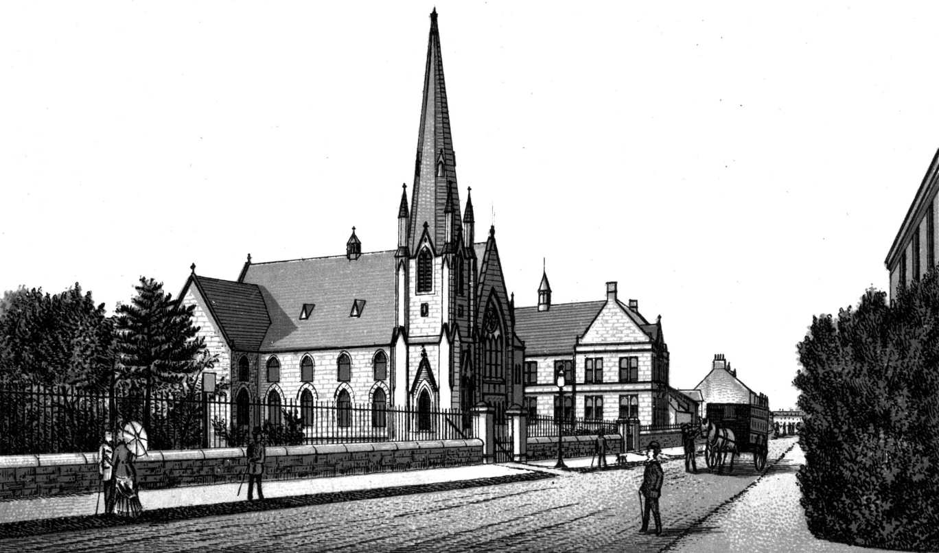
An old drawing of Jamestown Kirk, a view very still familiar today (Click to Enlarge)
Passenger traffic was also brisk at Jamestown, not only workers coming from the countryside to the textile works, but also on a Saturday country folk coming to do their shopping in the Vale. After trams were introduced from Alexandria Fountain to Jamestown Station in 1908, many country folk transferred at Jamestown from the train to the “Jimson Caur”, the “Jimsun Barrow” or “Jimson Bogie” - a lot of nicknames for only one tram - en route to the substantial shopping centre that Alexandria was at that time. The tramlines were not allowed to cross the railway line, so the terminus was a loop immediately to the south of the Jamestown level crossing. The upper deck of the tram was open, and because of the low railway bridge in Bank Street, passengers on the Jamestown tram could use only the lower deck, so it must have been pretty crowded at times.
 As with many rural railway lines, motorised transport killed the line's passenger business, and in
spite of innovations such as a steam rail-car, the line closed for passenger traffic in September 1934.
As with many rural railway lines, motorised transport killed the line's passenger business, and in
spite of innovations such as a steam rail-car, the line closed for passenger traffic in September 1934.
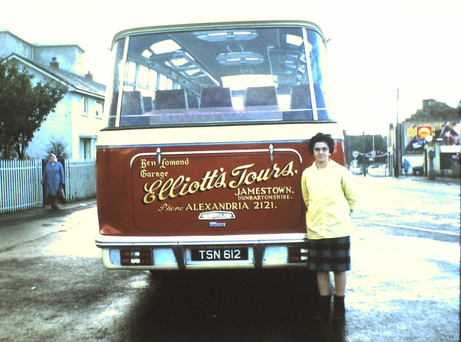
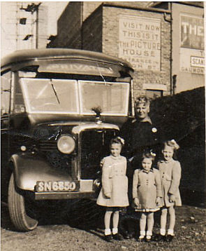
The motor car and bus had already killed off the Jimson Caur in 1928, the tram being replaced by a local Jamestown - Fountain service provided initially by Joe Campbell and then for many years by John Elliott's buses (Pictured).
This local service faced very stiff competition from the 132 and also after the Haldane had been built in the mid 1950’s, the 137 routes, operated by Central SMT, which from the 1930's to the 70's passed through Jamestown every 10 minutes. Elliott's bus called it a day in the early 1960's.
We are grateful to John Elliott's now exiled son, Colin who emailed us more information and pictures of his father and the bus. Colin reminded us that the proper name of the Elliott's garage was the Ben Lomond garage. The local bus service was via a bus called "The Pioneer". A humourous little poem (author unknown) was written about this bus service back in the 1930s (see right column).
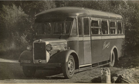
Elliott's Pioneer Bus (Text on the side of the bus reads Elliott's Pullman Service)
The station yard also housed bulk goods businesses such as coalmen and Gray's Grain Store, right up until its closure in 1964. The line was a busy goods route during the Second World War as an alternative route between the Clyde and the Forth. For a time it was thought of upgrading it to carry coal from the Stirlingshire and Fife coalfields to the planned new super gas works at Dumbarton, but nothing came of it, and the line was closed as a through freight line in August 1949. After that the line stayed open and in use between Jamestown and Croftamie, but was closed beyond Jamestown in 1959 and Jamestown – Balloch only survived another 5 years.
A goods train ran most days to Jamestown and 3 days a week to Croftamie, carrying bulk goods such as coal and agricultural supplies, as well as timber into the timber yard in the old Milton Works. This level of activity was not sustainable, and even without the Beeching Report the line would have closed, which it did in 1964. Within a few years the level crossing had been removed to return the road to its pre-1856 level, and a pedestrian path opened across the Stirling Bridge into Rosshead. The Council took over the former goods yard and a small industrial estate was built on it. This has housed many small businesses over the years, and is a resilient home for a number of small companies which have provided very welcome quality services and modest employment. To-day of course, there is much regret over the demise of the Stirling line and a recognition of the loss of a potential tourist and commuting boon.
For a short time after 1856 the railway line acted as a sort of unofficial southern boundary of the houses in the village. That didn't last long, though, because Orr Ewing greatly expanded factories were booming with much larger work forces that urgently needed somewhere to stay. Orr Ewing's answer was simple: he needed housing for his workers, and the quickest and most effective answer was to build the houses himself. So in 1864 he started to build what became known as the “Terraces”.
Jamestown Terraces (Click to Enlarge)
Starting on the east side of the Jamestown - Bonhill road immediately adjacent to Jamestown Station he worked south. His first building was initially called Ewing Terrace, but it went by the nickname “Piano Terrace” because it was assumed that everyone who was lucky enough to be able to rent a house in Ewing Terrace could also afford to buy a piano. By 1867 the Terraces had dramatically expanded with the completion of Levenbank (which incorporated Ewing Terrace) and Milton Terraces southwards along the Bonhill - Jamestown road. In 1874, the building of Napierston Terrace completed the Terraces.
Napierston Terrace actually consisted of two buildings, one in Auchincarroch Road (“the Side Block” and a much shorter one on Main Street (“the Front Block”). The Terraces defined Jamestown for a century, both in appearance and terminology. No one referred to “Main Street Jamestown”; it was just “The Terraces”, indeed most people still do when referring to that part of the road. Also, like Back Street Renton or the Burn Bonhill, every family in the Vale seemed to have a parent or grandparent who came from the Terraces.
The front block of Napierston Terrace strung with
bunting. We do not have a
date for this picture but it may
be from the King George VI coronation in 1937.
The Terraces and the two works were overwhelming evidence that Jamestown was a company village - or by 1900 when its population had grown to well over 2,000, a company town. Like many Victorian industrialists, Orr Ewing had a strong paternalistic streak, which became even stronger after he became the Unionist or Conservative MP for Dunbartonshire from 1868 - 92. Because of the various Reform Acts during these years, and the widening of the franchise amongst adult men, Orr Ewing needed not just the labours of his employees, but increasingly he also needed their votes. In Jamestown, at least, he proved worthy of the challenge, with his money paying a large part - in some cases all - of the many new public buildings, which now started to appear.
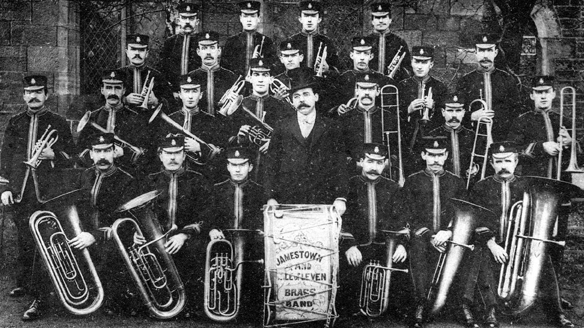
Jamestown and Vale of Leven Brass Band was founded as a flute band on temperance principles in 1872 by the headmaster of the Free School, John McNidder and William Munro. Thanks to the generosity of Orr Ewing, Alexander Smollett and others, they obtained their first set of instruments in 1877 and were successful in competitions around the country. Under their first resident conductor, Mr. Shaw, pictured with the band, they further improved but ran into financial difficulties in the early 1900s. The band appears to have been reconstituted after the first world war and finally disbanded about 1931
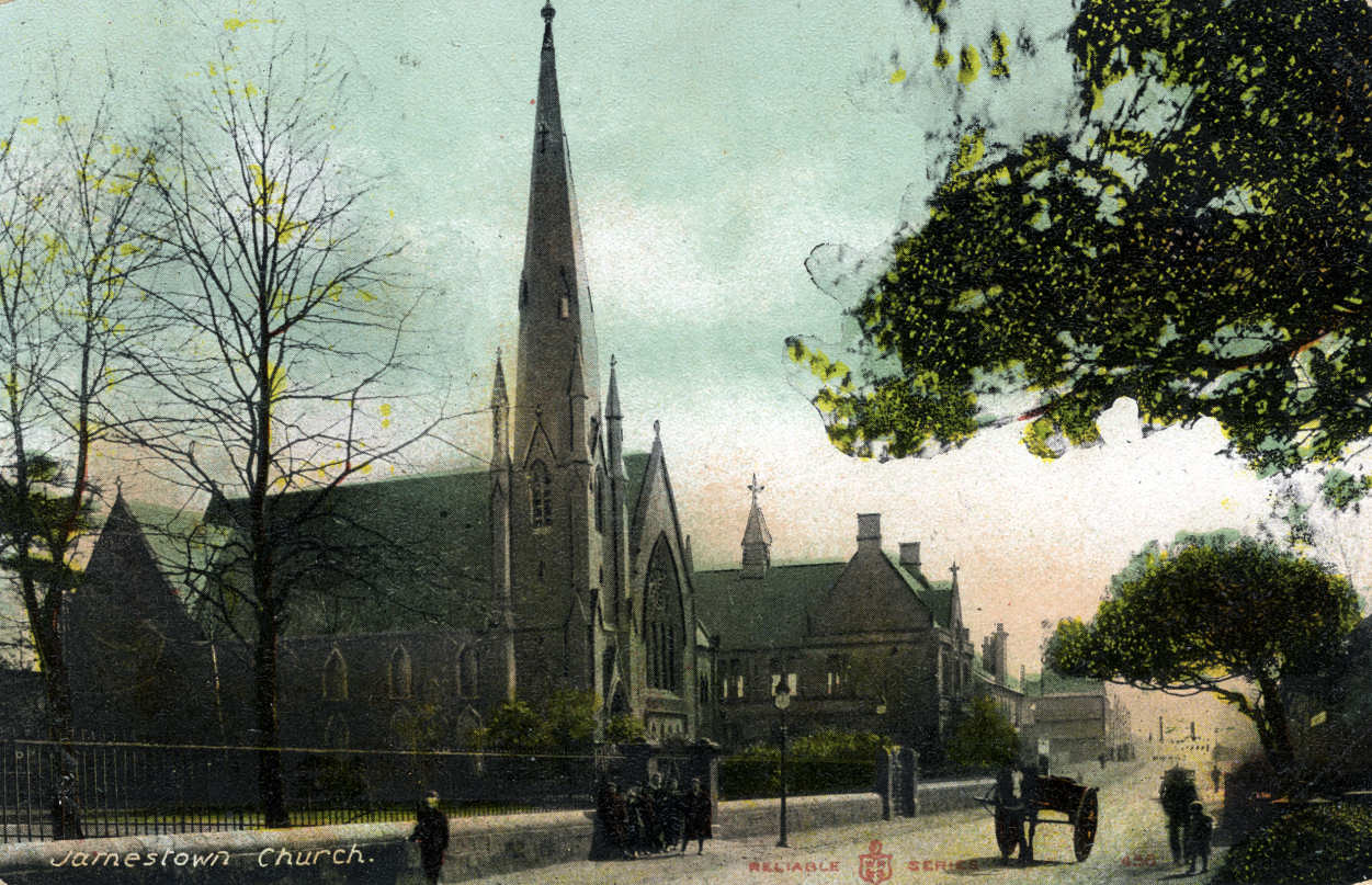
Orr Ewing probably didn't fund the parish school, which was built in 1856 to replace the 1771 schoolhouse. This was built on the site of the present Jamestown Primary School and can be seen as a belated response to the Free Church School just a few yards up the road. However, when the present Jamestown Primary School was built about 1874, Sir Archibald did chip in. As he did when Jamestown Parish Church was built in 1869. He paid for Arthurston Hall, which was built as the village hall in 1884, and later became the Church Hall.
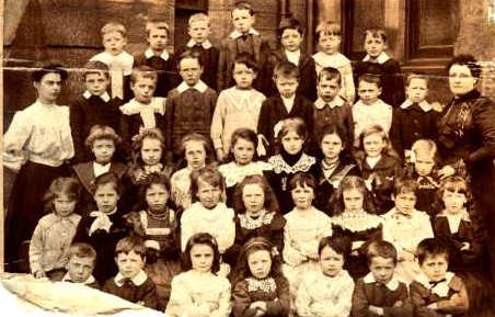
Jamestown School about 1900
These were all fine red sandstone buildings, which greatly enhanced the appearance of the centre of the village, and equally greatly added to the quality of life of Jamestown residents. He couldn't resist one further burst of more direct self-interest - he paid for Conservative Party Clubrooms on a site immediately adjoining the southwest side of the railway level crossing. These Clubrooms long outlasted any overt Conservative presence in Jamestown, and actually provided a useful social venue until the early 1960's. Strangely, at a time when every spare square inch of land in the Vale is being built upon, the site of the former Conservative Clubrooms lies derelict, neglected and apparently unwanted.
From the 1850's onwards the centre of the village saw a steady procession of changes. The first of these had perhaps the greatest visual impact, dominating the views of the centre of Jamestown for the next 100 years - the building of the new Mill Dam at the corner of Main Street and Dalvait road in the early 1850's. The new dam's feeder system ran from the Carrochan Burn close to the chemical factory known as the Chip Factory, because it extracted chemicals from wood, for use in the textile dyeing process. The Chip Factory has been closed for over 100 years, but many people still refer to the general area on which it stood beside the Carrochan Burn by that name.
A man-made burn that ran close to the railway line fed the dam. Since it fed water into the dam, this burn was known as “the Inlet”, but the pronunciation was soon corrupted into “the Inler”. The term Inler has stuck for the track and area behind the school and church. The Mill of Balloch stopped grinding grain about the end of World War One, and although the Mill wheel was occasionally turned right up until about 1950, Jamestown Dam was effectively redundant from about 1919.
For the last 30 years of its life, the Dam was by no means the picturesque village pond of many photographs. It was a stagnant dump, and particularly in the summer, it must have posed a public health hazard, not just for its overpowering stench, perhaps the last obvious one in the Vale. Its only upside was that in cold winters it froze over and served as a skating rink, where many a local child learned to skate, and where ice-hockey thrived in the centre of Jamestown. When it was bought, drained and filled in by Pop Robson in the 1950's, there was universal relief and delight amongst locals. The petrol station, which he built, still occupies the site, albeit rebuilt a few times under different owners.
Most of the buildings in Jamestown, which housed shops, date from the 1860's onwards. With a single exception, (a shop in Elmtree Villa in Dalvait Road) all of the shops in Jamestown were either in the Terraces or on Main Street. Archie Aitken in his excellent book “Jamestown and Balloch as I Remember Them” lists Jamestown's shops in the 1920-30's: There were three shops in the Short block of Napierston Terrace; two in Milton Terrace, one on the southern corner, the other stood all on its own in a separate block between Milton and Levenbank Terraces was called Milton Stores, but will be remembered by many as Davidson's Stores.
In Levenbank Terrace there were another two shops, one of which housed the Post Office. There was also for many years until the late 1950's, a single constable Police Station in one of the houses of Old Levenbank Terrace. The first retail premises on the west side of Main Street were north of the level crossing. Firstly, was one of the two villages pubs, right beside the main entrance to Levenbank Works, the Rowantree Bar, but better known as Smith's after owner Neilly Smith (who died in the mid 1950's), and then his son Jimmy. Adjacent to that, was a Co-op property dating from 1894, which had two shops with houses upstairs. Although the Co-op is long gone, this building still stands and houses a hairdresser's shop.
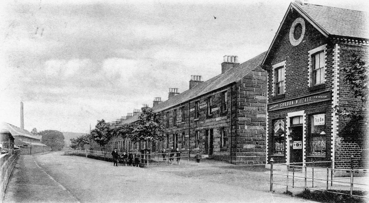
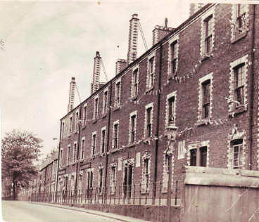
Levenbank Terrace (Click to Enlarge)
A few yards further north, is another former Co-op property, which the Co-op acquired in 1879, which was Co-op grocers, but hasn't been used as a shop for some time. Nor has another ex-shop building just along from it which was bought by Miss Mason in the 1950's when the Mason family sold the Loch Lomond Hotel to Ma Barton. Miss Mason ran it as a wool shop for many years.
Across the road, and still going north, just north of the school, two villas survive from the late 19th century, altered for retail use, but still quite recognisable as Victorian villas. To the rear of the first villa, and on the site of the old Plantation, an Italian restaurant was built in the 1960's. It has had a number of roles including time as Whitelaw's American Diner, and is now Chimes Chinese Restaurant.
On the adjacent property, part of the villa of Annfield was for many years a fish and chip shop belonging to the local Palombo family. This is still being used as a fast food outlet but iit has changed ownership several times. Across Burnside Crescent from Annfield there was a lean-to building, which had been a barbers, but by the 1950's and 60's was Good's general store and confectioners. In the old row of two storey tenements on the east side of Main Street, dating back to the 1840's or so, which had probably replaced even earlier buildings, a chip shop was opened in the mid 1950's to service the new houses in the Haldane. It was when these tenements were demolished in the 1960's that the Annfield fish and chip shop was opened to replace it.
Just beyond the tenements and across the road from Elliot's garage was an empty piece of land on which a small wooden pavilion had been erected for the Clarion Cycle club. In the winter the Harriers also used it as their base for cross-country running, being nearer open country than Millburn Park.
In the early 1900's, a Golf Course opened at the north end of Jamestown. It ran in a north-westerly direction from about the Free Church School, and covered the area from there to about where Lomond Road now is, with Dalvait Road as its western boundary, and Carrochan Burn as its eastern one, although it did cross the Burn in places. Few details of the Course have survived, but given the area that it covered, it could not have been an eighteen-hole course. It didn't have much luck with its location, because the land seemed to be needed for other uses, and the Golf Club lost out. Firstly, Carrochan Road cut across the Course, and while that could be worked round the next demand proved fatal for the Course.
As war approached, the land between Carrochan, Dalvait and Lomond Roads was acquired for military use. In fact this consisted of building houses to accommodate key workers in the war effort - something of a throwback to the Admiralty Huts at Levenvale in the First World War. Instead of being called “The Huts Two”, they were called The Hostels. There is little recollection of the Hostels use during the War in the local collective memory. However, their post-war use is well remembered.
Immediately after the war, the Hostels on the Jamestown side of the Carrochan Burn were used to relieve the local housing shortage, and many local families lived there for many years - most until the new houses in the Haldane became available about 1954. After that, the Jamestown Hostels received the council's more difficult tenants, of whom the redoubtable Teenie Black was perhaps the best known. This was something of a controversial policy and was seen as “dumping”, a term which, then as now, was unpopular and widely regarded as offensive for a whole variety of reasons depending on who you were. There was general relief all round when it was decided to build a new small housing estate - the Carrochan Estate - and a new Roman Catholic Primary School, St Kessog's, on the site. All of this was done in the mid to late 1960's.
As well as the Golf Course, there was a Levenbank Works tennis court and bowling green on land behind the Dam, which backed onto the Levenbank Works stables. Both of these were for employees of Levenbank Works, but both continued in use for a while after the closure of the Works. The bowling green became the Jamestown Veterans Bowling Club for a time. The tennis court survived until the 1960's but like every other court in the Vale, it succumbed to either the general decline in the popularity of tennis or the attraction of land for development. Both court and green were eventually built on and private houses now occupy the sites.
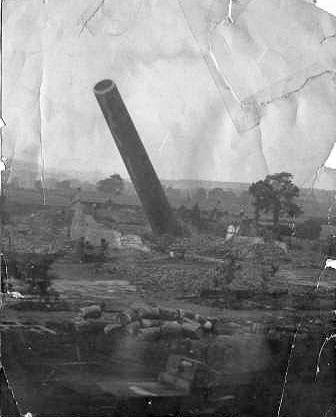
This is the photograph of the demolition of one of the chimneys at Milton Upper Works, Jamestown. We’re not quite sure just how many chimneys there were in the Upper Works, but there were at least two, and the top of this chimney, which was located in the north east corner of the Works, is landing more or less where another one had stood, at the south-west corner.
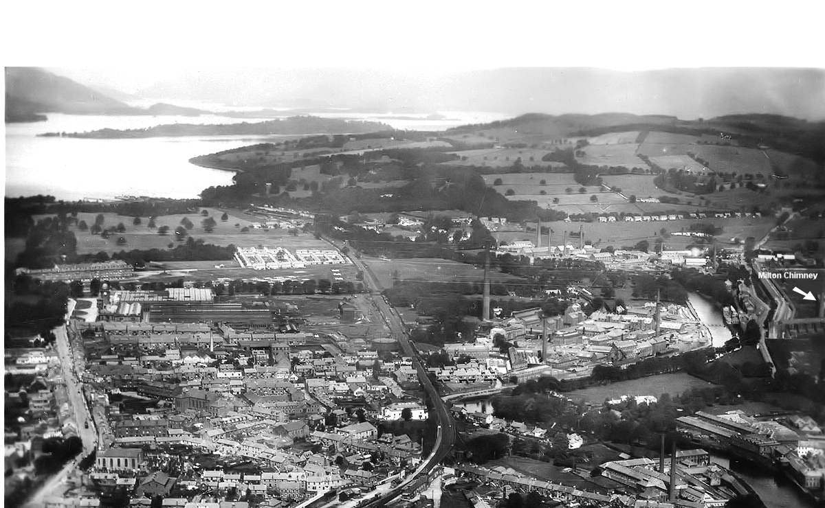
It seems likely that some of the brick rubble in the photograph are bricks from the second chimney which had obviously been demolished prior to the one in the picture. This second chimney appears in 2 of the accompanying photographs. In the first one, which is an aerial photograph of the Vale taken in the 1920’s, and which has been supplied by Graham Lappin, you can just make out the chimney in the extreme right hand side of the enlarged photo in deep shadow.
Click to EnlargeIn the second photo, which appeared in the book ”The Vale Then & Now” by Arthur Jones and Graham Hopner, it is the right hand of the two chimneys – the other is actually across the Leven in the Craft, although it is definitely not the Craft Stalk.
Click to EnlargeAt 180 ft the falling chimney was one of the highest in thearea. The demolition took place on the afternoon of Wednesday 14th February 1934 and the work was carried out by Messrs Baird Brothers of Port Glasgow. The Works had completely closed in 1919 and by the end of the 1930’s Tommy Anderson’s sawmills had occupied the site; it is now Gilmour & Aitken’s woodyard. Because of its height, the chimney is having to fall diagonally across the demolished Works to-wards the west end of Napierston Terrace and along the back of Milton Terrace. The china must have rattled in the Terraces when that came down.
The photo was taken by Jimmy Russell and from the height and angle it looks as if he was in a 2nd or 3rd storey window in Napierston Terrace. For the time, its a wonderful piece of photography. In the far background are Milton Cottages which look more or less exactly as they do to-day.The puzzle is, what was making it fall? There doesn't seem to be an explosion - probably too close to the Terraces anyway - and no smoke from a fire, which was one of Fred Dibnah's preferred methods. So what brought it down? Hopefully, it should get some discussion going?

The early 20th century was the harbinger of things to come for the Vale's textile industry. A combination of cheaper competition in the Far East and an industrial recession saw cut backs from about 1909 onwards. In 1911, sections of Milton Works were closed down, and the Works completely closed in 1919. The riverside buildings were demolished soon after and that part of the Works lay derelict for the next 60 years. The only visible evidence at road level that there once had been a works there was the high wall dating from the 1850's which ran the whole length of the site from Auchincarroch Road in the south, to the Conservative Clubrooms at the level crossing in the north - always allowing for a few openings for gates into the Works and houses. Large parts of the wall have survived, although its height was considerably reduced when the old Milton riverside site was landscaped in the 1980's and a pathway laid through it.
There were a few houses behind the wall. Furthest south was Milton Villa, originally the manager's house for Milton Works. The Scout Hall from the 1960's stood more or less on the site of the Villa. About 100 yards north from that was the entrance to both Levenbank Villa and Levenbank Dairy mentioned above. Most of this area is now occupied by Levenbank Gardens, a small private housing estate.
Levenbank Works lasted a bit longer than Milton, but with a steadily decreasing output. It was closed as a textile works by 1939, when it became an Admiralty Victualling Store for the duration of the War. After the war, for some years it housed many smaller companies such as Franco Signs, Wallcraft Paint, Leddy & Glen and Wellowear. It also housed a local cattle market, which proved very convenient to both local farmers and butchers.
Its final occupants were Jamestown Concrete, which thrived for many years supplying building materials, paving slabs, etc. to both retail customers and local builders, and Kunz Engineering a light engineering and metal work company. By the early 1990's both had closed and the site was given over to housing. Honeysuckle Lane and Bramblehedge Path, which are accessed via the old front entrance to the works on Main Street, Jamestown, now occupy the major part of the site.
In spite of the closure of both Works, the overall appearance of Jamestown Street changed little in the years 1875 - 1955, apart perhaps from the “temporary” huts erected in the school playground to cope with the increased school roll of children from the new post-war Dalmonach housing estate. However, appearances were a bit deceptive. By the 1950's, the conditions in the Terraces, particularly Milton and Napierston Terraces, had declined, with many accusations in the 1950's of mismanagement and sharp practice by the landlords.
While the Terraces provided starter homes for many young couples including many from Glasgow, at a time of great shortage, they were also “sold” to some pretty anti-social residents. Milton and Napierston Terraces came to be regarded as undesirable places to stay. Also, the overall fabric of Milton and Napierston Terraces was no longer up to modern standards, and it was generally agreed that these two Terraces were coming to the end of their habitable lives. Levenbank Terrace had been built to a higher standard and there was a feeling that it should be refurbished, as Glasgow had already begun to do with many of its red sandstone terraces.
In the event, Milton and Napierston Terraces were demolished at about the same time in 1964. The council houses of Milton Estate quickly replaced Milton Terrace, while detached private houses were built on the former site of Napierston Terrace. The fine red sandstone buildings of Levenbank Terrace did survive for another 10 years, but even they succumbed and were demolished in 1974. The site then lay empty for about 20 years before a new private housing estate, also called Levenbank Terrace, was built on it.
The building of the Haldane from about 1954 onwards initially brought only benefits to Jamestown. The various shops and pubs in the village were much busier, the church gained new members, new recreational organisations were started, and the school was full to overflowing with even more huts added to the playground. A new pub was opened by Tommy O'Hara on Carrochan Road, and it had a licensed function suite, and a new fish and chip shop was opened about the centre of the old tenement houses on the east side of north Main Street. However, the continued expansion of the Haldane housing estate saw Woodburn Avenue cross the Carrochan Burn into what had until then been the beginning of the Inler, and therefore into Jamestown. It made sense to create a new access road to Woodburn Avenue and the Haldane, which is why Davidson Road was built. The downside to this for Jamestown was that all of the tenements on the east side of Main Street from Burnside Crescent northwards had to be demolished to make way for Davidson Road. Most of the tenements in Burnside Crescent were also demolished, and by the mid 1960's the core of Old Jamestown was no more.
However, Jamestown has proved adept at bouncing back, and even now new houses continue to appear - the latest on the former site of where this story started, the Mill of Balloch in Dalvait Road. In spite of encroachments, unintentional and otherwise, Jamestown will be around for a very long time yet.
Supplementary Page - A Brief History of Jamestown School from 1865 – 1935 >
![]()