Aerial Photos of the Vale - June 1947
Introduction
The Ordnance Survey organisation was slow to use aerial photography to map Great Britain. In fact, it was not until 1945 that an Air Photo Division was established in Ordnance Survey, using surplus RAF equipment and staff. Of course by this time RAF aerial photography was arguably the best in the world. It had proved itself in all theatres during WW2 when it had taken million of photos. In 1944 the RAF turned its attention to capturing photographic images of Great Britain itself, which it did between 1944 – 1950 in an undertaking called Project Review.
Project Review flew 500 sorties over Scotland concentrating on the more urban areas which had a requirement for post-war development and redevelopment. The planes used were mainly Spitfires and Mosquitos - ideal for unarmed high speed and high altitude reconnaissance over occupied Europe, but considerable overkill for the job on hand where slower less sophisticated planes would have been better suited. The cameras were state-of-the art F24 and Fairchild 17 cameras, and the pilots were highly skilled RAF reconnaissance pilots.
The project was a great success – perhaps too good as we shall see – and OS decided to publish over 200 mosaics of photographs from the sorties as a stop-gap until conventional surveying and mapping could be carried out. The photographic survey took on the short-hand name of the “Mosaics photographs” since together they built up a mosaic image of the countryside. Initially they were put on sale to the public between 1945 -47, but demand was poor. Also, and more importantly, security concerns arose about just what a powerful tool had been produced.
As early as 1950 doctored Mosaics were being issued which airbrushed over military sites, and by 1951 libraries were asked to withdraw the original Mosaic photographs, while by 1954 even the doctored ones were withdrawn from sale altogether.
It is only in the last few months that they have become available again to the public at large and even at that only on a couple of web-sites: http://maps.nls.uk/os/air-photos/ (where selected photographs can be viewed) and also at https://ncap.org.uk/search/keywords/bonhill.
Notes on the photography
The Mosaic photographs which follow have been in the possession of Dumbarton Library for some time and we are grateful to Graham Hopner for allowing them to be made available on the web-site. All of the 14 photographs were taken in a few minutes on 16th June 1947. The track of the plane that day was from south to north on the west side of the Leven with a few minor course adjustments on the way - the banking for which shows up on one of the photos.
When he got to Drumkinnon Bay he seems to have swung round and tracked south onto the east side of the Leven. He took the photos by pressing a button and since his 4 cameras (2 under each wing) were set to take stereoscopic photos i.e. 2 images quite close together on each wing or varying them to photograph in two directions more or less simultaneously, he probably pressed the button no more than 3 or 4 times over the Vale that day, the first one being over Place of Bonhill going north and the last over Linnbrain Hole heading south.
The taking of the photos can be grouped into no more than 3 or 4 locations, but apart from photographs 1 and 2 and 7 and 8, they do not appear in the order in which they were taken. That doesn’t really matter since it is the contents of the photographs which are of interest to us.
Apologies to Renton and Bonhill folk, but either the pilot did not take photos while over each town or they have been lost, and now there are no close-up shots of either place. The same is almost true of Balloch and Jamestown, but a number of buildings of interest, which have since disappeared, do appear in the distance in some of the photos.
Alexandria, however, is very well served by the photos and practically every building in the town has been captured in one photograph or another. The overall impression is of how many buildings were packed into the centre of Alexandria in 1947. Many buildings and places, long lost, re-emerge in these photos and many questions can be accurately answered such as, where was Castle Danger or where was Tooraladdie Lane, or what did the Northern Halls look like? A short commentary accompanies each of the 14 photos which hopefully will help readers to identify places and bring a few memories back. Hopefully, too, the photos will prompt readers to contribute corrections, stories and additional information.
The Images and Commentary
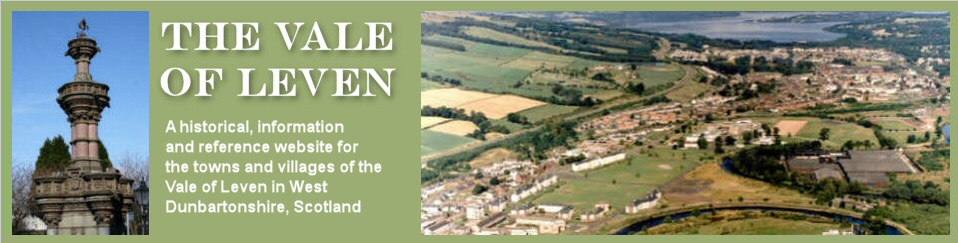
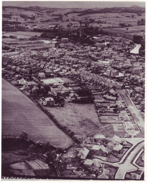
Photo 1 taken over Place of Bonhill and looking north-west.

Note the traces of photo identification at the bottom of the image. Places of interest include;
- In the bottom right hand corner, surrounded by trees, Place of Bonhill House, which recently appeared in the series of photos about the Pyroligneous Works on this site. St Martin’s Primary School now stands close by.
- Just beyond the House is the very large field in which the Vale of Leven Academy in its two forms has stood since the early 1960s.
- Main Street is coming up the hill past Allan Crescent on the left and as it crosses the railway line the two entrances into the Burnbrae Estate, now both closed off to the Main Street, are quite clear although a bus is sitting across one. Notice how empty the streets are of traffic and of parked cars.
- Continuing further along Main Street is the back of Millburn Terrace – one of the finest residential buildings to be lost to the new town centre road system – and the English Church immediately opposite it which allows us to still accurately place the Terrace’s location. Across the gap site is Vale Co-op’s Millburn Grocery, now David Graham’s car showroom.
- Just below Millburn grocery and slightly to the right there is a good view of the south end of Victoria Street with Jock’s Park the piece of vacant ground right at the end
- Going further up the photograph, there is a field where Queensway now is.
- Further to the right is Bridge Street Church, now gone and with detached houses on the site, and diagonally above it to the right, in Upper Smollett Street is the tennis club and its tennis court, now with 2 houses on it.
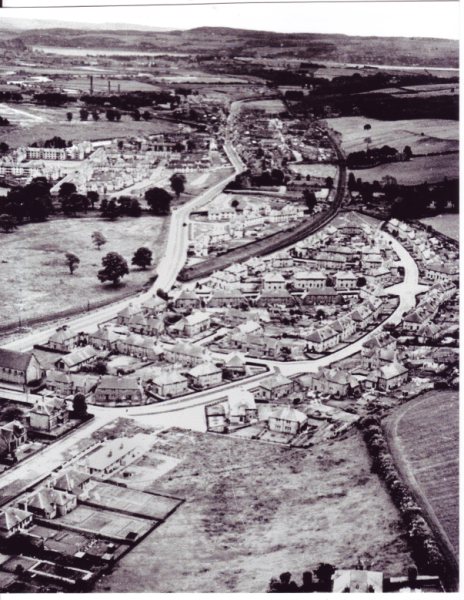
Photograph 2 – probably the stereoscopic image of Photo 1, and covers almost the same territory from a few yards further on, looking north-west.
Points of interest.
- While the Balloch bound bus has not moved from Photo 1, the Glasgow bound one has emerged from behind Millburn Terrace (you can just make out its nose in Photo 1).
- On the railway line in the foreground, the line going off into the east goods yard at Alexandria Station and also round to Dillichip Works via the Black Bridge can be seen clearly. Also note that this is about 10 years before they even started to electrify the railway so there are no overhead wires and gantries on the railway
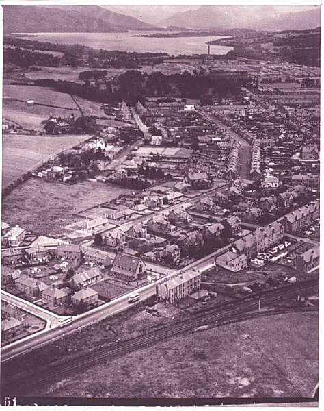
Photograph 3 – taken more or less over what was then the Vale Academy and is now Christie Park Primary School, looking south.

The plane had banked slightly to change onto a direct northerly course from the north-west one it was on, and that shows up in the angle of the photo. The photo is taken in a southerly direction and shows amongst other places:
- In the lower right the Masonic Temple at the junction of Gilmour and Smollett Streets, with the large piece of ground behind it clearly visible. That ground included a bowling green at one time, the site of which is occupied now by a bungalow.
- On the other side of Gilmour Street just to the left of the Masonic Temple is a yard belonging to Paton the Builders, complete with a lorry in the yard and a car parked outside.
- There are excellent views along Middleton Street and a strong impression of the “Z” which Main Street then took as it headed to-wards Renton down past Allan Crescent and up again past Millburn Church to turn yet again at the bottom of Cardross Road.
- The large square in the middle of Cordale is very clear and the tenement blocks along the Main Street at the front of the Cordale Estate have yet to be built. Unlike nearly everything else in Cordale in this photo, these tenements are still standing although much enhanced.
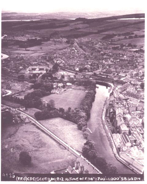
Photograph 4 – the first one from the east of the Leven, taken almost above Linnbrain Hole from the Dalmonach side, looking south.
This is probably slightly out of sequence since the plane is probably heading south by then. There is a treasure trove of images in this photo and this is a by no means complete list of items of interest:
- In the foreground are the houses along the Leven’s west bank and Ferry Loan. Ferry Loan is still there and was at that time a busy short cut between Bank Street and the tow-path for workers heading to the Craft gate.
- On Ferry Loan the large-ish building still stands, it is the Children’s Nursery then run by Dunbarton County Council
- Immediately opposite the Bank Street entrance to Ferry Loan is the Station Bar. Note its entrance is still on street level.
- In the railway station a steam train is stopped on the Balloch line. It’s a short goods train and is probably shunting wagons into the adjacent goods sidings. There is an even clearer view of this in a later photo.
Heading under the railway and north-west up Bank Street, the buildings on the east side of the Street with their backs to the camera are:
- The former Post Office (now a dental surgery) with its extensive sorting office for the Vale and country areas such as Luss and Gartocharn. The sorting office has been demolished and the site is a car park
- The Constitution Club building, still standing but not with that name
- The County Council Health clinic, demolished
- The Strand Cinema, demolished
- Two fine mansions which stand close to what is now Aldi
- A tenement building with shops such as Peter Ewing ironmongers and Babtie & Campbell, chemists
Back on the west side of Bank Street just to the right of the railway line and bridge are a row of shops which include
- Oliver’s’ Hosiery Factory and the Alexandria Telephone Exchange above it.
- The building easily identified by the arch in a white facing is the fabled Di Felice’s Cafe
- Next to it is the Clydesdale Bank about which there were the strongest architectural protests when it was demolished to make way for redevelopment in the early 1970’s
- Then Alexandria North Church. Its congregation moved to a new church in Balloch in the early 1960’s and it was demolished before redevelopment started.
- Willie Edwards drapers shop and Muir’s newsagents
- About one third of the frontage of the Co-op Halls
- In Mitchell Street is the back of Argyll Terrace, another fine building which was an unnecessary victim of redevelopment
- Running parallel to Bank Street one up is Random Street and what a rabbit warren that is. In 1947 there were few gaps in Random Street, but within a few years many of its older buildings had gone and the Street had many gap sites in its last 15 or so years. It was demolished in the early 1970’s and is now part of the Mitchell Way shops and car park
- There is a good view of John Street, which runs from Bank Street parallel to the railway on its west side right round to Victoria Street on a line not dissimilar from the new town centre road which replaced it
- At the junction of John Street and Random Street are firstly the Pawn shop (nearest to the bottom of the picture) and immediately across Random Street from it, Jack’s Railway Tavern in the single story building.
- Notice how much ground is taken up by the goods yard on the John Street side of the railway and the huts in the yard. The area is about the same as taken by the present car park used by the Shows when they visit.
- Church Street ran from John Street right up to Main Street, and the Church Hall is clearly visible about two thirds of the way up the street.
- The large shed behind it with the steeply sloping roof is part of Johnny Bain’s garage in Bridge Street
- Still on John Street but behind the building on the Bridge St / John St junction is Joe Proctor’s yard which backed onto the railway line.
- To-wards the top of the picture and immediately above Burnbrae is Millburn Farm, popularly known as Bauchop’s Farm, but by this time Jock Graham was the farmer.
- Beyond that farm is the road up to Carman Hill with the two Renton Manses on one side of the road and McLaughlin’s Farm on the other.
- On the top right corner is Renton Dam, while on the top left is a glimpse of the Clyde.
Photograph 5 – taken above the Masonic Temple looking north.

There are a lot of fields, woods and open spaces in this photo which looks right up the Loch, but some points of interest are:
- In the foreground, what was in 1947 the Vale Academy and is now Christie Park Primary School. Beyond it is Park Street where there are as yet no School Annexes on it. These Annexes must have been built in the late 1940’s / early 1950’s and are still standing. They are used by the Veterans and other Voluntary organisations
- The old pavilion in the Bowling Green, which backed onto Middleton Street
- Just beyond the Christie Park is a very clear view of the south drive up to Tullichewan Castle and beyond (or above) that is the Brock Hospital, popularly known as Broomley or Bromley (both spellings appear at different times)
- To the right of Bromley are the Maycrete temporary houses at the top of Heather Avenue on a site now occupied by the Swimming Pool
Photograph 6 – taken above the south end of Upper Smollett Street looking north-west.
There are a lot of places of interest in this picture including:
- Lower foreground the tennis clubhouse and tennis court in Upper Smollett Street. There are now a couple of houses on this site.
- Excellent view of the villas and gardens in Smollett and Middleton Streets
- Back view of Main Street School
- To its left, view of the corner of the front of Argyll Terrace in Mitchell Street and immediately behind it the Co-op stables and garages and then a back view of the whole of the Co-op Halls
- Going back along Main Street to Hill Street, a good view of the tenement called Castle Danger on the north corner of Hill and Main Streets. It is now part of Glen’s garage. Directly across Main Street is McKenzie’s pub, which of course is still there.
- Just above Castle Danger is the back of the building which housed the Green Oak ship shop, which is adjacent to the Bowling Club
- Further along Main Street, at the corner of Wilson Street and opposite the entrance to the Christie Park are the 3 Co-op shops which have had various occupants since but are now Sizzlers takeaway.
- To the right of these shops down at the bottom of Wilson Street is the Lennox Foundry much of whose facade still stands. On either side of the Foundry are the gasworks’ two gasometers. Note the railway siding which carried coal into the gasworks. Note, too, the 2 wee white cottages beside the right hand gasometer.
- To the left of the larger gasometer lies an almost complete view of the Torpedo factory and beyond is the Argyll Park and to its right the Boll of Meal Park on which the Rosshead estate was built about 15 years after this photo was taken.
- In the middle of the photo is a good view of the Craft stalk and a large part of the Craft works. Some of the Craft buildings in this photo are still standing.
- Beyond the Craft and on the other side of the Leven (which is hidden in this photo) are parts of 2 of the Jamestown Terraces. On the left is Levenbank on the right, with the attics, is Milton Terrace. Davidson’s Stores can been seen between the 2.
- To the left of Levenbank Terrace, across the large grass parks and looking as if it is standing in splendid isolation, the white building is Grays of Stirling’s Grain Store. It stood at the east end of Jamestown Railway station goods yard, now the small service companies estate.
- To the left of the Grain Store, Jamestown Primary School can be seen and to its left Jamestown Parish Church and its spire can just about be made out, although it’s not as clear as you might expect.
- Above the Grain Store, the white building standing on its own in the middle of fields is Muirhead’s Milton Farm and just to the left of it amongst trees is Jamestown Parish Church manse. The line of trees at that point denotes the lane that both buildings stood on. The Haldane estate was, of course, built on the Farm just a few years later, and the farmhouse was demolished when that work started. The manse, however, survived for many years standing at the junction of Miller and Cook roads. It was used as the builder’s offices to begin with but soon after became a caretaker’s house.
- The farm / manse lane ran down onto Shandon Brae which appears in the photo just to the left of the Craft stalk and above Levenbank Works, part of which are also visible.
- Carrochan Road also appears, running from its junction with Shandon Brae to the clearly visible Lomond Road. Carrochan Road, however, is barely discernible; the giveaway is the bridge over the Carrochan Burn (it's still the same bridge) on the left of the picture. The sort of horseshoe of trees and bushes just above the bridge denotes the site of the first mill dam for the Mill of Balloch. It burst its banks in a flood about 100 years before this picture was taken and was rebuilt in the middle of Jamestown village where the petrol station now is. A pool survived in that horseshoe and was a popular site for children to swim during the summer, giving it the appropriate name of the Dookie.
- Between Carrochan Road and Levenbank Works the two groups of light-coloured single storey buildings are the Hostels, built during WW2 to house war workers. They stand on what had until then been Jamestown Golf Course. The right hand group stood on the south side of the Carrochan Burn. By the time the picture was taken they were council property and housed Vale families from its housing waiting list. The site is now the Carrochan housing estate and St Kessog’s school.
- The left group of hostels on the north side of the burn, housed eastern European displaced persons (DPs as they were universally known at the time) when the picture was taken, although not for very long after. It then became an Admiralty bedding store complete with 24x7 civilian guards, until it was demolished to make way for its present occupants, the Dalvait housing estate.
For a picture taken about 2 miles away, it covers a lot of ground.
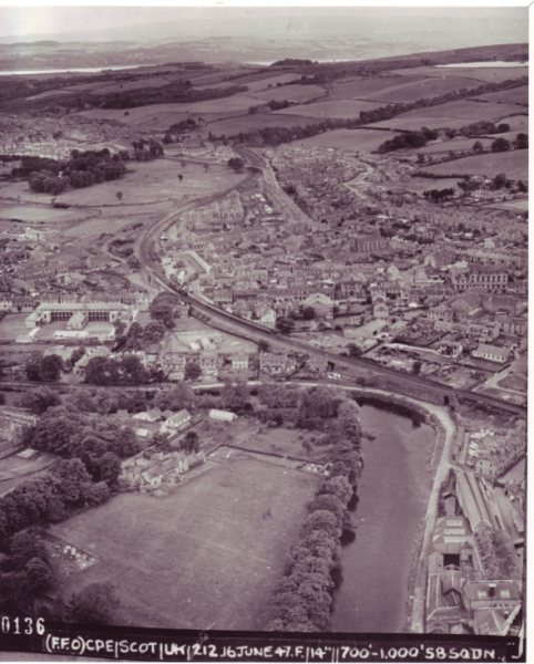
Photograph 7 – taken above Napierston Terrace and looking south-west
- At the bottom right corner of the photograph is a back view of the Front block of Napierston Terrace on the Jamestown / Bonhill road showing the round towers which housed the stairs
- Immediately above the Terrace and slightly to its left is the Tip Park. This had been a sand quarry which still shows signs of activity of some sort in the photo. The Ferry Fields housing estate, with Oakburn Walk etc, now stands on the site.
- The houses at Sandbank, still there, can just be seen above the Park and to their right is the Leven as it approaches the bend at Linnbrain Hole. The skimmer and entrance to Dalmonach lade is on the east bank of the river and the Craft is on the west.
- The field between the lade and Jamestown / Bonhill road is now a small housing estate called, appropriately enough, The Lade
- On the east side of the river bend is one of the best views we have of Dalmonach House which was the owners’ then manager’s house for Dalmonach Works. Just above the House are a number of smaller white buildings. This was a small-holding and piggery about the time the photo was taken. The lodge house for the entry to Dalmonach House is also clearly visible opposite the Sandbank houses. The lodge still stands and has been extended over the years.
- Immediately to the right of Dalmonach House and across the river is a fine view of the front of Linnbrain Terrace and also of India Street, both at the Craft gate in an area that used to be called Charleston. All of these buildings have gone.
- Just above Linnbrain Terrace and to its left at the bottom of Susannah Street standing on its own is Mathieson’s Mission gospel hall. It is no longer called Mathieson’s Mission, but it is still a Gospel Hall.
- The large gable just to the left above Mathieson’s Mission belongs to a building that was at that time the Co-op bakehouse, which was demolished not long after this photo was taken, and immediately above it is complete front view of the Co-op Halls in Bank Street
- To the left of Mathieson’s Mission the building and yard is the Scottish Co-operative Wholesale Society’s Funeral Dept’s garage and store in Steven Street. It stood where the Co-op Funeral Parlour now is and which for about 30 years in the early 20th century was the site of the Vale Empire Theatre.
- Across the railway line is a clear view of the back of St Mary’s school and above it and slightly to its left, the picture shows just how big Millburn Park is.
- In the distance to-wards the top left of the photograph is Cordale.
Photograph 8 – taken from only a few yards further on than 7, is probably another stereoscopic photo, looking south-west.
Much of the content is similar to what is in Photograph 7 but much of the detail is a lot clearer.
- Almost in the middle of the photograph there is a clear view of a short goods train standing on the Balloch line at Alexandria station. It is one of the older steam engines of a type no longer used by 1947 for pulling passenger trains and is almost certainly shunting wagons into the west goods yard at the station. It is a reminder that all the coal burned in Vale fireplaces in 1947 arrived in the Vale by train, and that many other goods were still delivered by train. There are two large goods yards in the photo on either side of the railway line. The west yard occupied the ground which is now the car park used by the shows when they visit Alexandria.
- At the bottom left of the photo is a view of Our Lady and St Marks Church among the trees close to the river and the tow-path and just above it again there is the back view of St Mary’s school.
- Almost opposite the centre of St Mary’s, on the other side of Bank Street, Tooraladdie Lane can be seen clearly. This is the first photo we have found which shows this lane and it would have to be aerial one anyway to show it in its entirety, since it is a dog-leg. It was a much-used short cut between Bank Street and Bridge Street. As can be seen it ran alongside the right-hand gable of a Bank Street building before doing a sharp left to pass between William Taylor’s joiners yard and Mathew Haggerty plumber’s shop and then enter Bridge Street almost opposite the building immediately to the left of the Baptist Church
- Angus the Bakers bakehouse and head office is immediately above the Baptist Church. Angus’s was in Leven Street, and just beyond Angus’s in Leven Street was the Vale of Leven Laundry building. Both are long gone, one is now a car park and the other a blaze football pitch.
- The Labour Exchange is just above the Laundry; it has been converted to flats.
- To the right hand side of the Labour Exchange is the entrance to the Emmet Park, home at that time to the Vale Emmet FC. To the left of the Emmet Park is Millburn Park home of Vale of Leven Juniors FC. The covered enclosure on the west side of the Park is not the present one. To the left of Millburn Park is Lesser Millburn which is now the ground of the Vale of Leven Cricket Club.
- Towards the top of the photo is Millburn Church with its spire, now collapsed, and beyond that the Hillfoot houses in Renton.
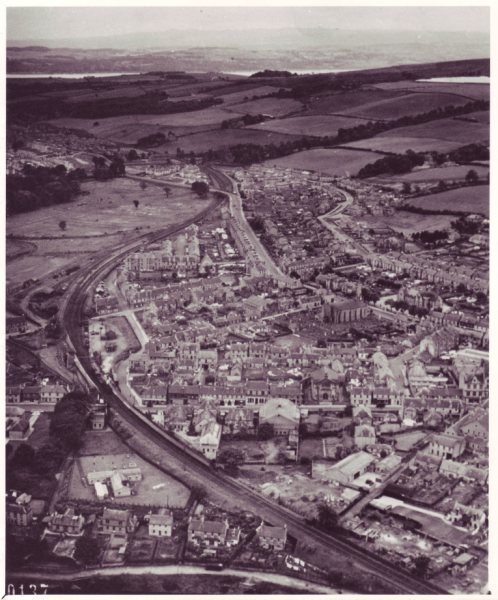
Photograph 9 taken from about the junction of Gilmour Street and Middleton Street in the middle of Alexandria looking north.
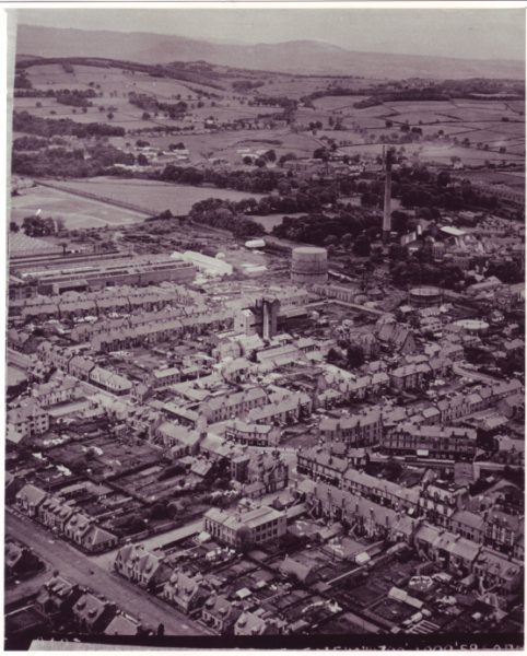
This photo is a vivid illustration of just how many houses and buildings there were in the centre of Alexandria in 1947, and it had been that way for most of the 20th century, although a few of the buildings had been demolished and replaced. There are even 2 1930’s 3 storey blocks of flats in the town centre, still standing, clearly visible. It is also the only photograph in which you can clearly see any part of the Fountain, even if it is just the top of it. Perhaps the photo’s greatest value is in showing points of interest in the side streets off of Main Street and Bank Street. These include:
- The large building with tall windows in the middle of the bottom part of the photograph is the Gilmour Institute on Gilmour Street. Looking due north from it, look at the size of the back gardens of both the houses on Middleton Street and the tenements on Bank Street, all the way to Hill Street where stands the first of the 1930’s blocks of flats.
- To the right of the Gilmour Institute is Main Street and diagonally above it is the junction of Bank and Main Streets with the Fountain just visible.
- On Main Street in the lower right of the picture there is a good view of the shops on the east side of the Street. All of these buildings from the British Linen Bank building north to the Fountain are still standing. South from there, all the buildings were knocked down and replaced.
- Directly above Main Street are the Bank Street buildings and shops. The most prominent is the Weir building, now gone, and to its right a view of Fordyce’s garage just set back from Bank Street. To the right of Fordyce’s garage is the Horseshoe Bar which in 1947 would still be under Mrs McLaren’s ownership. That building has survived and is now The Paint Pot.
- On the other side of Bank Street is a back view of Taylor’s Auction Rooms with its long corrugated iron roof. It too has survived and is now Bobby Biddulph’s carpet shop. To its left, the Fountain Place buildings have also survived.
- At the left hand end of the Weir’s Building is the Bank Street / Susannah Street junction. This top end of Susannah Street, which is all that is in the photograph, had 2 buildings of note but unfortunately in the photo Weir’s Building obscures them both. Next to Weirs Building and partly visible immediately above it was Susannah Street Schoolroom dating back to about 1816. It was demolished in the redevelopment. On the opposite side of the street from it was the Dyers Hall, later the Torpedo Club, later the Corner Pocket etc. Only part of its roof is visible in the photo.
- Going up Bank Street to the Fountain are the 3 shops which stood there until quite recently, when the last was demolished to make way for the non-existent new health centre. They are now a gap site.
- They stood on the corner of Craft or Alexander Street which nowadays, like Susannah Street, has been cut into two parts by McAlister Road. Just look how built up it was in comparison to to-day’s wide open spaces. It was also one of the Vale’s busiest side streets because it led down to the Craft gate. Two of the buildings in the photo still stand in what remains of Craft Street – one is the white single story temporary building which housed the predecessor of Social Security (it is now the dog training club) and the other almost opposite it whose back view appears in the photo, is the second 1930’s block of flats in the centre of Alexandria.
- The street running parallel to Craft Street and just above it in the photo is North Street. The main feature of North Street is the Gasworks which take up almost half of the north side of the street. Photograph 10 shows them in even greater detail.
- Just to the right of the Gasworks and on the opposite side of the Street is the former Roman Catholic Church in Alexandria (the first one in the Vale of Leven since the Reformation). A new Roman Catholic Church had been built on the site of the former Ferryfield Works about 1926 and since then the former church had been known as the Northern Halls. These were a Vale institution and were in great demand for dances etc.
- Just to the right of the Northern Halls is a 3rd gasometer, which is rarely seen, while diagonally across from it are a row of small cottages backing onto the 2nd gasometer already mentioned above. One of them is still standing. Right at the east end of North Street is the footbridge into the Craft, which is still in use.
- Moving left up to the top of North Street is a view of McKenzie’s pub while across the Main Street on the north corner of Hill Street is another good view of the Castle Danger tenement building.
- The background views over Jamestown and Balloch give an even better impression of just how extensive Levenbank Works were because they take up about two thirds of the width of the photo.
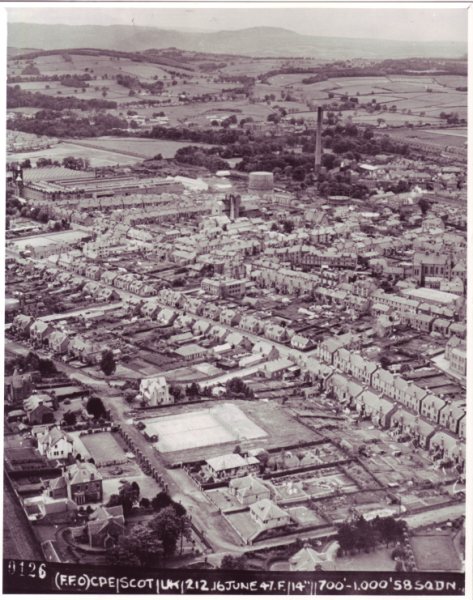
Photograph 10 – taken above the Gasworks, looking north-east
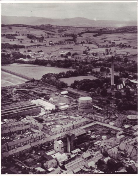
- The Gasworks are the centrepiece of this picture. Perhaps the most surprising thing about them is just how many houses there were crowded round them.
- Just above the Gasworks is a very clear view of the Craft stalk from ground to top. It was said to be the tallest chimney in Scotland and to be so tall so that the smoke which came out of it would not pollute the Vale. Both claims may well be true, but the greater height produced a greater draught, which meant more heat for less coal, so that may also have been the reason for its height.
- The background views at the top of the picture, particularly Drymen Road, Balloch are also clearer.
Photograph 11 – taken over Burnbrae looking north-east.
Most of the details in this picture have already been covered elsewhere in the commentary, although there are a couple of points in the background:
- At the top right hand corner what looks like a mound rising up behind the hills on the Gartocharn Road is exactly that – it is the Dumpling or Duncryne at Gartocharn.
- Below it on the right hand side and back in the Vale is a view of Tommy Anderson’s sawmill in what had been Milton Works just behind Milton Terrace, Jamestown.
- Above the Works / Sawmill the row of buildings is Milton Loan which ran between Davidson Stores and Levenbank Terrace (the Loan is still there). The largest of these buildings was the old Territorials’ Hall and beside it was the Railway Mission, a gospel hall which many local children attended in 1947. Both long gone.
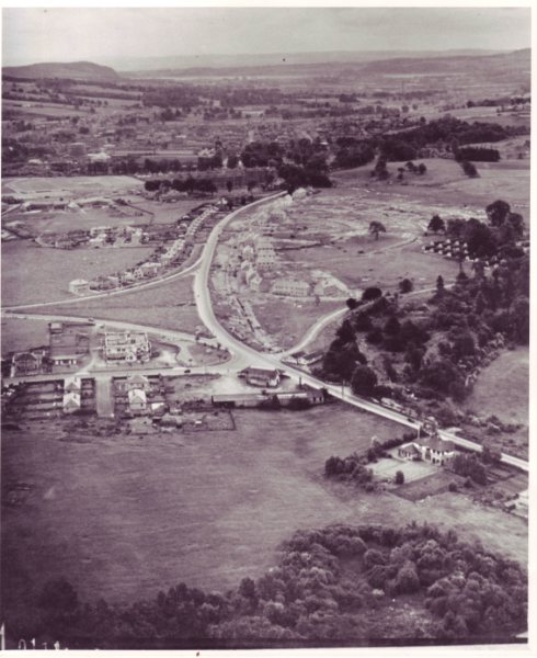
Photograph 12 – the next press of the button after 11, taken over Overton Road looking north

The most striking thing about this photograph is the complete absence of road traffic – no parked cars, no moving traffic not even a cyclist or a horse and cart. There are a number of other points of interest:
- Looking straight along Smollett Street, the slope on the Ritchie Hill is very noticeable and of course there are no buildings in the fields of the Hill – no Cowie or Ritchie Terraces and no Margaret Drive.
- There are no buildings on the south side of Hill Street between Smollett Street and Middleton Street which lets us see that although there is one wooden hut annexe in the Vale Academy at the south-east corner of the playground, there are no other huts anywhere around the school.
- There is a clear view of Bromley Hospital in the middle left of the photo and just below it is the south avenue up to Tullichewan Castle, although the Castle itself is not in the photo.
- To the right of Bromley are the tenements of Govan Drive and just behind it Argyll Street.
- Above Bromley on the left hand side of the photo are the foundations of the new Tullichewan housing estate and although there are no aluminiums yet in place, many of the brick-built terraces and semis along the front are well advanced.
- Above the new housing is Tullichewan Camp which is almost invisible in this photo but of which there is a clear view in Photograph 14.
- To the right of the camp is the British Silk Dyeing Company’s Silk Factory with its prominent chimney which used to perfectly bisect Ben Lomond as you travelled along Luss Road in front of Tullichewan. A large part of its site is now the Clairinsh / Inchcruin / Inchtavannach housing estate.
- Just below the Loch shoreline in Drumkinnon Bay and towards the top left of the photo, is a field in which the ground looks disturbed. This is the site of what was probably the busiest sand quarry in Scotland at the time, but the picture is too indistinct to make out any activity. (Paddy Caulfield was extracting sand for the building of the Loch Sloy Power Station. It was loaded onto barges at Drumkinnon and towed up to Inveruglas by tug, but there’s no sign of that in the photo.)
- Just below the quarry is another green field which was never developed until it was used for the entrance to Lomond shores, whose car parks Drumkinnon Quarry eventually became.
Photograph 13 –taken over Upper Smollett Street looking south, may have been taken at the same time as Photograph 12 with a back-facing camera.
Again many of the details in this image appear in other photos. However there are a few points of note:
- There is an almost complete view of the Burnbrae and Millburn housing estates
- Similarly, although it is further away and can’t be enlarged with much improvement, there is a complete view of Cordale estate as it was in 1947.
- Just above Cordale on the left of the photo there is clear evidence of the beginning of the building of Strathleven Industrial Estate.
- On the top left of the photo notice the size and shape of Dumbuck Hill, already a stone quarry but still pretty well intact in profile from the north.
Photograph 14 – taken above Drumkinnon Quarry looking due south
By the time this picture was taken the plane seemed to have turned and was flying south. It contains a number of noteworthy features including:
- The nearest building, standing all on its own at the lower right hand edge of the photo on what was at that time the A82 road, was the house of the Managing Director of the British Silk Dyeing Works – the Silk Factory – which is just out of this photo to the left. Since the factory was Swiss owned, the MD was Swiss. His name was Mr Hoffstedter, usually known as “Hoffie”. He was also the Swiss consul in Scotland and regularly flew the Swiss flag from the flagpole which is quite discernible on the left (or south) side of the house. So is the tennis court at the back of the house. The road is now Old Luss Road, the A82 having moved a few hundred yards up the hill, and the house, which was a manse after the Swiss moved on, is now a private residence.
- Just south of the house (above and to the left) at the junction of Balloch and Luss Roads is what was in 1947 McArthur’s Garage, although it did pass into the ownership of McLetchie & Clark about that time. The petrol pumps are hidden from views under the canopy at the front of the building and the sheds at the back are where repairs were carried out. The last owner was John Methven before it was demolished to make way for the entrance to Lomond Shores
- Just to the left of the Garage is a short road on which 4 houses stand. This is Drumkinnon Road and the scene is virtually unchanged to-day.
- The large white building across Balloch Road from the Garage i.e. above it in the photo, is the Loch Lomond Hotel then owned by the Mason family, later by Ma Barton. Now an apartment block but still very much recognisable as the building in the photo.
- Across Luss Road from the Hotel, i.e. to its right, is the entrance to Tullichewan Camp. It is likely that the white huts are the gatehouse / guardhouse. This is now the car park between The Princess Rose and MacDonald’s
- The triangular field above the Hotel formed by Luss Road on the right, Lomond Road at the top of the triangle and an unnamed road nearest, was formed when the new Lomond Road was built in the mid-1930’s. The point at which Lomond Road divided is just in the picture and no more, at the extreme left with the nearest road heading to Luss and the top one heading to Alexandria. The burn running through the field enters the Leven at the north edge of Fisherwood. The whole road system was replaced by the present roundabout when the Alexandria by-pass was built in the early 1970’s
- The rows of Nissen huts which made up the other ranks accommodation at the Camp were, at the time the photo was taken, completely empty. However 2 months later almost to the day, they were taken over by local families desperate for somewhere to stay, and they stayed in the huts until 1953 when the Camp was finally demolished. There are now houses on the site of most of the huts.
- The Lawrence Houses on Luss Road and Lomond Crescent were built in the 1930’s and still stand looking as if they were only a few years old. Note that the post war council houses in Lomond Road and Crescent had still to be built.
- Across Luss Road on its west side, there is a very clear view of the brick built houses in the new Tullichewan estate which look very near to completion. To the right of them the road system in the new estate, which was based on a number of crescents, is reasonably clear as is the preparatory work for the installation of the aluminium houses, which were already being built in the former Blackburn aircraft factory in Dumbarton
- About the top middle of the photograph, just below the tenement building in Argyll Street and to the right of Levenvale School, is Black’s Farm. The picture shows how extensive the farm buildings were, which is not surprising because it was the Home Farm in the heyday of Tullichewan Castle Estate. Although the farm buildings survived for many years, the farm lost all of its land to Tullichewan housing estate, the Vale Hospital and the new post-war houses in Levenvale.
- Just to the left of the farm is Argyll Park of which there is an uninterrupted view because as yet there were no houses on the south side of Argyll Street down to the Garden City nor on the north side before Hardie Street.
- On the other side of the Park the temporary Maycrete houses can be seen.
- In the middle of the picture, close to the top, stands Bonhill Parish church with all of the fields behind it still free of housing. Similarly the Ladyton and Nobleston ground on the hills at the left is still farm-land
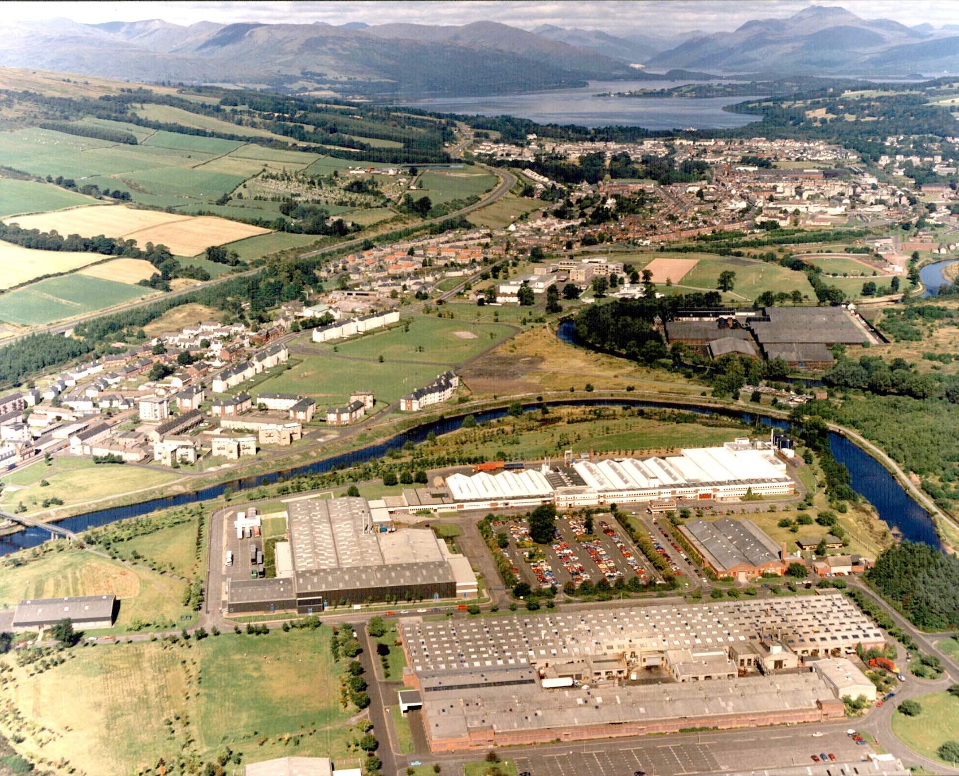
For comparison purposes this is an image that was taken for the Polaroid Corporation in the 1980's when they were major employers in the area. The picture focusses on the Polaroid plant (in the foreground) but most of the rest of the Vale is also visible. Click image for larger version.
![]()