Vale Memories
by
Malcolm Lobban
Rough notes on life in the Vale of Leven circa 1938 to 1956 (un-published)
and recorded in June 1994 for The Local History Section of Dumbarton Library.
Introduction October 2011.
It’s now 17 years since I wrote the Memories of the Vale – which I expanded into a book in 2006 “A Close Community, Life in an Alexandria Tenement”, which is still available in Alexandria Library. I am delighted to make these notes available for publication, just as they were written, on the Vale web-site, which is required reading for Vale expats in sunny Australia. However a lot of information has come to light in those 17 years and there are a number of things in the article which I can now update as follows:
1. The proper spelling for the Liddite was in fact Lyddite.
2. The Tin Kirk was indeed a Church of Scotland Church called St Andrews which was part of Alexandria Parish Church
3. The “Huts” were built by the Admiralty during World War 1, with occupation of the 150 houses starting about 1915, not after it, as the article says.
4. Hardie, Lansbury and Burns Streets were not named after Vale councillors, although with two of them I was on the right track. Hardie St (which I referred to as Hardy) was named after Keir Hardie regarded as the founder of the Labour Party, Lansbury was called after George Lansbury the national leader of the Labour Party about the time that Levenvale was built. Burns Street was named after Robert Burns.
5. The Craft stalk was demolished in 1964.
6. Broomley House which became the Henry Brock Hospital was never owned by the Brock family. His widow used a bequest which he left on his death to buy Broomley for conversion to a hospital. Henry Brock had been a director of the UTR, Commanding Officer of the Dumbartonshire Rifle Volunteers, and unsuccessful Conservative Parliamentary for Dumbartonshire, but he lived at Darleith House for the later years of his married life and his parent’s home was Auchenheglish.House, later the Lomond Castle Hotel.
The Brock Baths in Dumbarton were built in memory of Walter Brock, perhaps the outstanding shipbuilding engineer of his generation, who was a nephew of the Denny shipbuilding family. He started his shipbuilding career at another yard on the Clyde before joining Dennys where he eventually became a very successful chairman, in the 1890’s and early 1900’s. Amongst his many other achievements, Brock was a personal founder investor in what became the Irrawaddy Flotilla based in Rangoon, in what was called Burma at the time, backing up with his personal money his business judgement which saw Dennys and another Clydeside shipbuilder, Hendersons found this highly successful joint venture at almost the other end of the Empire. If Walter and Henry Brock were members of the same family, they were not close relations.
Vale Memories
June 1994 Text
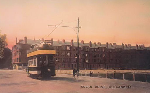
Argyll Street and Govan Drive appear to have been built on part of the Tullichewan Estate farmland. The tenements were accommodation for employees of the Argyll Motor Works later called Gunwork during WW I and Torpedo Factory WWII.
The piece of land where now the public baths stands was known as the Lyddite being an early extension of the Gunwork (Munitions Factory) and something to do with high explosives for shells. The area was wasteland until sometime possibly mid-l940s when several concrete-built, one-storey houses were constructed on the site, prior to the baths being built.
The Argyll Park was still under construction during the early war years WWII. It, too, had been a part of the Tullichewan Farm land. I recall seeing an old bathtub used as a cattle drinking trough still in situ while the Argyll Park was being built.
During the early 1940s the shops at Hillview (on the main Balloch Road) were as follows - (Left to Right as you face the building):
Old Mrs Campbell's Newsagents and general shop. Sometimes she was known as "Auld Ane-a-Hauf". This arose from her method of counting out your change. Instead of saying, for instance, “three ha'pence”, she said "one a half i.e. one and a half pence change. Sounds complicated, but that's how it was. In short, a half pence to her was just a half (this was of course during the old L.S.D. currency).
Next to Campbell's was a general store run by a man called Bud Fisher who was something of a character, but early in the war years the shop was taken over by a mother and daughter named McLaren who sold general groceries. They were friendly folk and always very fair with the customers, especially during the food rationing period - and more especially at the start of each sweetie rationing period (sweets were dealt with slightly differently during the food rationing.)
Next to Mrs Mclaren's was a drapers and Hillview Post Office run by a Mrs. Malcolm. She, too, was a nice person and well-liked by the locals.
Next to Malcolm's, at the corner of Hillview and Govan Drive, were premises which were boarded-up and kind of derelict. Older folk told me it used to be an ale-house of sorts and supplied what was described as "munition ale". I never discovered what this meant. But old-timers said it was a lousy beer, in any case!
At some point during the war, the property was refurbished and taken over by Andy Clugson, who used it as a kind of cafe-cum-shop which he named “The Bonne Bouche" (not sure of the spelling). Andy was a down-to earth person, maybe just a wee bit rough-and-ready. He sold various items including toilet items (including condoms before they became "respectable” and which men used to obtain with a nod and a wink. Others referred to them as "Three-in-a-box" or "Gies a holiday outfit, Andy!). Andy also kept a racing greyhound (s) and customers to the cafe often ''enjoyed'' the aroma of cod's heads and other ''delicacies'' being cooked in the back shop.
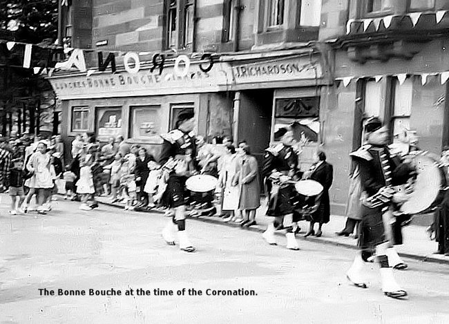
Around the corner from Hillview (Govan Drive) was a baker's shop run by Kate Richardson, another well-liked trader.
Auld Campbell's shop was taken over during the war years by Jessie Sweeny, who made some slight changes, but she still sold newspapers and sundry items.
Along from Hillview and part-way into Argyll Street was a piece of land owned by the Church (Church of Scotland? not sure). A little church stood there, known locally as "The Tin Kirk", since it was constructed almost entirely with corrugated sheeting. The grounds were badly overgrown and neglected and the whole area was surrounded by a six-feet high metal fence with pointed tops - which didn't deter the Argyll Street lads from scaling it to retrieve lost balls etc.!
The Argyll Street tenement stood four storeys high and had eight closes, numbered 6,8,10,12,14,16,18 and 20. Each close had eight, two-roomed flats and four single-ends. Each level shared a communal cludgie (toilet). As far as I can recall the building had more than one factor (rent man) suggesting several owners. All the flats were rented and occupied by tenants during the war years. There was no hot water system installed, and some households had installed gas geysers at their own expense. Similarly there were no bathrooms. Each close was serviced by a common washhoose in the back court. Families look turns to use this and the common drying green (no grass). Each back court was fenced off with iron railings (spiked) approx 5 ft high. I think these may have been removed during the Wartime scrap drive. The midden bins were located in a recess at the ends of each washhoose and a lane ran between Argyll Street and Govan Drive to allow access to midden motors etc.
Govan Drive had basically the same conditions. But some of the flats were larger and had inside toilets. Govan Drive may have been planned for supervisory employees, etc. Hillview (mentioned above) was more or less an extension of the Govan Drive building.
Facing Argyll Street tenement was a small grazing park and Tullichewan Farm.
The farmer's name was Black (known locally as "Paw Black" - maybe his first name was Paul, not sure?) During the war the farm supplied fresh milk to the locals, who went there with jugs, cans and other containers. The milk was always warm.
The small grazing park was fenced off from the street by the same type of metal fence that I mentioned at the Tin Kirk. The park was invariably used for animals which were about to give birth. (See my "A Close Community", The Scottish Banner, March 1994; copy on file).
Beyond the farm is Levenvale Primary School which extends to Hardy Street (again, the school seems to have been built on Tullichewan farmland). At the corner of Hardy Street and Argyll Street was a Co-operative Society shop (known locally as ''Levenvale Store").
When I arrived in the Vale (1938), some of the Levenvale Council houses were still under construction. I’m not sure about the timber houses and the area then called “Timber Town”. But older people still called the whole area of Levenvale “The Huts” (this refers to wooden houses built after WW1). One of the original “huts” still stood in Burns Street, facing the railway. It was used as a community centre and I recall dances being held there in the l940s. The three streets running off Argyll Street are Hardy Street, Lansbury Street and Burns Street (I think named after local Vale Councillors).
Argyll Street ends at the railway. Although there is now a footbridge to Rosshead (the Bowl o Meal or Boll o Meal of old), there was none in my time, but people took a shortcut through a gap in the railings to reach the River Leven.
Returning back up Argyll Street, we have an entrance to the Park and a row of privately-built houses which was known as “The Garden City” (which backs onto the Park). Further on was a small grazing field (where now Council houses stand) between the Garden City and the end of the Argyll Street tenement. This was owned by the farm and a friendly wee pony named ''Sheila'' browsed here. She was a great favourite with the local children who used to bring bread and stuff to feed her. Farmer Black used her as a carthorse for collecting brock (pig swill) around the doors.
This land was later used for air raid shelters for the Argyll Street tenantry - each close having its own shelter, which the occupants made as comfortable as possible with odd bits of furnishings. I seem lo recall, because of being partly underground, they were prone to severe flooding. The top of each was covered with earth the total effect being a series of humplets which we kids used to good effect during the stane and divot fights with rivals from Govan Drive!
A lot of people don't realise that a burn runs from Tullichewan (underneath the street, under the railway) down Argyll Street and emerges at the Leven at the bottom of Heather Avenue, at what used to be called “The Pan Lade (a favourite swimming area at one time!). I recall a spring lamb being rescued via a manhole in the centre of Argyll Street. It had strayed into the burn from Tullichewan Park (before the housing scheme was built) and got washed through the conduit. I think someone heard its cries in the street.
The house which used to be the south lodge entrance to Tullichewan Estate is still standing, now having been modernised as a private dwelling.
Getting back to air-raid shelters, it was during the Clydebank Blitz that the cellar of Levenvale School was used. I recall community singing while the bombing was going on.
Each close had also been reinforced with steel props and girders, and a brick wall (Baffle Wa) was built in front of and across each closemouth - presumably to prevent shrapnel from entering the close. The edges of these walls were painted white (as were many other possible obstructions) to assist during the Black-out regulations.
Heather Avenue (no heather?) was nothing more than an unsurfaced cart track during the war years. It was lined on each side by fairly old trees - most of which were felled to allow better visibility to gun emplacements located in the Torpedo Factory (I think these were anti-aircraft guns "Ack-Ack" as they were styled).
At a point a few yards beyond where the Heather Avenue crosses over the railway (and just past the entrance to Christie's House (Christie of Croftengea) a tall tree (elm?) was pointed out as ''Fletcher's Tree". The story goes that a man of that name was hanged on the tree (circumstances not known), and we children used to pass the tree quietly en route to the Leven with eyes gazing upwards to the branches of the tree. I recall the tree had one of those peculiar entanglement of branches which formed a distinct dark mass. Many a ''fertile'' childish imagination saw this as a body!
During the war the area where Rosshead housing estate now stands was a grazing field (I think it belonged to the Groftengea Works "The Craft”). It was also known as the Bowl o Meal or Boll o Meal. During the 1940s two bi-planes force landed in the field, one of which had damaged undercarriage.
Speaking about ''The Craft", next to Tennants Brewery, the Craft Stack (chimney) was the tallest in Scotland. It was pulled down I think, during the 1950s or early l960s?
The Rosshead, as we knew it was the small enclosed meadow through which the lade flowed into the Croftengea Works. We used to swim barescudd|y in one area of the lade - although strictly out of bounds and private! Parts of the high, sandstone wall can still be seen, but the pleasant meadow is no more, being overgrown with trees - and the once-pure lade water now stagnant and polluted by household rubbish. A complete eyesore!
A branch railway of the Forth & Clyde Railway left the main line behind Fisher’s Wood (opposite Burn Street, Levenvale) and crossed the Leven by way of the Stirling Bridge, (known locally as "The Stuckie Brig"), to the station at Jamestown. (A smaller branch also went into Croftengea Works). This line originally led to Stirling and a Push-and-Pull type of train carried passengers at one time (not in my time, though). During my day the line only went as far as Croftamie station - which used to be listed as Drymen station. The curious thing here was that the station was in Dunbartonshire, while Drymen was in Stirlingshire - or was it the other way around?
While employed by British Railways (circa 1953-56) at Balloch, first as a loco fireman then platelayer, I ''fired'' occasional goods trains to Croftamie. I also worked on the track at Balloch including the extensive sidings no longer there) and on the main line as far as a point near India Street. The condition of the track now would bring tears to many an old ganger's eyes!
Another favourite haunt for the Argyll Street and Govan Drive weans was in the Broomley Park, before the Vale Hospital was built. Also in the fir plantation which stretches from Broomley Lodge (opposite the Torpedo Factory gate) to the south Lodge of Tullichewan (just past the entrance to Argyll Street).Parts of this plantation are still evident, but in the 1940s the trees were younger and formed dense cover for wildlife (especially the human kind!) The grazing ground behind the "Plannie" (plantation?) was used by Black the farmer, who, being a Special Constable at the time, took great delight in capturing us kids and marching us to Hill Street Polis Office, where we received a severe warning. The "offence" being Tramping Down Grazing Ground!
Before the Vale of Leven Hospital was built, the original Broomley House was used as the Henry Brock Hospital (named after the family who owned the land - also connected with the Brock Baths in Dumbarton).
Tullichewan Castle was still standing, and was used part of the time by the Americans who came over during the war to lay an oil pipeline from, I think, Finnart, Loch Long, to Grangemouth. Much of the equipment was stored along the "Bay Road" (Pier Road) at Balloch, and accommodation nissan huts were erected at the north end of Tullichewan (near the present caravan park). The Admiralty also had a site in this area. The Yankee Camp was later taken over by homeless natives (called “squatters”). Many respectable families lived here until sufficient Council accommodation was built i.e. Tullichewan (prefabs first) and Haldane ("Mull o Hadden” as it was called then). There were also "squatters'' living in Millburn area near the football park (when we had the Vale Juniors).
At this point I don't want to stray too far away from my own “hunting ground” Argyll Street, Levenvale and Balloch. In my day there were few cars on the road and kids had plenty of scope for safe street games - bat rounders being a great favourite. Lassies played peever (hop-scotch) and imaginary “wee shops” where the currency was “wally money” (bits of broken crockery, the most treasured being bits showing gold gilt). They also excelled in rope skipping games.
Boys played “jiggies” (marbles). One game called “dabby” was where all participants placed a number of Jiggies inside a circle drawn in the dirt. Each took turns to toss a larger jiggy (a dabby) into the circle and keep all that were knocked outside. Boys also ran with “girds” (hoops). These ranged from motorcar tyres to bicycle rims, and were propelled either with a stick or by means of a “cleek” piece of wire shaped into a hook at one end and a handle at the other.
There were other games which involved the use of cigarette cards (commonly included with many brands of cigarettes – and often very educational).
Boys and girls who were approaching puberty, had more exciting games in mind. “Truth and Dare” was a game for Blackout evenings of the l940s.
There was a time when I could name every person who lived in Argyll Street. Now I can hardly recall any. But those I do remember include our neighbor next door at No 10 top flat, Jimmy Docherty, who drove the Luss Bus (SMT) and his brood (his wife died during the war); The Munros in the bottom flat; The Prices; No6 The MacKinnons; No8 the MacLeans; No.12 the Melvins; No.l6 old Mrs Sweeny and her poor daughter Martha, Tillie Howatt and her brood; and at No.20 the MacGregors....Oh aye..at No.14 wee Frank and Dora Mulholland and their two sons, John, who went to England and once played f or Plymouth Argyle football club, and his brother Frank (married Marg. Mathews) now at 11 Miller Road, Haldane.
I’ll probably think of much more as time goes on.
M. Lobban 9/6/94.
Balloch
![]()